

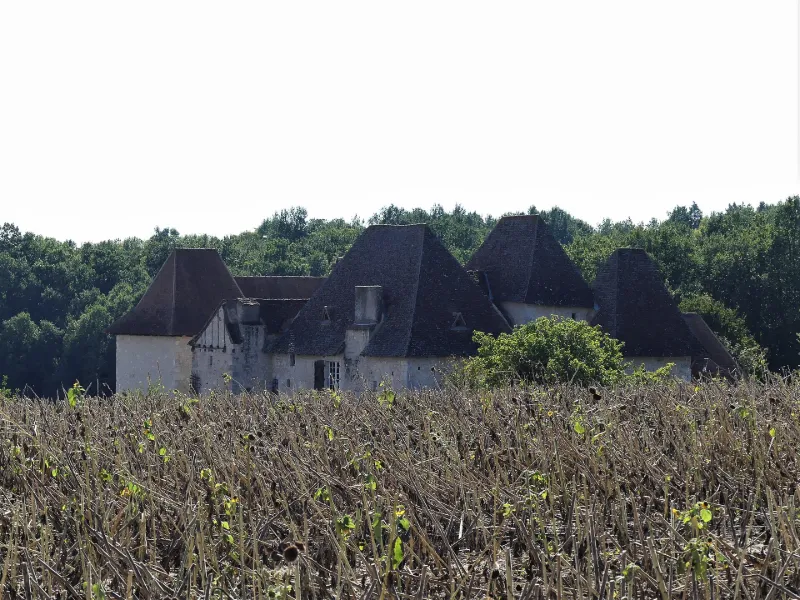
L'Aubespin Manor
No reviews yet
Have you flown here? Share your experience with other pilots.
+ Write the first reviewHistory
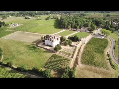
15e siècle ; 16e siècle ; 17e siècle Le manoir semble devoir à la période des guerres de Religion un système défensif élaboré. Son implantation pourrait remonter au 15e siècle avec des aménagements au 17e. Seul subsiste le logis principal. Le cadastre de 1823 montre la présence, outre du logis principal, de deux autres corps de bâtiments : dans l'angle nord-ouest un bâtiment en équerre, aujourd'hui détruit, dont l'extrémité arrondie indique la présence d'un four ; au sud-est, une grange. L'ensemble de ces bâtiments était relié par un mur d'enceinte. Le logis présente un plan en L, cantonné de deux tours aux angles sud-est et nord-ouest. Ces deux tours flanquent les murs du logis et assurent le dispositif défensif complété par celui de la grange.
Map and restricted areas
Open in the main mapRestricted zones
| Zone | Category | Limits | Conditions |
|---|---|---|---|
| Ctr Bergerac |
Zone de contrôle civile | 50 m above ground level → 610 m above sea level | Flights above 50 metres are forbidden without the prior agreement of air traffic control |
| Zena Perigord Low | ZRT | FL 165 / FL 195 | SUP AIP 062/26 · Du jeudi 23 avril 2026 au jeudi 25 mars 2027 |
| Zena Perigord Medium | ZRT | FL 195 / FL 245 | SUP AIP 062/26 · Du jeudi 23 avril 2026 au jeudi 25 mars 2027 |
| Zena Perigord High | ZRT | FL 395 / UNL | SUP AIP 062/26 · Du jeudi 23 avril 2026 au jeudi 25 mars 2027 |
Nearby aerodromes
Open aerodromes within 25 km of the spot, heliports included, with their distance and direction from the spot. Near an aerodrome, drone flying is prohibited or height-limited: check the UAS zones map.
| Aerodrome | Type | Distance | Elevation |
|---|---|---|---|
| Bergerac-Roumanière Airport | Airport | 11 km N | 52 m |
| Pressignac Vicq Rebeyrotte | Aerodrome | 24 km NE | 196 m |
Aviation weather (METAR and TAF)
LFBE – Bergerac-Roumanière Airport VFR
METAR
METAR LFBE 171330Z AUTO 20006KT 160V230 9999 FEW035 OVC100 17/14 Q1002 TEMPO 24015G25KT 4000 SHRA BKN020TCU
- Wind
- 200°, 11 km/h
- Visibility
- 10 km or more
- Clouds
- Few (1-2/8) at 3,500 ft (1070 m) ; Overcast (8/8) at 10,000 ft (3050 m)
- Temperature
- 17 °C, dew point 14 °C
- QNH
- 1002 hPa
- Flight category
- VFR: ceiling > 3,000 ft and visibility > 5 mi
TAF
TAF LFBE 171100Z 1712/1812 24010KT 9999 BKN020 TEMPO 1712/1714 24015G25KT 3000 RA OVC010 PROB30 TEMPO 1714/1720 24015G25KT 4000 SHRA BKN020TCU TEMPO 1720/1812 24015G25KT 3500 SHRA BKN010 BKN040TCU PROB30 TEMPO 1722/1802 24020G35KT 2000 TSRA BKN008 BKN020CB
| Period (local time) | Change | Wind | Visibility | Weather | Clouds |
|---|---|---|---|---|---|
| 17/11 13:00 → 18/11 13:00 | Initial conditions | 240°, 19 km/h | 10 km or more | Broken (5-7/8) at 2,000 ft (610 m) | |
| 17/11 13:00 → 17/11 15:00 | Temporarily | 240°, 28 km/h, gusts 46 km/h | 3.0 km | Rain | Overcast (8/8) at 1,000 ft (300 m) |
| 17/11 15:00 → 17/11 21:00 | Temporarily, probability 30% | 240°, 28 km/h, gusts 46 km/h | 4.0 km | Showers of rain | Broken (5-7/8) at 2,000 ft (610 m) (towering cumulus) |
| 17/11 21:00 → 18/11 13:00 | Temporarily | 240°, 28 km/h, gusts 46 km/h | 3.5 km | Showers of rain | Broken (5-7/8) at 1,000 ft (300 m) ; Broken (5-7/8) at 4,000 ft (1220 m) (towering cumulus) |
| 17/11 23:00 → 18/11 03:00 | Temporarily, probability 30% | 240°, 37 km/h, gusts 65 km/h | 2.0 km | Thunderstorm rain | Broken (5-7/8) at 800 ft (240 m) ; Broken (5-7/8) at 2,000 ft (610 m) (cumulonimbus) |
Weather and Kp index
| Day | Weather | Temp. min. / max. | Wind | Rain | Max Kp |
|---|---|---|---|---|---|
| Tue 17 Nov | Heavy rain | 13° / 15° | 22 km/h SW | 8.3 mm | 5 |
| Wed 18 Nov | Partly cloudy | 12° / 16° | 26 km/h W | 9.5 mm | 5 |
| Thu 19 Nov | Rain | 10° / 13° | 32 km/h W | 16 mm | 3 |
| Fri 20 Nov | Rain | 10° / 14° | 24 km/h SW | 14 mm | 3 |
| Sat 21 Nov | Cloudy | 8° / 14° | 14 km/h E | 3.6 mm | – |
| Sun 22 Nov | Showers | 11° / 14° | 26 km/h W | 3.5 mm | – |
| Mon 23 Nov | Cloudy | 8° / 14° | 13 km/h SW | – | – |
Hour by hour: Tuesday 17 November
| Time | Weather | Temp. | Wind | Rain | Clouds | Kp |
|---|---|---|---|---|---|---|
| 15:00 | Heavy rain | 15° | 20 km/h SW | 2.2 mm | 100 % | 4 |
| 16:00 | Heavy rain | 14° | 18 km/h SW | 4.1 mm | 100 % | 4 |
| 17:00 | Heavy rain | 13° | 13 km/h SW | 1.5 mm | 100 % | 4 |
| 18:00 | Cloudy | 13° | 17 km/h SW | – | 99 % | 4 |
| 19:00 | Cloudy | 13° | 17 km/h S | – | 98 % | 5 |
| 20:00 | Cloudy | 14° | 20 km/h SW | – | 100 % | 5 |
| 21:00 | Light rain | 14° | 21 km/h SW | 0.1 mm | 100 % | 5 |
| 22:00 | Light rain | 14° | 22 km/h SW | 0.4 mm | 100 % | 5 |
Hour by hour: Wednesday 18 November
| Time | Weather | Temp. | Wind | Rain | Clouds | Kp |
|---|---|---|---|---|---|---|
| 06:00 | Fair | 13° | 20 km/h W | – | 26 % | 4 |
| 07:00 | Clear sky | 13° | 21 km/h W | – | 12 % | 4 |
| 08:00 | Fair | 12° | 20 km/h W | – | 19 % | 4 |
| 09:00 | Fair | 12° | 18 km/h SW | – | 14 % | 4 |
| 10:00 | Fair | 14° | 21 km/h W | – | 33 % | 4 |
| 11:00 | Showers | 15° | 21 km/h SW | 1.4 mm | 70 % | 4 |
| 12:00 | Partly cloudy | 14° | 26 km/h W | – | 78 % | 4 |
| 13:00 | Partly cloudy | 15° | 25 km/h W | – | 59 % | 3 |
| 14:00 | Fair | 16° | 20 km/h SW | – | 17 % | 3 |
| 15:00 | Partly cloudy | 16° | 20 km/h W | – | 62 % | 3 |
| 16:00 | Partly cloudy | 16° | 19 km/h W | – | 54 % | 3 |
| 17:00 | Fair | 15° | 14 km/h SW | – | 13 % | 3 |
| 18:00 | Fair | 13° | 10 km/h SW | – | 20 % | 3 |
| 19:00 | Cloudy | 12° | 9 km/h S | – | 100 % | 2 |
| 20:00 | Light rain | 13° | 14 km/h SE | 0.1 mm | 100 % | 2 |
| 21:00 | Light rain | 13° | 20 km/h SE | 0.2 mm | 100 % | 2 |
| 22:00 | Heavy rain | 13° | 21 km/h SE | 2.7 mm | 100 % | 2 |
Sunrise and sunset
| Day | Dawn | Sunrise | Golden hour | Sunset | Dusk | Day length |
|---|---|---|---|---|---|---|
| Tue 17 Nov | 07:26 | 07:57 | 07:57–08:42 · 16:43–17:28 | 17:28 | 18:00 | 9 h 30 |
| Wed 18 Nov | 07:27 | 07:59 | 07:59–08:44 · 16:42–17:27 | 17:27 | 17:59 | 9 h 28 |
| Thu 19 Nov | 07:28 | 08:00 | 08:00–08:45 · 16:41–17:26 | 17:26 | 17:58 | 9 h 26 |
| Fri 20 Nov | 07:29 | 08:01 | 08:01–08:47 · 16:40–17:25 | 17:25 | 17:57 | 9 h 24 |
| Sat 21 Nov | 07:31 | 08:03 | 08:03–08:48 · 16:39–17:25 | 17:25 | 17:57 | 9 h 22 |
| Sun 22 Nov | 07:32 | 08:04 | 08:04–08:49 · 16:38–17:24 | 17:24 | 17:56 | 9 h 20 |
| Mon 23 Nov | 07:33 | 08:05 | 08:05–08:51 · 16:37–17:23 | 17:23 | 17:55 | 9 h 18 |

Reviews (0)
Log in to review this spot. Log in · Create a free account
No reviews yet. Share yours!