

La Mure Windmills
No reviews yet
Have you flown here? Share your experience with other pilots.
+ Write the first reviewHistory
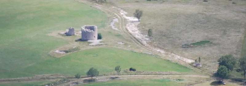
17e siècle (?) Huit moulins à vent ont été érigés sur le territoire de la commune de Vassieux, l'époque de construction du plus ancien remontant à la période médiévale. Il ne reste, à ce jour, que deux moulins, bâtis au sommet de la colline de La Mure, au nord du village. Le moulin situé à l'Est est le plus petit. Il s'agit d'une tour ronde typique des moulins à vent de type provençal ou languedocien. L''intérieur abritait probablement un grenier au rez-de-chaussée ainsi qu'une chambre de meunerie à l'étage. Des ailes mises au vent par une crémaillère intérieure assuraient le fonctionnement du mécanisme. Le deuxième moulin se compose d'une imposante tour cylindrique. Une porte située face à l'est s'ouvre sur un couloir. En juillet 1944, celui-ci fut utilisé par les SS comme point fortifié. Le bâtiment est édifié sur deux niveaux, le rez-de-chaussée étant occupé par le grenier et le deuxième niveaux servant de chambre de meunerie. La chambre renfermait deux meules actionnées par un mécanisme aménagé sous une coiffe. Une crémaillère intérieure permettait la rotation du toit ainsi que des ailes. Les éléments en bois du moulin, notamment ceux composant le mécanisme, ont aujourd'hui disparu. La période de construction des deux moulins peut se situer au 17ème siècle ou à la fin du 16ème siècle.££L'existence de ces huit moulins à vent, indispensables sur ce plateau relativement aride, représente un cas unique en Rhône-Alpes et fort rare en France. Il s'agissait de moulins familiaux. Les moulins de La Mure furent par la suite utilisés comme bergeries, remises à outils puis comme fours à chaux.
Map and restricted areas
Open in the main mapRestricted zones
| Zone | Category | Limits | Conditions |
|---|---|---|---|
| Zrt Rone 3 Bravo | ZRT | From the ground up to about 2,000 m above sea level | SUP AIP 207/26 · Du lundi 28 septembre au vendredi 16 octobre 2026 |
| GAP | Zone réglementée | 1006 m above ground level → 4126 m above sea level | Vols interdits sauf lorsque the official document of the zone l'autorise explicitement ou avec l'accord du gestionnaire de la zone lorsqu'il est désigné par the official document of the zone |
Nearby aerodromes
Open aerodromes within 25 km of the spot, heliports included, with their distance and direction from the spot. Near an aerodrome, drone flying is prohibited or height-limited: check the UAS zones map.
| Aerodrome | Type | Distance | Elevation |
|---|---|---|---|
| Saint-Jean-en-Royans Airport | Aerodrome | 14 km NW | 264 m |
| Altisurface de l'Escoulin | Aerodrome | 15 km SW | 660 m |
| Col de Bacchus Airstrip | Aerodrome | 18 km W | 975 m |
Aviation weather (METAR and TAF)
LFLU – Valence-Chabeuil Airport VFR
METAR
METAR LFLU 171330Z AUTO 20010KT 9999 FEW056 BKN150 OVC190 13/11 Q1003
- Wind
- 200°, 19 km/h
- Visibility
- 10 km or more
- Clouds
- Few (1-2/8) at 5,600 ft (1710 m) ; Broken (5-7/8) at 15,000 ft (4570 m) ; Overcast (8/8) at 19,000 ft (5790 m)
- Temperature
- 13 °C, dew point 11 °C
- QNH
- 1003 hPa
- Flight category
- VFR: ceiling > 3,000 ft and visibility > 5 mi
TAF
Weather and Kp index
| Day | Weather | Temp. min. / max. | Wind | Rain | Max Kp |
|---|---|---|---|---|---|
| Tue 17 Nov | Cloudy | 7° / 10° | 12 km/h S | 4.1 mm | 5 |
| Wed 18 Nov | Partly cloudy | 5° / 10° | 17 km/h W | 3.6 mm | 5 |
| Thu 19 Nov | Showers | 3° / 8° | 19 km/h S | 15 mm | 3 |
| Fri 20 Nov | Light rain | 3° / 6° | 10 km/h S | 4.3 mm | 3 |
| Sat 21 Nov | Clear sky | 3° / 9° | 8 km/h NE | 0.9 mm | – |
| Sun 22 Nov | Fair | 4° / 9° | 15 km/h NW | 15 mm | – |
| Mon 23 Nov | Cloudy | 0° / 6° | 10 km/h N | 2.4 mm | – |
Hour by hour: Tuesday 17 November
| Time | Weather | Temp. | Wind | Rain | Clouds | Kp |
|---|---|---|---|---|---|---|
| 15:00 | Cloudy | 10° | 9 km/h S | – | 100 % | 4 |
| 16:00 | Cloudy | 9° | 10 km/h S | – | 100 % | 4 |
| 17:00 | Rain | 9° | 7 km/h S | 0.7 mm | 100 % | 4 |
| 18:00 | Heavy rain | 8° | 9 km/h S | 1.3 mm | 100 % | 4 |
| 19:00 | Rain | 8° | 11 km/h S | 0.5 mm | 100 % | 5 |
| 20:00 | Light rain | 8° | 10 km/h S | 0.3 mm | 100 % | 5 |
| 21:00 | Light rain | 8° | 10 km/h S | 0.2 mm | 100 % | 5 |
| 22:00 | Fog | 8° | 12 km/h S | – | 90 % | 5 |
Hour by hour: Wednesday 18 November
| Time | Weather | Temp. | Wind | Rain | Clouds | Kp |
|---|---|---|---|---|---|---|
| 06:00 | Cloudy | 7° | 9 km/h SW | – | 99 % | 4 |
| 07:00 | Partly cloudy | 8° | 14 km/h SW | – | 84 % | 4 |
| 08:00 | Fog | 8° | 15 km/h SW | – | 87 % | 4 |
| 09:00 | Fog | 8° | 16 km/h W | – | 68 % | 4 |
| 10:00 | Fog | 8° | 15 km/h W | – | 48 % | 4 |
| 11:00 | Partly cloudy | 9° | 16 km/h W | – | 42 % | 4 |
| 12:00 | Showers | 10° | 16 km/h W | 0.2 mm | 42 % | 4 |
| 13:00 | Partly cloudy | 10° | 17 km/h W | – | 58 % | 3 |
| 14:00 | Showers | 10° | 17 km/h W | 0.4 mm | 52 % | 3 |
| 15:00 | Showers | 10° | 15 km/h W | 0.1 mm | 57 % | 3 |
| 16:00 | Partly cloudy | 9° | 14 km/h W | – | 80 % | 3 |
| 17:00 | Showers | 8° | 9 km/h SW | 0.4 mm | 67 % | 3 |
| 18:00 | Showers | 6° | 9 km/h S | 0.4 mm | 73 % | 3 |
| 19:00 | Partly cloudy | 6° | 7 km/h S | – | 68 % | 2 |
| 20:00 | Fog | 6° | 8 km/h SE | – | 90 % | 2 |
| 21:00 | Partly cloudy | 5° | 8 km/h S | – | 90 % | 2 |
| 22:00 | Cloudy | 5° | 10 km/h SE | – | 99 % | 2 |
Sunrise and sunset
| Day | Dawn | Sunrise | Golden hour | Sunset | Dusk | Day length |
|---|---|---|---|---|---|---|
| Tue 17 Nov | 07:07 | 07:39 | 07:39–08:24 · 16:23–17:08 | 17:08 | 17:40 | 9 h 29 |
| Wed 18 Nov | 07:08 | 07:40 | 07:40–08:25 · 16:22–17:07 | 17:07 | 17:39 | 9 h 27 |
| Thu 19 Nov | 07:09 | 07:41 | 07:41–08:27 · 16:21–17:06 | 17:06 | 17:38 | 9 h 25 |
| Fri 20 Nov | 07:10 | 07:43 | 07:43–08:28 · 16:20–17:06 | 17:06 | 17:38 | 9 h 23 |
| Sat 21 Nov | 07:12 | 07:44 | 07:44–08:29 · 16:19–17:05 | 17:05 | 17:37 | 9 h 21 |
| Sun 22 Nov | 07:13 | 07:45 | 07:45–08:31 · 16:18–17:04 | 17:04 | 17:36 | 9 h 18 |
| Mon 23 Nov | 07:14 | 07:46 | 07:46–08:32 · 16:17–17:03 | 17:03 | 17:36 | 9 h 16 |
Reviews (0)
Log in to review this spot. Log in · Create a free account
No reviews yet. Share yours!