

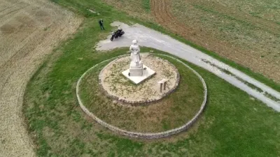
Memorial known as the Basques Monument

No reviews yet
Have you flown here? Share your experience with other pilots.
+ Write the first reviewHistory
1ère moitié 20e siècle Le Monument des Basques, situé entre Hurtebise et Craonne, a été élevé en mémoire de la 36e division d'infanterie en majorité composée de mobilisés originaires des Basses-Pyrénées. Elle combat à plusieurs reprises sur le Chemin des Dames et fait figure de division martyre en raison de l'importance des pertes qu'elle subit. En septembre 1914, la 36e DI tente de conserver les positions françaises sur la crête du Chemin des Dames mais en vain. Du 4 au 6 mai 1917, elle prend d'assaut le plateau de Californie et réussit à l'occuper. Les pertes sont telles que deux brigades doivent être supprimées faute d'effectif. Après une courte période de repos, la 36e DI remonte en ligne et subit une forte contre-attaque allemande les 3 et 4 juin 1917. Le Monument des Basques est dû à l'initiative des anciens combattants du sud-ouest de la France. Les souscriptions publiques et les subventions des communes basques ont financé sa construction. Le monument est inauguré le 30 septembre 1928. Forest, l'architecte et Grange, le sculpteur sont des anciens combattants. Ils ont utilisé la pierre de Souppe, matériau utilisé pour la construction de l'Arc de Triomphe et du Sacré-Coeur de Montmartre. A la base d'un obélisque de 14 mètres, des couronnes de lauriers portent le nom des départements d'origine des combattants de la 36e DI. Les faces latérales sont ornées du monogramme de la division. Au pied de cette stèle, un basque en costume traditionnel embrasse du regard le théâtre des glorieux faits d'armes de la 36e DI.
Map and restricted areas
Open in the main mapRestricted zones
| Zone | Category | Limits | Conditions |
|---|---|---|---|
| Paris 7 | Zone réglementée | 1529 m above sea level → 2907 m above sea level | Vols interdits sauf lorsque the official document of the zone l'autorise explicitement ou avec l'accord du gestionnaire de la zone lorsqu'il est désigné par the official document of the zone |
| Paris 9 | Zone réglementée | 2138 m above sea level → 3821 m above sea level | Vols interdits sauf lorsque the official document of the zone l'autorise explicitement ou avec l'accord du gestionnaire de la zone lorsqu'il est désigné par the official document of the zone |
Nearby aerodromes
Open aerodromes within 25 km of the spot, heliports included, with their distance and direction from the spot. Near an aerodrome, drone flying is prohibited or height-limited: check the UAS zones map.
| Aerodrome | Type | Distance | Elevation |
|---|---|---|---|
| Base ULM Azur | Aerodrome | 7.3 km NE | 73 m |
| Base ULM de Corbeny | Aerodrome | 7.5 km NE | 70 m |
| Base ULM de Ployart | Aerodrome | 8.4 km N | 177 m |
| Laon - Chambry Airfield | Aerodrome | 21 km NW | 78 m |
| Base ULM Avaux - Les Bourdons | Aerodrome | 23 km E | 114 m |
Aviation weather (METAR and TAF)
LFQA – Aérodrome de Reims Prunay VFR
METAR
METAR LFQA 171330Z AUTO 23017G27KT 220V280 9999 FEW043 BKN170 BKN190 17/10 Q0991
- Wind
- 230°, 31 km/h, gusts 50 km/h
- Visibility
- 10 km or more
- Clouds
- Few (1-2/8) at 4,300 ft (1310 m) ; Broken (5-7/8) at 17,000 ft (5180 m) ; Broken (5-7/8) at 19,000 ft (5790 m)
- Temperature
- 17 °C, dew point 10 °C
- QNH
- 991 hPa
- Flight category
- VFR: ceiling > 3,000 ft and visibility > 5 mi
TAF
Weather and Kp index
| Day | Weather | Temp. min. / max. | Wind | Rain | Max Kp |
|---|---|---|---|---|---|
| Tue 17 Nov | Light rain | 11° / 15° | 33 km/h SW | 5.8 mm | 5 |
| Wed 18 Nov | Partly cloudy | 9° / 13° | 31 km/h SW | 3.0 mm | 5 |
| Thu 19 Nov | Light rain | 8° / 12° | 32 km/h SW | 7.6 mm | 3 |
| Fri 20 Nov | Showers | 9° / 12° | 28 km/h SW | 3.3 mm | 3 |
| Sat 21 Nov | Clear sky | 4° / 9° | 25 km/h SW | 1.3 mm | – |
| Sun 22 Nov | Rain | 2° / 5° | 15 km/h E | 6.6 mm | – |
| Mon 23 Nov | Showers | 5° / 11° | 21 km/h W | 1.0 mm | – |
Hour by hour: Tuesday 17 November
| Time | Weather | Temp. | Wind | Rain | Clouds | Kp |
|---|---|---|---|---|---|---|
| 15:00 | Light rain | 15° | 31 km/h SW | 0.1 mm | 97 % | 4 |
| 16:00 | Heavy rain | 14° | 25 km/h SW | 1.8 mm | 100 % | 4 |
| 17:00 | Rain | 11° | 25 km/h SW | 0.6 mm | 99 % | 4 |
| 18:00 | Showers | 11° | 27 km/h SW | 0.4 mm | 86 % | 4 |
| 19:00 | Heavy rain | 11° | 30 km/h SW | 1.0 mm | 98 % | 5 |
| 20:00 | Heavy rain | 11° | 33 km/h SW | 1.2 mm | 100 % | 5 |
| 21:00 | Light rain | 11° | 32 km/h SW | 0.2 mm | 93 % | 5 |
| 22:00 | Light rain | 11° | 30 km/h SW | 0.4 mm | 100 % | 5 |
Hour by hour: Wednesday 18 November
| Time | Weather | Temp. | Wind | Rain | Clouds | Kp |
|---|---|---|---|---|---|---|
| 06:00 | Partly cloudy | 10° | 27 km/h SW | – | 57 % | 4 |
| 07:00 | Partly cloudy | 9° | 26 km/h SW | – | 64 % | 4 |
| 08:00 | Partly cloudy | 9° | 26 km/h SW | – | 80 % | 4 |
| 09:00 | Cloudy | 10° | 27 km/h SW | – | 91 % | 4 |
| 10:00 | Partly cloudy | 11° | 29 km/h SW | – | 65 % | 4 |
| 11:00 | Partly cloudy | 12° | 31 km/h SW | – | 63 % | 4 |
| 12:00 | Partly cloudy | 12° | 30 km/h SW | – | 41 % | 4 |
| 13:00 | Partly cloudy | 13° | 31 km/h SW | – | 58 % | 3 |
| 14:00 | Showers | 13° | 30 km/h W | 0.3 mm | 86 % | 3 |
| 15:00 | Fair | 12° | 27 km/h SW | – | 34 % | 3 |
| 16:00 | Fair | 12° | 24 km/h SW | – | 26 % | 3 |
| 17:00 | Fair | 11° | 20 km/h SW | – | 14 % | 3 |
| 18:00 | Fair | 11° | 22 km/h SW | – | 21 % | 3 |
| 19:00 | Fair | 11° | 21 km/h SW | – | 30 % | 2 |
| 20:00 | Partly cloudy | 10° | 19 km/h SW | – | 53 % | 2 |
| 21:00 | Cloudy | 10° | 19 km/h SW | – | 94 % | 2 |
| 22:00 | Light rain | 10° | 21 km/h SW | 0.1 mm | 100 % | 2 |
Sunrise and sunset
| Day | Dawn | Sunrise | Golden hour | Sunset | Dusk | Day length |
|---|---|---|---|---|---|---|
| Tue 17 Nov | 07:24 | 07:59 | 07:59–08:50 · 16:10–17:01 | 17:01 | 17:36 | 9 h 01 |
| Wed 18 Nov | 07:25 | 08:01 | 08:01–08:52 · 16:09–17:00 | 17:00 | 17:35 | 8 h 59 |
| Thu 19 Nov | 07:27 | 08:02 | 08:02–08:53 · 16:07–16:59 | 16:59 | 17:34 | 8 h 56 |
| Fri 20 Nov | 07:28 | 08:04 | 08:04–08:55 · 16:06–16:58 | 16:58 | 17:33 | 8 h 53 |
| Sat 21 Nov | 07:30 | 08:05 | 08:05–08:57 · 16:05–16:56 | 16:56 | 17:32 | 8 h 51 |
| Sun 22 Nov | 07:31 | 08:07 | 08:07–08:59 · 16:03–16:56 | 16:56 | 17:31 | 8 h 48 |
| Mon 23 Nov | 07:32 | 08:08 | 08:08–09:00 · 16:02–16:55 | 16:55 | 17:30 | 8 h 46 |

Reviews (0)
Log in to review this spot. Log in · Create a free account
No reviews yet. Share yours!