

Chapel of Christ and Cross
No reviews yet
Have you flown here? Share your experience with other pilots.
+ Write the first reviewHistory
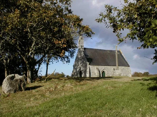
16e siècle ; 18e siècle Il s’agit d’un édifice s’élevant au sommet d’une petite colline et entouré d’un large placître délimité par un talus sur lequel est érigée une croix ancienne. D’apparence homogène et à l’architecture sobre, la chapelle date, pour l’essentiel, de la première moitié du 16e siècle. Elle adopte un plan en équerre associant un vaisseau rectangulaire orienté, à chevet plat, et une chapelle seigneuriale implantée au nord. L’ensemble est bâti en grand appareil de granite. L’élément intérieur le plus remarquable est une tribune en bois polychrome dont la réalisation remonte au 17e siècle ou début du 18e, à partir d’un assemblage de sept panneaux sculptés au 16e siècle figurant des scènes de la Passion et provenant d’un ancien jubé.
Map and restricted areas
Open in the main mapRestricted zones
Nearby aerodromes
Open aerodromes within 25 km of the spot, heliports included, with their distance and direction from the spot. Near an aerodrome, drone flying is prohibited or height-limited: check the UAS zones map.
| Aerodrome | Type | Distance | Elevation |
|---|---|---|---|
| Centre Hospitalier Heliport | Heliport | 14 km NW | 28 m |
| Lannion-Côte de Granit Airport | Airport | 17 km N | 88 m |
Aviation weather (METAR and TAF)
LFRO – Lannion-Côte de Granit Airport IFR
METAR
METAR LFRO 171400Z AUTO 24024G36KT 2600 1100 R29/1300D +RA BR SCT019/// BKN027/// BKN035/// ///CB 12/11 Q0987
- Wind
- 240°, 44 km/h, gusts 67 km/h
- Visibility
- 2.6 km
- Weather
- Rain heavy ; mist
- Clouds
- Scattered (3-4/8) at 1,900 ft (580 m) ; Broken (5-7/8) at 2,700 ft (820 m) ; Broken (5-7/8) at 3,500 ft (1070 m)
- Temperature
- 12 °C, dew point 11 °C
- QNH
- 987 hPa
- Flight category
- IFR: ceiling 500–1,000 ft or visibility 1–3 mi
TAF
Weather and Kp index
Sunrise and sunset
| Day | Dawn | Sunrise | Golden hour | Sunset | Dusk | Day length |
|---|---|---|---|---|---|---|
| Tue 17 Nov | 07:50 | 08:25 | 08:25–09:15 · 16:43–17:32 | 17:32 | 18:07 | 9 h 07 |
| Wed 18 Nov | 07:52 | 08:26 | 08:26–09:16 · 16:41–17:31 | 17:31 | 18:06 | 9 h 04 |
| Thu 19 Nov | 07:53 | 08:28 | 08:28–09:18 · 16:40–17:30 | 17:30 | 18:05 | 9 h 02 |
| Fri 20 Nov | 07:55 | 08:29 | 08:29–09:20 · 16:39–17:29 | 17:29 | 18:04 | 8 h 59 |
| Sat 21 Nov | 07:56 | 08:31 | 08:31–09:21 · 16:37–17:28 | 17:28 | 18:03 | 8 h 57 |
| Sun 22 Nov | 07:57 | 08:32 | 08:32–09:23 · 16:36–17:27 | 17:27 | 18:02 | 8 h 54 |
| Mon 23 Nov | 07:59 | 08:34 | 08:34–09:25 · 16:35–17:26 | 17:26 | 18:01 | 8 h 52 |


Reviews (0)
Log in to review this spot. Log in · Create a free account
No reviews yet. Share yours!