

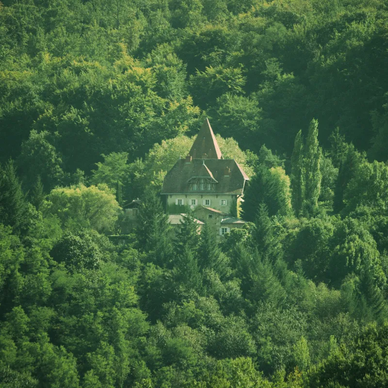
Poudelay Castle
No reviews yet
Have you flown here? Share your experience with other pilots.
+ Write the first reviewHistory
1ère moitié 19e siècle Il s'agissait sans doute d'une maison forte remontant au 15e siècle. Dans son état actuel, cette demeure est surtout marquée par des remaniements de la fin du 19e siècle et du début du 20e siècle. A l'extrémité sud, un faux donjon donne un aspect féodal à l'ensemble. Au nord, le logis est couvert par un toit débordant à croupe, rappelant l'architecture de villégiature de l'époque. L'élément le plus remarquable demeure un papier peint panoramique de la manufacture Dufour, les " Vues d'Italie ", datant des années 1820.
Map and restricted areas
Open in the main mapRestricted zones
| Zone | Category | Limits | Conditions |
|---|---|---|---|
| Zrt Gaudens High | ZRT | FL 175 / FL 185 | SUP AIP 055/26 · Du jeudi 16 avril 2026 au mercredi 12 avril 2028 |
| Zrt Lima 1 | ZRT | FL 195 / FL 285 | SUP AIP 219/26 · Du mardi 20 octobre au jeudi 22 octobre 2026 |
Nearby aerodromes
Open aerodromes within 25 km of the spot, heliports included, with their distance and direction from the spot. Near an aerodrome, drone flying is prohibited or height-limited: check the UAS zones map.
| Aerodrome | Type | Distance | Elevation |
|---|---|---|---|
| Cérizols Balloonport | Balloon port | 4.6 km W | 400 m |
| Aérodrome de Cazères - Palaminy | Aerodrome | 10 km NW | 247 m |
| Altisurface de Balesta Nature | Aerodrome | 11 km W | 425 m |
| Aérodrome de Saint-Girons - Antichan | Airport | 13 km S | 417 m |
| Marmouzet Airfield | Aerodrome | 16 km NE | 320 m |
Aviation weather (METAR and TAF)
No METAR station within 50 km.
Weather and Kp index
| Day | Weather | Temp. min. / max. | Wind | Rain | Max Kp |
|---|---|---|---|---|---|
| Tue 17 Nov | Cloudy | 10° / 13° | 12 km/h E | – | 5 |
| Wed 18 Nov | Clear sky | 10° / 16° | 21 km/h E | 1.7 mm | 5 |
| Thu 19 Nov | Clear sky | 7° / 16° | 30 km/h W | 7.8 mm | 3 |
| Fri 20 Nov | Partly cloudy | 4° / 15° | 16 km/h W | – | 3 |
| Sat 21 Nov | Cloudy | 6° / 16° | 11 km/h E | – | – |
| Sun 22 Nov | Fair | 10° / 14° | 26 km/h W | 0.9 mm | – |
| Mon 23 Nov | Cloudy | 4° / 14° | 8 km/h E | – | – |
Hour by hour: Tuesday 17 November
| Time | Weather | Temp. | Wind | Rain | Clouds | Kp |
|---|---|---|---|---|---|---|
| 15:00 | Cloudy | 13° | 8 km/h E | – | 100 % | 4 |
| 16:00 | Cloudy | 13° | 10 km/h NE | – | 100 % | 4 |
| 17:00 | Cloudy | 13° | 12 km/h E | – | 100 % | 4 |
| 18:00 | Fog | 12° | 10 km/h SE | – | 100 % | 4 |
| 19:00 | Fog | 12° | 8 km/h SE | – | 100 % | 5 |
| 20:00 | Fog | 11° | 9 km/h S | – | 98 % | 5 |
| 21:00 | Fog | 11° | 8 km/h N | – | 100 % | 5 |
| 22:00 | Fog | 11° | 8 km/h S | – | 100 % | 5 |
Hour by hour: Wednesday 18 November
| Time | Weather | Temp. | Wind | Rain | Clouds | Kp |
|---|---|---|---|---|---|---|
| 06:00 | Light rain | 12° | 13 km/h NW | 0.1 mm | 100 % | 4 |
| 07:00 | Rain | 12° | 16 km/h W | 0.7 mm | 100 % | 4 |
| 08:00 | Light rain | 12° | 21 km/h W | 0.2 mm | 100 % | 4 |
| 09:00 | Light rain | 11° | 19 km/h W | 0.1 mm | 100 % | 4 |
| 10:00 | Cloudy | 12° | 17 km/h SW | – | 100 % | 4 |
| 11:00 | Partly cloudy | 13° | 15 km/h W | – | 52 % | 4 |
| 12:00 | Fair | 15° | 16 km/h W | – | 20 % | 4 |
| 13:00 | Clear sky | 16° | 15 km/h W | – | 5 % | 3 |
| 14:00 | Clear sky | 16° | 14 km/h W | – | 11 % | 3 |
| 15:00 | Partly cloudy | 16° | 10 km/h W | – | 66 % | 3 |
| 16:00 | Partly cloudy | 16° | 6 km/h W | – | 91 % | 3 |
| 17:00 | Partly cloudy | 14° | 4 km/h SE | – | 75 % | 3 |
| 18:00 | Partly cloudy | 11° | 7 km/h SE | – | 91 % | 3 |
| 19:00 | Partly cloudy | 11° | 11 km/h SE | – | 96 % | 2 |
| 20:00 | Partly cloudy | 12° | 15 km/h SE | – | 77 % | 2 |
| 21:00 | Cloudy | 11° | 16 km/h SE | – | 94 % | 2 |
| 22:00 | Light rain | 11° | 17 km/h SE | 0.2 mm | 100 % | 2 |
Sunrise and sunset
| Day | Dawn | Sunrise | Golden hour | Sunset | Dusk | Day length |
|---|---|---|---|---|---|---|
| Tue 17 Nov | 07:20 | 07:51 | 07:51–08:34 · 16:47–17:30 | 17:30 | 18:01 | 9 h 39 |
| Wed 18 Nov | 07:21 | 07:52 | 07:52–08:35 · 16:46–17:29 | 17:29 | 18:00 | 9 h 37 |
| Thu 19 Nov | 07:22 | 07:53 | 07:53–08:37 · 16:45–17:29 | 17:29 | 17:59 | 9 h 35 |
| Fri 20 Nov | 07:24 | 07:54 | 07:54–08:38 · 16:44–17:28 | 17:28 | 17:59 | 9 h 33 |
| Sat 21 Nov | 07:25 | 07:56 | 07:56–08:39 · 16:43–17:27 | 17:27 | 17:58 | 9 h 31 |
| Sun 22 Nov | 07:26 | 07:57 | 07:57–08:41 · 16:42–17:26 | 17:26 | 17:57 | 9 h 29 |
| Mon 23 Nov | 07:27 | 07:58 | 07:58–08:42 · 16:42–17:26 | 17:26 | 17:57 | 9 h 27 |

Reviews (0)
Log in to review this spot. Log in · Create a free account
No reviews yet. Share yours!