

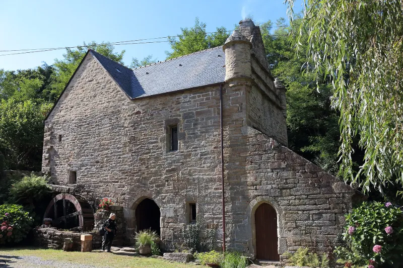
Chef du Bois Water Mill
No reviews yet
Have you flown here? Share your experience with other pilots.
+ Write the first reviewHistory
4e quart 16e siècle ; 18e siècle ; 19e siècle Présumé dater du de la fin du 16e siècle, ce moulin à eau est d'origine sans doute antérieure et de fondation monastique. Il se trouvait sur l'ancienne paroisse de Locamand. Son volume, ses matériaux, deux tourelles d'angle et sa position encaissée, lui confèrent une grande qualité monumentale et l'aspect d'un manoir breton. Moulin à farine, il est bâti en granit en moyen appareil dans les parties basses, et l'architecture, de plan rectangulaire, est à un étage avec d'étroites ouvertures et des portes chanfreinées. Habité par la famille du meunier, il s'accommodait, au début des années 1930, d'une couverture en chaume. Le moulin se raccorde à un canal de dérivation de près de 800 mètres de longueur, à environ 6 km de la source. Son dispositif hydraulique bien préservé date de 1779 et de 1792 (inscriptions en français dans le granit monolithe du noc) ; deux fortes roues chevillées en chêne, de dessus, externes, de 3 m de diamètre, sont placées de part et d'autre des façades barlongues. Elles entraînaient deux paires de meules et un cylindre, installé après la guerre.
Map and restricted areas
Open in the main mapRestricted zones
Nearby aerodromes
Open aerodromes within 25 km of the spot, heliports included, with their distance and direction from the spot. Near an aerodrome, drone flying is prohibited or height-limited: check the UAS zones map.
| Aerodrome | Type | Distance | Elevation |
|---|---|---|---|
| Cornouailles Heliport | Heliport | 14 km NW | 54 m |
| Quimper-Cornouaille Airport | Airport | 18 km W | 91 m |
| Glénan Heliport | Heliport | 22 km S | 0 m |
| Base ULM de Ploballanec | Aerodrome | 25 km SW | 15 m |
Aviation weather (METAR and TAF)
LFRQ – Quimper-Cornouaille Airport MVFR
METAR
METAR LFRQ 171330Z AUTO 22020G32KT 9000 BKN019 BKN029 OVC096 15/12 Q0989 TEMPO 24025G50KT 1400 TSRAGS BKN006 BKN020CB
- Wind
- 220°, 37 km/h, gusts 59 km/h
- Visibility
- 9 km
- Clouds
- Broken (5-7/8) at 1,900 ft (580 m) ; Broken (5-7/8) at 2,900 ft (880 m) ; Overcast (8/8) at 9,600 ft (2930 m)
- Temperature
- 15 °C, dew point 12 °C
- QNH
- 989 hPa
- Flight category
- MVFR: ceiling 1,000–3,000 ft or visibility 3–5 mi
TAF
TAF LFRQ 171100Z 1712/1812 24020G30KT 9999 BKN020 TEMPO 1712/1812 25020G40KT 3000 SHRA BKN012 SCT020CB SCT025TCU PROB40 TEMPO 1712/1716 24025G50KT 1400 TSRAGS BKN006 BKN020CB PROB40 TEMPO 1800/1808 1400 TSRA
| Period (local time) | Change | Wind | Visibility | Weather | Clouds |
|---|---|---|---|---|---|
| 17/11 13:00 → 18/11 13:00 | Initial conditions | 240°, 37 km/h, gusts 56 km/h | 10 km or more | Broken (5-7/8) at 2,000 ft (610 m) | |
| 17/11 13:00 → 18/11 13:00 | Temporarily | 250°, 37 km/h, gusts 74 km/h | 3.0 km | Showers of rain | Broken (5-7/8) at 1,200 ft (370 m) ; Scattered (3-4/8) at 2,000 ft (610 m) (cumulonimbus) ; Scattered (3-4/8) at 2,500 ft (760 m) (towering cumulus) |
| 17/11 13:00 → 17/11 17:00 | Temporarily, probability 40% | 240°, 46 km/h, gusts 93 km/h | 1.4 km | Thunderstorm rain ; thunderstorm small hail | Broken (5-7/8) at 600 ft (180 m) ; Broken (5-7/8) at 2,000 ft (610 m) (cumulonimbus) |
| 18/11 01:00 → 18/11 09:00 | Temporarily, probability 40% | 1.4 km | Thunderstorm rain |
Weather and Kp index
| Day | Weather | Temp. min. / max. | Wind | Rain | Max Kp |
|---|---|---|---|---|---|
| Tue 17 Nov | Heavy rain | 12° / 14° | 58 km/h SW | 4.0 mm | 5 |
| Wed 18 Nov | Fair | 10° / 15° | 45 km/h SW | 12 mm | 5 |
| Thu 19 Nov | Showers | 10° / 13° | 50 km/h W | 7.5 mm | 3 |
| Fri 20 Nov | Clear sky | 10° / 14° | 46 km/h W | 2.5 mm | 3 |
| Sat 21 Nov | Fair | 10° / 14° | 30 km/h SE | 11 mm | – |
| Sun 22 Nov | Light rain | 10° / 13° | 33 km/h W | 11 mm | – |
| Mon 23 Nov | Showers | 9° / 13° | 23 km/h S | 8.1 mm | – |
Hour by hour: Tuesday 17 November
| Time | Weather | Temp. | Wind | Rain | Clouds | Kp |
|---|---|---|---|---|---|---|
| 15:00 | Heavy rain | 14° | 53 km/h SW | 3.3 mm | 100 % | 4 |
| 16:00 | Light rain | 13° | 58 km/h SW | 0.4 mm | 99 % | 4 |
| 17:00 | Showers | 13° | 52 km/h W | 0.2 mm | 58 % | 4 |
| 18:00 | Fair | 13° | 39 km/h W | – | 20 % | 4 |
| 19:00 | Showers | 13° | 37 km/h W | 0.1 mm | 66 % | 5 |
| 20:00 | Clear sky | 12° | 37 km/h W | – | 12 % | 5 |
| 21:00 | Clear sky | 13° | 36 km/h W | – | 4 % | 5 |
| 22:00 | Fair | 13° | 41 km/h W | – | 34 % | 5 |
Hour by hour: Wednesday 18 November
| Time | Weather | Temp. | Wind | Rain | Clouds | Kp |
|---|---|---|---|---|---|---|
| 06:00 | Rain | 11° | 38 km/h W | 0.9 mm | 88 % | 4 |
| 07:00 | Partly cloudy | 11° | 39 km/h W | – | 40 % | 4 |
| 08:00 | Fair | 12° | 41 km/h W | – | 29 % | 4 |
| 09:00 | Showers | 12° | 41 km/h W | 0.3 mm | 62 % | 4 |
| 10:00 | Fair | 12° | 39 km/h W | – | 34 % | 4 |
| 11:00 | Clear sky | 13° | 35 km/h W | – | 5 % | 4 |
| 12:00 | Showers | 14° | 33 km/h SW | 0.1 mm | 15 % | 4 |
| 13:00 | Fair | 14° | 37 km/h SW | – | 16 % | 3 |
| 14:00 | Showers | 15° | 35 km/h SW | 0.5 mm | 79 % | 3 |
| 15:00 | Rain | 13° | 35 km/h SW | 0.9 mm | 100 % | 3 |
| 16:00 | Heavy rain | 13° | 35 km/h SW | 1.8 mm | 99 % | 3 |
| 17:00 | Heavy rain | 12° | 30 km/h SW | 1.6 mm | 100 % | 3 |
| 18:00 | Rain | 12° | 45 km/h SW | 0.5 mm | 100 % | 3 |
| 19:00 | Partly cloudy | 12° | 39 km/h SW | – | 62 % | 2 |
| 20:00 | Rain | 12° | 40 km/h SW | 0.5 mm | 88 % | 2 |
| 21:00 | Showers | 11° | 45 km/h W | 0.4 mm | 77 % | 2 |
| 22:00 | Showers | 10° | 39 km/h W | 0.2 mm | 33 % | 2 |
Sunrise and sunset
| Day | Dawn | Sunrise | Golden hour | Sunset | Dusk | Day length |
|---|---|---|---|---|---|---|
| Tue 17 Nov | 07:51 | 08:25 | 08:25–09:13 · 16:48–17:37 | 17:37 | 18:11 | 9 h 11 |
| Wed 18 Nov | 07:52 | 08:26 | 08:26–09:15 · 16:47–17:36 | 17:36 | 18:10 | 9 h 09 |
| Thu 19 Nov | 07:54 | 08:28 | 08:28–09:17 · 16:45–17:35 | 17:35 | 18:09 | 9 h 06 |
| Fri 20 Nov | 07:55 | 08:29 | 08:29–09:19 · 16:44–17:34 | 17:34 | 18:08 | 9 h 04 |
| Sat 21 Nov | 07:56 | 08:31 | 08:31–09:20 · 16:43–17:33 | 17:33 | 18:07 | 9 h 01 |
| Sun 22 Nov | 07:58 | 08:32 | 08:32–09:22 · 16:42–17:32 | 17:32 | 18:06 | 8 h 59 |
| Mon 23 Nov | 07:59 | 08:34 | 08:34–09:23 · 16:41–17:31 | 17:31 | 18:05 | 8 h 57 |



Reviews (0)
Log in to review this spot. Log in · Create a free account
No reviews yet. Share yours!