

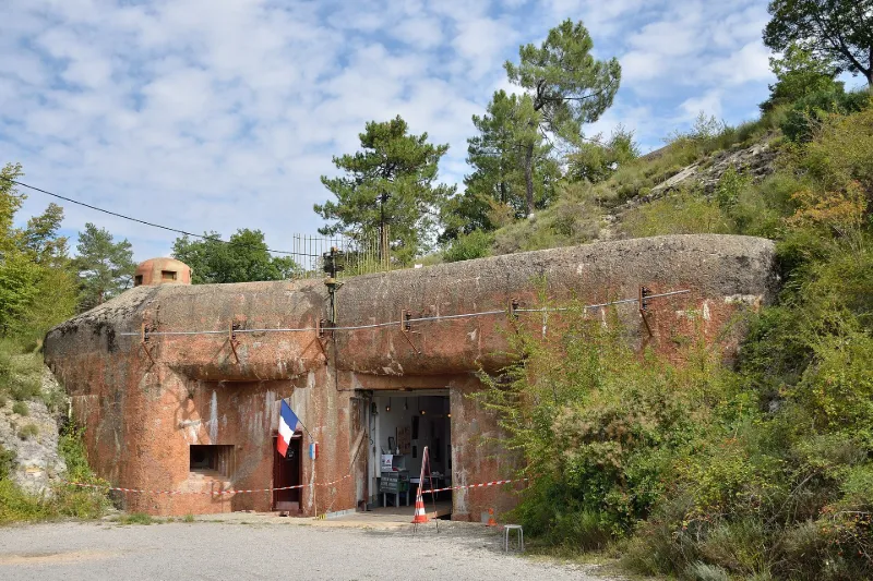
Agaisen Work EO III
No reviews yet
Have you flown here? Share your experience with other pilots.
+ Write the first reviewHistory
20e siècle En 1929, la commission de défense des frontières choisit le site de l’Agaisen pour implanter un ouvrage mixte (artillerie-infanterie) qui aurait pour mission le barrage de la trouée de la Bévéra à Sospel. Le projet d’un ouvrage CORF (commission d’organisation des régions fortifiées) à quatre blocs est approuvé en 1931. Sa construction est, pour l’essentiel, achevée en 1937. Son équipement se poursuit jusqu’à la guerre. L’ouvrage fut particulièrement actif au début de la Seconde guerre mondiale, faisant échec à la tentative d’invasion italienne de juin 1940. Après l’invasion de la zone sud en 1942, il fut occupé par les Italiens puis par les Allemands qui en sabotèrent les installations lors de leur retraite en octobre 1944. Remis en état par les Américains, l’ouvrage participa aux dernières actions de guerre de la ligne Maginot.
Map and restricted areas
Open in the main mapRestricted zones
| Zone | Category | Limits | Conditions |
|---|---|---|---|
| Sospel (06) | Activité de loisirs | 0 m above ground level → 152 m above ground level | Flights reserved for members and guests of the club, under the terms set by the model-aircraft field manager |
Nearby aerodromes
Open aerodromes within 25 km of the spot, heliports included, with their distance and direction from the spot. Near an aerodrome, drone flying is prohibited or height-limited: check the UAS zones map.
| Aerodrome | Type | Distance | Elevation |
|---|---|---|---|
| Casa del Mare Helipad | Heliport | 14 km S | 5 m |
| Avenue Impératrice Eugénie Heliport | Heliport | 15 km S | 36 m |
| Avenue Douine Heliport | Heliport | 15 km S | 44 m |
| Terre-Plein du Larvotto Heliport | Heliport | 16 km S | 6 m |
| Princess Grace Hospital Helipad | Heliport | 18 km S | 103 m |
Aviation weather (METAR and TAF)
LFMN – Nice-Côte d'Azur Airport VFR
METAR
METAR LFMN 171330Z 33010KT 9999 -RA FEW036 OVC100 15/11 Q1003 NOSIG
- Wind
- 330°, 19 km/h
- Visibility
- 10 km or more
- Weather
- Rain light
- Clouds
- Few (1-2/8) at 3,600 ft (1100 m) ; Overcast (8/8) at 10,000 ft (3050 m)
- Temperature
- 15 °C, dew point 11 °C
- QNH
- 1003 hPa
- Flight category
- VFR: ceiling > 3,000 ft and visibility > 5 mi
TAF
TAF LFMN 170800Z 1709/1815 33010KT 9999 BKN035 BECMG 1710/1712 22008KT PROB30 TEMPO 1713/1719 VRB10KT SHRA SCT040TCU BECMG 1719/1721 24018KT
| Period (local time) | Change | Wind | Visibility | Weather | Clouds |
|---|---|---|---|---|---|
| 17/11 10:00 → 17/11 11:00 | Initial conditions | 330°, 19 km/h | 10 km or more | Broken (5-7/8) at 3,500 ft (1070 m) | |
| 17/11 11:00 → 17/11 20:00 | Becoming | 220°, 15 km/h | 10 km or more | Broken (5-7/8) at 3,500 ft (1070 m) | |
| 17/11 14:00 → 17/11 20:00 | Temporarily, probability 30% | Variable, 19 km/h | Showers of rain | Scattered (3-4/8) at 4,000 ft (1220 m) (towering cumulus) | |
| 17/11 20:00 → 18/11 16:00 | Becoming | 240°, 33 km/h | 10 km or more | Broken (5-7/8) at 3,500 ft (1070 m) |
Weather and Kp index
| Day | Weather | Temp. min. / max. | Wind | Rain | Max Kp |
|---|---|---|---|---|---|
| Tue 17 Nov | Heavy rain | 10° / 13° | 12 km/h NW | 3.7 mm | 5 |
| Wed 18 Nov | Fair | 7° / 16° | 24 km/h W | – | 5 |
| Thu 19 Nov | Clear sky | 6° / 16° | 23 km/h W | 11 mm | 3 |
| Fri 20 Nov | Clear sky | 4° / 16° | 13 km/h N | – | 3 |
| Sat 21 Nov | Partly cloudy | 6° / 16° | 5 km/h S | – | – |
| Sun 22 Nov | Clear sky | 7° / 12° | 6 km/h NW | 7.0 mm | – |
| Mon 23 Nov | Fair | 3° / 15° | 5 km/h N | – | – |
Hour by hour: Tuesday 17 November
| Time | Weather | Temp. | Wind | Rain | Clouds | Kp |
|---|---|---|---|---|---|---|
| 15:00 | Heavy rain | 13° | 7 km/h W | 1.2 mm | 100 % | 4 |
| 16:00 | Rain | 12° | 6 km/h W | 0.9 mm | 100 % | 4 |
| 17:00 | Heavy rain | 12° | 5 km/h NW | 1.3 mm | 100 % | 4 |
| 18:00 | Light rain | 11° | 8 km/h NW | 0.3 mm | 100 % | 4 |
| 19:00 | Cloudy | 11° | 9 km/h NW | – | 98 % | 5 |
| 20:00 | Cloudy | 10° | 10 km/h NW | – | 99 % | 5 |
| 21:00 | Partly cloudy | 10° | 12 km/h NW | – | 83 % | 5 |
| 22:00 | Cloudy | 10° | 11 km/h NW | – | 95 % | 5 |
Hour by hour: Wednesday 18 November
| Time | Weather | Temp. | Wind | Rain | Clouds | Kp |
|---|---|---|---|---|---|---|
| 06:00 | Partly cloudy | 13° | 16 km/h NW | – | 80 % | 4 |
| 07:00 | Partly cloudy | 12° | 16 km/h NW | – | 85 % | 4 |
| 08:00 | Partly cloudy | 12° | 18 km/h NW | – | 70 % | 4 |
| 09:00 | Partly cloudy | 13° | 19 km/h NW | – | 49 % | 4 |
| 10:00 | Fair | 14° | 19 km/h W | – | 14 % | 4 |
| 11:00 | Fair | 15° | 24 km/h W | – | 32 % | 4 |
| 12:00 | Fair | 16° | 24 km/h W | – | 38 % | 4 |
| 13:00 | Fair | 16° | 24 km/h W | – | 23 % | 3 |
| 14:00 | Clear sky | 16° | 24 km/h W | – | 9 % | 3 |
| 15:00 | Clear sky | 16° | 21 km/h W | – | 6 % | 3 |
| 16:00 | Clear sky | 15° | 20 km/h W | – | 3 % | 3 |
| 17:00 | Clear sky | 12° | 16 km/h W | – | 2 % | 3 |
| 18:00 | Clear sky | 10° | 12 km/h NW | – | 6 % | 3 |
| 19:00 | Partly cloudy | 8° | 10 km/h NW | – | 42 % | 2 |
| 20:00 | Partly cloudy | 8° | 10 km/h N | – | 84 % | 2 |
| 21:00 | Partly cloudy | 7° | 10 km/h N | – | 70 % | 2 |
| 22:00 | Partly cloudy | 8° | 12 km/h NW | – | 53 % | 2 |
Sunrise and sunset
| Day | Dawn | Sunrise | Golden hour | Sunset | Dusk | Day length |
|---|---|---|---|---|---|---|
| Tue 17 Nov | 06:56 | 07:27 | 07:27–08:11 · 16:19–17:03 | 17:03 | 17:34 | 9 h 35 |
| Wed 18 Nov | 06:57 | 07:29 | 07:29–08:13 · 16:18–17:02 | 17:02 | 17:33 | 9 h 33 |
| Thu 19 Nov | 06:59 | 07:30 | 07:30–08:14 · 16:17–17:01 | 17:01 | 17:32 | 9 h 31 |
| Fri 20 Nov | 07:00 | 07:31 | 07:31–08:16 · 16:16–17:00 | 17:00 | 17:32 | 9 h 29 |
| Sat 21 Nov | 07:01 | 07:33 | 07:33–08:17 · 16:15–17:00 | 17:00 | 17:31 | 9 h 27 |
| Sun 22 Nov | 07:02 | 07:34 | 07:34–08:18 · 16:14–16:59 | 16:59 | 17:30 | 9 h 25 |
| Mon 23 Nov | 07:03 | 07:35 | 07:35–08:20 · 16:13–16:58 | 16:58 | 17:30 | 9 h 23 |
Nearby spots


Other tourist sites nearby
- Notre-Dame-des-Grâces Chapel
- Italy Gate
- Notre-Dame-de-Bon-Coeur Chapel
- Commemorative Plaques Inscribed in the Rock and Rock Walls
- Saint-Jean-la-Rivière Water Intake, Headworks of the Vésubie Canal
- Saint-Blaise Siphon, Remarkable Technical Structure of the Vésubie Canal (also in the commune of Saint-Blaise)
Reviews (0)
Log in to review this spot. Log in · Create a free account
No reviews yet. Share yours!