

Hydroelectric Plant
No reviews yet
Have you flown here? Share your experience with other pilots.
+ Write the first reviewHistory
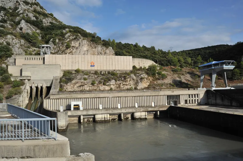
3e quart 20e siècle L'une des vingt-deux centrales de l'aménagement hydroélectrique des bassins de la Durance et du Verdon pendant les années 1950, cette centrale est dessinée par l'architecte Jean Crozet pour EDF. Elle est mise en service en 1959. L'usine, adossée au relief, est du type dit "à toit ouvrant" avec portique extérieur de 120 tonnes de force, circulant au-dessus de la salle des machines. Celle-ci abrite trois turbines de type Kaplan, trois alternateurs triphasés et trois transformateurs triphasés.
Map and restricted areas
Open in the main mapRestricted zones
| Zone | Category | Limits | Conditions |
|---|---|---|---|
| Voltac Luc | Entrainement Militaire | 0 m above ground level → 15241 m above ground level | Pilotage de drones en vue directe : les aéronefs dont la masse est supérieure à 900 grammes sont soumis à notification préalable selon des modalités publiées sur le site www.ecologie.gouv.fr |
| Salon | Zone réglementée | 914 m above sea level → 2602 m above sea level | Vols interdits sauf lorsque the official document of the zone l'autorise explicitement ou avec l'accord du gestionnaire de la zone lorsqu'il est désigné par the official document of the zone |
| Salon | Zone réglementée | 1834 m above sea level → 5040 m above sea level | Vols interdits sauf lorsque the official document of the zone l'autorise explicitement ou avec l'accord du gestionnaire de la zone lorsqu'il est désigné par the official document of the zone |
Nearby aerodromes
Open aerodromes within 25 km of the spot, heliports included, with their distance and direction from the spot. Near an aerodrome, drone flying is prohibited or height-limited: check the UAS zones map.
| Aerodrome | Type | Distance | Elevation |
|---|---|---|---|
| Aérodrome de Vinon | Aerodrome | 12 km NE | 275 m |
| Saint Martin de Castillon | Aerodrome | 21 km NW | 335 m |
| Pays d'Aix Medical Center Heliport | Heliport | 24 km SW | 222 m |
Aviation weather (METAR and TAF)
LFML – Marseille Provence Airport VFR
METAR
METAR LFML 171330Z AUTO 08005KT 9999 ///TCU 17/13 Q1004 TEMPO 4000 SHRA
- Wind
- 080°, 9 km/h
- Visibility
- 10 km or more
- Clouds
- –
- Temperature
- 17 °C, dew point 13 °C
- QNH
- 1004 hPa
- Flight category
- VFR: ceiling > 3,000 ft and visibility > 5 mi
TAF
TAF AMD LFML 171130Z 1711/1815 VRB06KT 9999 BKN024 TX18/1712Z TN13/1806Z PROB40 TEMPO 1711/1719 4000 SHRA SCT070TCU PROB40 TEMPO 1719/1724 BKN008 PROB30 TEMPO 1800/1807 4000 BR PROB40 TEMPO 1808/1813 SHRA SCT070TCU
| Period (local time) | Change | Wind | Visibility | Weather | Clouds |
|---|---|---|---|---|---|
| 17/11 12:00 → 18/11 16:00 | Initial conditions | Variable, 11 km/h | 10 km or more | Broken (5-7/8) at 2,400 ft (730 m) | |
| 17/11 12:00 → 17/11 20:00 | Temporarily, probability 40% | 4.0 km | Showers of rain | Scattered (3-4/8) at 7,000 ft (2130 m) (towering cumulus) | |
| 17/11 20:00 → 18/11 01:00 | Temporarily, probability 40% | Broken (5-7/8) at 800 ft (240 m) | |||
| 18/11 01:00 → 18/11 08:00 | Temporarily, probability 30% | 4.0 km | Mist | ||
| 18/11 09:00 → 18/11 14:00 | Temporarily, probability 40% | Showers of rain | Scattered (3-4/8) at 7,000 ft (2130 m) (towering cumulus) |
Weather and Kp index
| Day | Weather | Temp. min. / max. | Wind | Rain | Max Kp |
|---|---|---|---|---|---|
| Tue 17 Nov | Heavy rain | 11° / 13° | 11 km/h W | 6.4 mm | 5 |
| Wed 18 Nov | Cloudy | 9° / 15° | 18 km/h W | 0.1 mm | 5 |
| Thu 19 Nov | Clear sky | 8° / 14° | 27 km/h W | 7.3 mm | 3 |
| Fri 20 Nov | Clear sky | 6° / 13° | 18 km/h W | – | 3 |
| Sat 21 Nov | Partly cloudy | 6° / 14° | 14 km/h W | – | – |
| Sun 22 Nov | Partly cloudy | 7° / 16° | 18 km/h NW | 4.1 mm | – |
| Mon 23 Nov | Fair | 6° / 13° | 19 km/h NW | – | – |
Hour by hour: Tuesday 17 November
| Time | Weather | Temp. | Wind | Rain | Clouds | Kp |
|---|---|---|---|---|---|---|
| 15:00 | Heavy rain | 13° | 6 km/h NE | 1.1 mm | 100 % | 4 |
| 16:00 | Rain | 12° | 3 km/h SE | 0.8 mm | 100 % | 4 |
| 17:00 | Rain | 12° | 4 km/h W | 0.6 mm | 100 % | 4 |
| 18:00 | Rain | 12° | 6 km/h W | 0.4 mm | 100 % | 4 |
| 19:00 | Rain | 11° | 11 km/h W | 0.9 mm | 100 % | 5 |
| 20:00 | Heavy rain | 12° | 8 km/h W | 1.2 mm | 100 % | 5 |
| 21:00 | Heavy rain | 12° | 9 km/h SW | 1.0 mm | 100 % | 5 |
| 22:00 | Light rain | 11° | 8 km/h W | 0.3 mm | 100 % | 5 |
Hour by hour: Wednesday 18 November
| Time | Weather | Temp. | Wind | Rain | Clouds | Kp |
|---|---|---|---|---|---|---|
| 06:00 | Cloudy | 10° | 13 km/h W | – | 100 % | 4 |
| 07:00 | Light rain | 11° | 17 km/h W | 0.1 mm | 91 % | 4 |
| 08:00 | Cloudy | 11° | 17 km/h W | – | 99 % | 4 |
| 09:00 | Cloudy | 12° | 17 km/h W | – | 100 % | 4 |
| 10:00 | Fog | 13° | 18 km/h W | – | 94 % | 4 |
| 11:00 | Cloudy | 13° | 18 km/h W | – | 95 % | 4 |
| 12:00 | Cloudy | 14° | 18 km/h W | – | 100 % | 4 |
| 13:00 | Cloudy | 14° | 18 km/h W | – | 100 % | 3 |
| 14:00 | Partly cloudy | 14° | 17 km/h W | – | 44 % | 3 |
| 15:00 | Clear sky | 15° | 17 km/h W | – | 1 % | 3 |
| 16:00 | Clear sky | 14° | 16 km/h W | – | 2 % | 3 |
| 17:00 | Clear sky | 13° | 14 km/h W | – | 9 % | 3 |
| 18:00 | Partly cloudy | 11° | 13 km/h W | – | 91 % | 3 |
| 19:00 | Partly cloudy | 11° | 11 km/h W | – | 97 % | 2 |
| 20:00 | Partly cloudy | 10° | 9 km/h W | – | 96 % | 2 |
| 21:00 | Partly cloudy | 10° | 7 km/h W | – | 87 % | 2 |
| 22:00 | Partly cloudy | 9° | 4 km/h S | – | 92 % | 2 |
Sunrise and sunset
| Day | Dawn | Sunrise | Golden hour | Sunset | Dusk | Day length |
|---|---|---|---|---|---|---|
| Tue 17 Nov | 07:03 | 07:34 | 07:34–08:18 · 16:27–17:11 | 17:11 | 17:42 | 9 h 36 |
| Wed 18 Nov | 07:04 | 07:35 | 07:35–08:19 · 16:26–17:10 | 17:10 | 17:41 | 9 h 34 |
| Thu 19 Nov | 07:05 | 07:37 | 07:37–08:21 · 16:25–17:09 | 17:09 | 17:40 | 9 h 32 |
| Fri 20 Nov | 07:07 | 07:38 | 07:38–08:22 · 16:24–17:08 | 17:08 | 17:39 | 9 h 30 |
| Sat 21 Nov | 07:08 | 07:39 | 07:39–08:23 · 16:23–17:07 | 17:07 | 17:39 | 9 h 28 |
| Sun 22 Nov | 07:09 | 07:40 | 07:40–08:25 · 16:22–17:07 | 17:07 | 17:38 | 9 h 26 |
| Mon 23 Nov | 07:10 | 07:42 | 07:42–08:26 · 16:21–17:06 | 17:06 | 17:37 | 9 h 24 |

Reviews (0)
Log in to review this spot. Log in · Create a free account
No reviews yet. Share yours!