

Comper Castle
No reviews yet
Have you flown here? Share your experience with other pilots.
+ Write the first reviewHistory
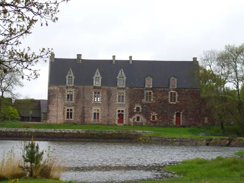
Comper, qui se trouve aux confins nord-ouest de la forêt de Paimpont, est entouré de cinq étangs, dont le Grand Etang, qui alimentait les douves du château. La première mention historique est de 1301. Suite à l'avènement de Jean de Montfort au duché de Bretagne sous le nom de Jean IV, des seigneurs bretons, sous la conduite de du Guesclin soutenu par le roi de France, détruisent les châteaux de Mauron, Gaël, Comper, Bontavant et Montfort. En 1375, Montfort et Comper sont relevés par les comtes de Gaël-Montfort ; les ruines de la forteresse qui subsistent dateraient de cette reconstruction. Le château de Comper est composé de deux parties : l'enceinte et le manoir. Le registre de l'abbé Guillotin à la fin du 18e siècle décrit la forme quadrangulaire de l'enceinte avec une tour à chaque angle du château ; de cette enceinte, il reste les deux tours encadrant l'entrée, la substructure de la tour sud à côté du pont et une partie de la tour est. Le manoir a été édifié à l'emplacement de la courtine sud-est après 1620 par Mathurin de Rosmadec ; la terrasse près de l'étang a été réalisée en 1699 ; l'escalier et la partie sud du manoir ont été reconstruits en 1866 par Armand de Charette. Aujourd'hui encore, Comper est un rendez-vous de chasse et de pêche et la ferme, la forêt et les étangs sont toujours exploités.
Map and restricted areas
Open in the main mapRestricted zones
| Zone | Category | Limits | Conditions |
|---|---|---|---|
| Argoat | Zone réglementée | 3053 m above sea level → 6259 m above sea level | Vols interdits sauf lorsque the official document of the zone l'autorise explicitement ou avec l'accord du gestionnaire de la zone lorsqu'il est désigné par the official document of the zone |
Nearby aerodromes
Open aerodromes within 25 km of the spot, heliports included, with their distance and direction from the spot. Near an aerodrome, drone flying is prohibited or height-limited: check the UAS zones map.
| Aerodrome | Type | Distance | Elevation |
|---|---|---|---|
| Coëtquidan Air Base | Aerodrome | 14 km S | 130 m |
| Ploërmel Loyat Airfield | Aerodrome | 17 km SW | 72 m |
Aviation weather (METAR and TAF)
LFRN – Rennes-Saint-Jacques Airport MVFR
METAR
METAR LFRN 171400Z AUTO 23020G32KT 190V260 9999 BKN029 OVC034 16/11 Q0990 TEMPO 23025G45KT 1400 TSRAGS BKN008 BKN020CB
- Wind
- 230°, 37 km/h, gusts 59 km/h
- Visibility
- 10 km or more
- Clouds
- Broken (5-7/8) at 2,900 ft (880 m) ; Overcast (8/8) at 3,400 ft (1040 m)
- Temperature
- 16 °C, dew point 11 °C
- QNH
- 990 hPa
- Flight category
- MVFR: ceiling 1,000–3,000 ft or visibility 3–5 mi
TAF
TAF LFRN 171100Z 1712/1812 23017G30KT 9999 BKN020 TEMPO 1712/1719 23020G35KT 3000 SHRA BKN012 SCT020CB SCT025TCU PROB40 TEMPO 1714/1718 23025G45KT 1400 TSRAGS BKN008 BKN020CB PROB40 TEMPO 1719/1812 3000 SHRA BKN012 BKN020TCU SCT025CB PROB30 TEMPO 1800/1806 1400 TSRA
| Period (local time) | Change | Wind | Visibility | Weather | Clouds |
|---|---|---|---|---|---|
| 17/11 13:00 → 18/11 13:00 | Initial conditions | 230°, 31 km/h, gusts 56 km/h | 10 km or more | Broken (5-7/8) at 2,000 ft (610 m) | |
| 17/11 13:00 → 17/11 20:00 | Temporarily | 230°, 37 km/h, gusts 65 km/h | 3.0 km | Showers of rain | Broken (5-7/8) at 1,200 ft (370 m) ; Scattered (3-4/8) at 2,000 ft (610 m) (cumulonimbus) ; Scattered (3-4/8) at 2,500 ft (760 m) (towering cumulus) |
| 17/11 15:00 → 17/11 19:00 | Temporarily, probability 40% | 230°, 46 km/h, gusts 83 km/h | 1.4 km | Thunderstorm rain ; thunderstorm small hail | Broken (5-7/8) at 800 ft (240 m) ; Broken (5-7/8) at 2,000 ft (610 m) (cumulonimbus) |
| 17/11 20:00 → 18/11 13:00 | Temporarily, probability 40% | 3.0 km | Showers of rain | Broken (5-7/8) at 1,200 ft (370 m) ; Broken (5-7/8) at 2,000 ft (610 m) (towering cumulus) ; Scattered (3-4/8) at 2,500 ft (760 m) (cumulonimbus) | |
| 18/11 01:00 → 18/11 07:00 | Temporarily, probability 30% | 1.4 km | Thunderstorm rain |
Weather and Kp index
| Day | Weather | Temp. min. / max. | Wind | Rain | Max Kp |
|---|---|---|---|---|---|
| Tue 17 Nov | Rain | 11° / 14° | 40 km/h SW | 3.8 mm | 5 |
| Wed 18 Nov | Fair | 10° / 14° | 30 km/h S | 5.6 mm | 5 |
| Thu 19 Nov | Light rain | 8° / 13° | 32 km/h SW | 0.1 mm | 3 |
| Fri 20 Nov | Partly cloudy | 9° / 13° | 26 km/h W | 0.5 mm | 3 |
| Sat 21 Nov | Cloudy | 7° / 12° | 19 km/h SE | 2.0 mm | – |
| Sun 22 Nov | Light rain | 9° / 11° | 25 km/h W | 11 mm | – |
| Mon 23 Nov | Fair | 6° / 13° | 17 km/h SW | 0.6 mm | – |
Hour by hour: Tuesday 17 November
| Time | Weather | Temp. | Wind | Rain | Clouds | Kp |
|---|---|---|---|---|---|---|
| 15:00 | Rain | 14° | 40 km/h SW | 1.0 mm | 99 % | 4 |
| 16:00 | Heavy rain | 12° | 34 km/h SW | 1.4 mm | 100 % | 4 |
| 17:00 | Heavy rain | 12° | 28 km/h SW | 1.1 mm | 100 % | 4 |
| 18:00 | Light rain | 12° | 33 km/h SW | 0.2 mm | 98 % | 4 |
| 19:00 | Partly cloudy | 12° | 28 km/h W | – | 43 % | 5 |
| 20:00 | Fair | 11° | 25 km/h W | – | 16 % | 5 |
| 21:00 | Fair | 11° | 24 km/h SW | – | 28 % | 5 |
| 22:00 | Fair | 11° | 24 km/h SW | – | 19 % | 5 |
Hour by hour: Wednesday 18 November
| Time | Weather | Temp. | Wind | Rain | Clouds | Kp |
|---|---|---|---|---|---|---|
| 06:00 | Partly cloudy | 10° | 25 km/h SW | – | 58 % | 4 |
| 07:00 | Partly cloudy | 10° | 25 km/h SW | – | 46 % | 4 |
| 08:00 | Partly cloudy | 10° | 25 km/h SW | – | 45 % | 4 |
| 09:00 | Partly cloudy | 10° | 26 km/h SW | – | 45 % | 4 |
| 10:00 | Fair | 11° | 26 km/h SW | – | 28 % | 4 |
| 11:00 | Fair | 12° | 27 km/h SW | – | 13 % | 4 |
| 12:00 | Fair | 13° | 26 km/h SW | – | 15 % | 4 |
| 13:00 | Fair | 14° | 28 km/h SW | – | 20 % | 3 |
| 14:00 | Fair | 14° | 30 km/h SW | – | 28 % | 3 |
| 15:00 | Partly cloudy | 14° | 28 km/h SW | – | 78 % | 3 |
| 16:00 | Cloudy | 13° | 25 km/h SW | – | 100 % | 3 |
| 17:00 | Heavy rain | 13° | 25 km/h SW | 1.2 mm | 98 % | 3 |
| 18:00 | Heavy rain | 11° | 26 km/h SW | 1.3 mm | 100 % | 3 |
| 19:00 | Heavy rain | 11° | 26 km/h S | 1.7 mm | 100 % | 2 |
| 20:00 | Light rain | 11° | 30 km/h S | 0.2 mm | 100 % | 2 |
| 21:00 | Showers | 11° | 28 km/h SW | 0.2 mm | 83 % | 2 |
| 22:00 | Rain | 11° | 27 km/h SW | 0.9 mm | 94 % | 2 |
Sunrise and sunset
| Day | Dawn | Sunrise | Golden hour | Sunset | Dusk | Day length |
|---|---|---|---|---|---|---|
| Tue 17 Nov | 07:44 | 08:18 | 08:18–09:07 · 16:40–17:29 | 17:29 | 18:03 | 9 h 10 |
| Wed 18 Nov | 07:46 | 08:20 | 08:20–09:09 · 16:39–17:28 | 17:28 | 18:02 | 9 h 08 |
| Thu 19 Nov | 07:47 | 08:21 | 08:21–09:11 · 16:38–17:27 | 17:27 | 18:01 | 9 h 05 |
| Fri 20 Nov | 07:48 | 08:23 | 08:23–09:12 · 16:36–17:26 | 17:26 | 18:00 | 9 h 03 |
| Sat 21 Nov | 07:50 | 08:24 | 08:24–09:14 · 16:35–17:25 | 17:25 | 17:59 | 9 h 00 |
| Sun 22 Nov | 07:51 | 08:26 | 08:26–09:16 · 16:34–17:24 | 17:24 | 17:59 | 8 h 58 |
| Mon 23 Nov | 07:52 | 08:27 | 08:27–09:17 · 16:33–17:23 | 17:23 | 17:58 | 8 h 56 |
Reviews (0)
Log in to review this spot. Log in · Create a free account
No reviews yet. Share yours!