

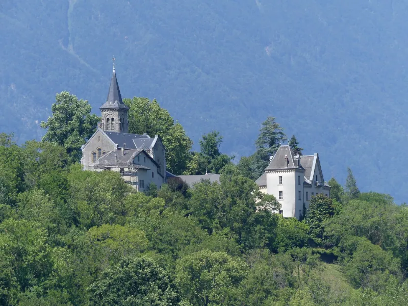
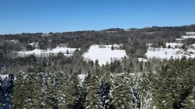
Bettonnet Castle
No reviews yet
Have you flown here? Share your experience with other pilots.
+ Write the first reviewHistory
Ancienne maison forte, qui fait partie de la seigneurie de Chamoux au 17e siècle. Transformation du château entre 1717 et 1719 et aménagement d'un jardin en 1722 : allée de charmes, jardin clos à trois niveaux, terrasses, verger. Ensemble du domaine très remanié au 19e siècle (dans les années 1850-1860) et au début du 20e siècle, mais il présente encore l'essentiel des éléments figurant sur le plan de 1722. Au rez-de-chaussée, subsistent cinq pièces à décor des 18e et 19e siècles.
Map and restricted areas
Open in the main mapRestricted zones
| Zone | Category | Limits | Conditions |
|---|---|---|---|
| Zrt/zdt Riviera | ZRT/ZDT | From about 14,950 m to about 16,750 m above sea level | SUP AIP 233/24 · Du 16 janvier 2025 au 13 janvier 2027 |
Nearby aerodromes
Open aerodromes within 25 km of the spot, heliports included, with their distance and direction from the spot. Near an aerodrome, drone flying is prohibited or height-limited: check the UAS zones map.
| Aerodrome | Type | Distance | Elevation |
|---|---|---|---|
| La Fullie | Heliport | 13 km N | 1,394 m |
| Albertville Airfield | Aerodrome | 16 km NE | 315 m |
| Aérodrome de Chambéry Challes-les-Eaux | Aerodrome | 17 km W | 297 m |
| Saint Rémy de Maurienne | Aerodrome | 18 km SE | 426 m |
| Altisurface de Valmorel | Aerodrome | 19 km SE | 1,930 m |
Aviation weather (METAR and TAF)
LFLB – Chambéry-Savoie Airport VFR
METAR
METAR LFLB 171400Z AUTO 21011KT 190V260 9999 BKN060 BKN070 OVC200 15/11 Q1002
- Wind
- 210°, 20 km/h
- Visibility
- 10 km or more
- Clouds
- Broken (5-7/8) at 6,000 ft (1830 m) ; Broken (5-7/8) at 7,000 ft (2130 m) ; Overcast (8/8) at 20,000 ft (6100 m)
- Temperature
- 15 °C, dew point 11 °C
- QNH
- 1002 hPa
- Flight category
- VFR: ceiling > 3,000 ft and visibility > 5 mi
TAF
Weather and Kp index
| Day | Weather | Temp. min. / max. | Wind | Rain | Max Kp |
|---|---|---|---|---|---|
| Tue 17 Nov | Cloudy | 12° / 13° | 8 km/h SE | 1.3 mm | 5 |
| Wed 18 Nov | Showers | 9° / 12° | 7 km/h S | 21 mm | 5 |
| Thu 19 Nov | Showers | 8° / 10° | 8 km/h E | 29 mm | 3 |
| Fri 20 Nov | Light rain | 6° / 10° | 7 km/h E | 29 mm | 3 |
| Sat 21 Nov | Clear sky | 6° / 13° | 3 km/h E | 3.8 mm | – |
| Sun 22 Nov | Showers | 3° / 10° | 6 km/h E | 24 mm | – |
| Mon 23 Nov | Fair | 3° / 12° | 4 km/h E | 2.2 mm | – |
Hour by hour: Tuesday 17 November
| Time | Weather | Temp. | Wind | Rain | Clouds | Kp |
|---|---|---|---|---|---|---|
| 15:00 | Cloudy | 13° | 6 km/h NE | – | 91 % | 4 |
| 16:00 | Cloudy | 13° | 5 km/h E | – | 100 % | 4 |
| 17:00 | Cloudy | 13° | 4 km/h NE | – | 88 % | 4 |
| 18:00 | Light rain | 12° | 4 km/h E | 0.1 mm | 94 % | 4 |
| 19:00 | Rain | 12° | 5 km/h SE | 0.4 mm | 98 % | 5 |
| 20:00 | Light rain | 13° | 8 km/h SE | 0.2 mm | 98 % | 5 |
| 21:00 | Rain | 13° | 7 km/h SE | 0.5 mm | 100 % | 5 |
| 22:00 | Partly cloudy | 12° | 8 km/h SE | – | 86 % | 5 |
Hour by hour: Wednesday 18 November
| Time | Weather | Temp. | Wind | Rain | Clouds | Kp |
|---|---|---|---|---|---|---|
| 06:00 | Heavy rain | 11° | 4 km/h NE | 2.1 mm | 97 % | 4 |
| 07:00 | Heavy rain | 10° | 5 km/h NW | 1.5 mm | 98 % | 4 |
| 08:00 | Showers | 10° | 5 km/h E | 0.6 mm | 77 % | 4 |
| 09:00 | Showers | 11° | 5 km/h NW | 0.4 mm | 63 % | 4 |
| 10:00 | Showers | 11° | 5 km/h W | 1.0 mm | 77 % | 4 |
| 11:00 | Showers | 12° | 7 km/h NW | 1.3 mm | 80 % | 4 |
| 12:00 | Showers | 12° | 6 km/h SW | 1.0 mm | 64 % | 4 |
| 13:00 | Showers | 12° | 7 km/h S | 0.6 mm | 73 % | 3 |
| 14:00 | Showers | 12° | 6 km/h S | 1.3 mm | 77 % | 3 |
| 15:00 | Showers | 12° | 6 km/h S | 1.3 mm | 85 % | 3 |
| 16:00 | Rain | 11° | 7 km/h SE | 0.6 mm | 98 % | 3 |
| 17:00 | Rain | 11° | 3 km/h SE | 0.6 mm | 99 % | 3 |
| 18:00 | Light rain | 11° | 3 km/h E | 0.2 mm | 99 % | 3 |
| 19:00 | Cloudy | 11° | 4 km/h E | – | 99 % | 2 |
| 20:00 | Cloudy | 11° | 5 km/h E | – | 89 % | 2 |
| 21:00 | Cloudy | 10° | 4 km/h E | – | 97 % | 2 |
| 22:00 | Cloudy | 9° | 5 km/h E | – | 88 % | 2 |
Sunrise and sunset
| Day | Dawn | Sunrise | Golden hour | Sunset | Dusk | Day length |
|---|---|---|---|---|---|---|
| Tue 17 Nov | 07:05 | 07:37 | 07:37–08:23 · 16:18–17:03 | 17:03 | 17:36 | 9 h 26 |
| Wed 18 Nov | 07:06 | 07:38 | 07:38–08:24 · 16:17–17:02 | 17:02 | 17:35 | 9 h 23 |
| Thu 19 Nov | 07:07 | 07:40 | 07:40–08:26 · 16:15–17:01 | 17:01 | 17:34 | 9 h 21 |
| Fri 20 Nov | 07:09 | 07:41 | 07:41–08:27 · 16:14–17:01 | 17:01 | 17:33 | 9 h 19 |
| Sat 21 Nov | 07:10 | 07:42 | 07:42–08:29 · 16:13–17:00 | 17:00 | 17:32 | 9 h 17 |
| Sun 22 Nov | 07:11 | 07:44 | 07:44–08:30 · 16:12–16:59 | 16:59 | 17:32 | 9 h 15 |
| Mon 23 Nov | 07:12 | 07:45 | 07:45–08:32 · 16:11–16:58 | 16:58 | 17:31 | 9 h 13 |
Reviews (0)
Log in to review this spot. Log in · Create a free account
No reviews yet. Share yours!