

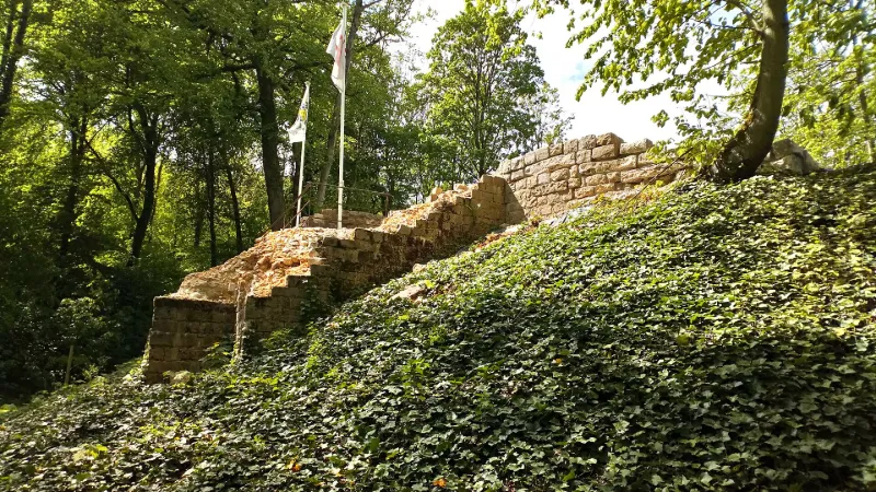
Feudal Motte
No reviews yet
Have you flown here? Share your experience with other pilots.
+ Write the first reviewHistory
L'intérêt porté à cette motte castrale, type de construction se développant entre les 10ème et 12ème siècles, résulte de la combinaison entre l'investissement d'une association locale et les recherches archéologiques menées sur ce site, ainsi valorisé du point de vue touristique et scientifique. Des fouilles archéologiques ont révélé une tour associée à une courtine et à des bâtiments, notamment des caves. La motte fut construite en grès. Des systèmes de canalisation d'eau ont été retrouvés ainsi qu'une partie de la levée d'enceinte de la basse-cour.
Map and restricted areas
Open in the main mapRestricted zones
| Zone | Category | Limits | Conditions |
|---|---|---|---|
| Zrt Opal | ZRT | From about 14,950 m to about 16,750 m above sea level | SUP AIP 233/24 · Du 16 janvier 2025 au 13 janvier 2027 |
| ZRT AMIENS (PPS uniquement) | ZRT | From about 4,100 m to about 4,400 m above sea level | SUP AIP 053/26 · Du jeudi 16 avril 2026 au mercredi 12 avril 2028 |
| ZRT AMIENS HIGH (PPS uniquement) | ZRT | From about 6,250 m to about 6,550 m above sea level | SUP AIP 053/26 · Du jeudi 16 avril 2026 au mercredi 12 avril 2028 |
Nearby aerodromes
Open aerodromes within 25 km of the spot, heliports included, with their distance and direction from the spot. Near an aerodrome, drone flying is prohibited or height-limited: check the UAS zones map.
| Aerodrome | Type | Distance | Elevation |
|---|---|---|---|
| Centre Hospitalier Heliport | Heliport | 15 km NW | 72 m |
| Centre Hospitalier Universitaire Nord Heliport | Heliport | 18 km SW | 49 m |
| Albert-Bray Airport | Aerodrome | 19 km E | 111 m |
| Aérodrome d'Amiens-Glisy | Airport | 19 km S | 63 m |
| Centre Hospitalier Sud Heliport | Heliport | 23 km SW | 61 m |
Aviation weather (METAR and TAF)
LFAQ – Albert-Bray Airport VFR
METAR
METAR LFAQ 171400Z AUTO 23018KT 9999 BKN046 BKN056 OVC100 14/09 Q0987 TEMPO VRB30G40KT 4000 SHRA OVC012CB
- Wind
- 230°, 33 km/h
- Visibility
- 10 km or more
- Clouds
- Broken (5-7/8) at 4,600 ft (1400 m) ; Broken (5-7/8) at 5,600 ft (1710 m) ; Overcast (8/8) at 10,000 ft (3050 m)
- Temperature
- 14 °C, dew point 9 °C
- QNH
- 987 hPa
- Flight category
- VFR: ceiling > 3,000 ft and visibility > 5 mi
TAF
TAF LFAQ 171400Z 1715/1724 26020G30KT 9999 OVC030 TEMPO 1715/1724 4000 SHRA BKN020TCU PROB40 TEMPO 1715/1724 VRB30G40KT 2000 -TSRA OVC012CB PROB30 TEMPO 1716/1724 1400 -TSRAGS
| Period (local time) | Change | Wind | Visibility | Weather | Clouds |
|---|---|---|---|---|---|
| 17/11 16:00 → 18/11 01:00 | Initial conditions | 260°, 37 km/h, gusts 56 km/h | 10 km or more | Overcast (8/8) at 3,000 ft (910 m) | |
| 17/11 16:00 → 18/11 01:00 | Temporarily | 4.0 km | Showers of rain | Broken (5-7/8) at 2,000 ft (610 m) (towering cumulus) | |
| 17/11 16:00 → 18/11 01:00 | Temporarily, probability 40% | Variable, 56 km/h, gusts 74 km/h | 2.0 km | Thunderstorm rain light | Overcast (8/8) at 1,200 ft (370 m) (cumulonimbus) |
| 17/11 17:00 → 18/11 01:00 | Temporarily, probability 30% | 1.4 km | Thunderstorm rain light ; thunderstorm small hail light |
Weather and Kp index
Sunrise and sunset
| Day | Dawn | Sunrise | Golden hour | Sunset | Dusk | Day length |
|---|---|---|---|---|---|---|
| Tue 17 Nov | 07:31 | 08:06 | 08:06–08:58 · 16:12–17:04 | 17:04 | 17:40 | 8 h 57 |
| Wed 18 Nov | 07:32 | 08:08 | 08:08–09:00 · 16:11–17:03 | 17:03 | 17:39 | 8 h 54 |
| Thu 19 Nov | 07:34 | 08:09 | 08:09–09:02 · 16:09–17:02 | 17:02 | 17:38 | 8 h 52 |
| Fri 20 Nov | 07:35 | 08:11 | 08:11–09:04 · 16:08–17:01 | 17:01 | 17:37 | 8 h 49 |
| Sat 21 Nov | 07:36 | 08:13 | 08:13–09:05 · 16:07–16:59 | 16:59 | 17:36 | 8 h 46 |
| Sun 22 Nov | 07:38 | 08:14 | 08:14–09:07 · 16:05–16:58 | 16:58 | 17:35 | 8 h 44 |
| Mon 23 Nov | 07:39 | 08:16 | 08:16–09:09 · 16:04–16:57 | 16:57 | 17:34 | 8 h 41 |

Reviews (0)
Log in to review this spot. Log in · Create a free account
No reviews yet. Share yours!