

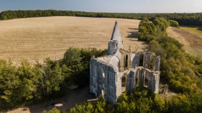
Marmande Castle
No reviews yet
Have you flown here? Share your experience with other pilots.
+ Write the first reviewHistory
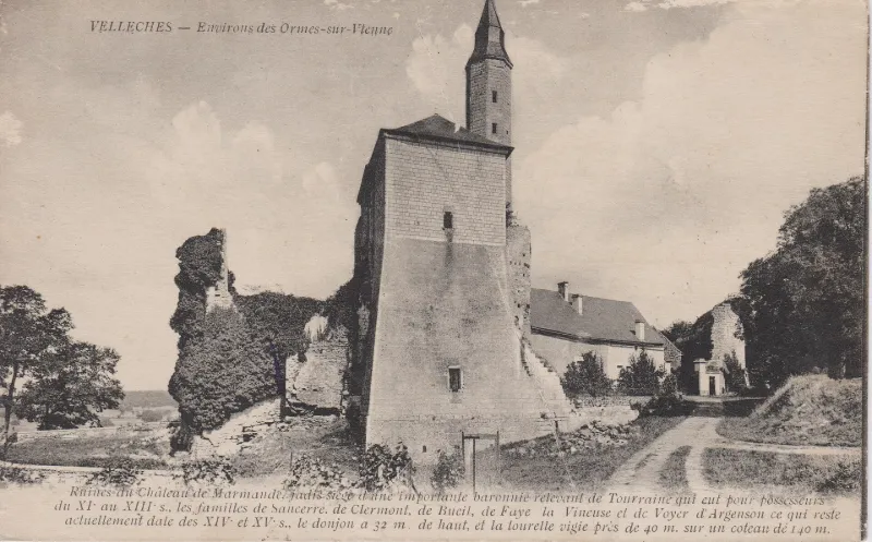
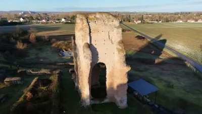
L'implantation géographique du château est assez habituelle puisque la construction s'est effectuée sur un éperon rocheux. Le château présente un intérêt historique par l'ancienneté de son implantation et par les grandes familles de France qui l'ont possédé. Les éléments architecturaux qui subsistent sont de grande qualité et reflètent l'évolution d'une forteresse du 11e au 17e siècles.
Map and restricted areas
Open in the main mapRestricted zones
Nearby aerodromes
Open aerodromes within 25 km of the spot, heliports included, with their distance and direction from the spot. Near an aerodrome, drone flying is prohibited or height-limited: check the UAS zones map.
| Aerodrome | Type | Distance | Elevation |
|---|---|---|---|
| Centre Hospitalier Heliport | Heliport | 13 km S | 84 m |
| Aérodrome de Châtellerault-Targé | Aerodrome | 19 km S | 63 m |
Aviation weather (METAR and TAF)
LFBI – Poitiers-Biard Airport MVFR
METAR
METAR LFBI 171400Z AUTO 23023G33KT 9999 BKN024 BKN029 OVC039 16/12 Q0998 BECMG 4500 -RA BKN020TCU
- Wind
- 230°, 43 km/h, gusts 61 km/h
- Visibility
- 10 km or more
- Clouds
- Broken (5-7/8) at 2,400 ft (730 m) ; Broken (5-7/8) at 2,900 ft (880 m) ; Overcast (8/8) at 3,900 ft (1190 m)
- Temperature
- 16 °C, dew point 12 °C
- QNH
- 998 hPa
- Flight category
- MVFR: ceiling 1,000–3,000 ft or visibility 3–5 mi
TAF
TAF LFBI 171100Z 1712/1812 24015KT 9999 OVC020 BECMG 1712/1715 24015G25KT PROB30 TEMPO 1712/1715 4500 -SHRA BKN014 SCT025TCU BECMG 1715/1718 22020G35KT 4500 -RA BKN020TCU TEMPO 1718/1721 24030G40KT 2500 TSRA BKN012 BKN020CB BECMG 1719/1722 26015G25KT 9999 NSW SCT020 BKN040 TEMPO 1801/1812 4500 -SHRA SCT035CB PROB30 TEMPO 1805/1809 2500 -TSRAGS BKN020CB
| Period (local time) | Change | Wind | Visibility | Weather | Clouds |
|---|---|---|---|---|---|
| 17/11 13:00 → 18/11 13:00 | Initial conditions | 240°, 28 km/h | 10 km or more | Overcast (8/8) at 2,000 ft (610 m) | |
| 17/11 13:00 → 17/11 16:00 | Becoming | 240°, 28 km/h, gusts 46 km/h | 10 km or more | Overcast (8/8) at 2,000 ft (610 m) | |
| 17/11 13:00 → 17/11 16:00 | Temporarily, probability 30% | 4.5 km | Showers of rain light | Broken (5-7/8) at 1,400 ft (430 m) ; Scattered (3-4/8) at 2,500 ft (760 m) (towering cumulus) | |
| 17/11 16:00 → 17/11 20:00 | Becoming | 220°, 37 km/h, gusts 65 km/h | 4.5 km | Rain light | Broken (5-7/8) at 2,000 ft (610 m) (towering cumulus) |
| 17/11 19:00 → 17/11 22:00 | Temporarily | 240°, 56 km/h, gusts 74 km/h | 2.5 km | Thunderstorm rain | Broken (5-7/8) at 1,200 ft (370 m) ; Broken (5-7/8) at 2,000 ft (610 m) (cumulonimbus) |
| 17/11 20:00 → 18/11 13:00 | Becoming | 260°, 28 km/h, gusts 46 km/h | 10 km or more | No significant weather | Scattered (3-4/8) at 2,000 ft (610 m) ; Broken (5-7/8) at 4,000 ft (1220 m) |
| 18/11 02:00 → 18/11 13:00 | Temporarily | 4.5 km | Showers of rain light | Scattered (3-4/8) at 3,500 ft (1070 m) (cumulonimbus) | |
| 18/11 06:00 → 18/11 10:00 | Temporarily, probability 30% | 2.5 km | Thunderstorm rain light ; thunderstorm small hail light | Broken (5-7/8) at 2,000 ft (610 m) (cumulonimbus) |
Weather and Kp index
Sunrise and sunset
| Day | Dawn | Sunrise | Golden hour | Sunset | Dusk | Day length |
|---|---|---|---|---|---|---|
| Tue 17 Nov | 07:31 | 08:04 | 08:04–08:51 · 16:34–17:22 | 17:22 | 17:55 | 9 h 17 |
| Wed 18 Nov | 07:32 | 08:05 | 08:05–08:53 · 16:33–17:21 | 17:21 | 17:54 | 9 h 15 |
| Thu 19 Nov | 07:34 | 08:07 | 08:07–08:55 · 16:32–17:20 | 17:20 | 17:53 | 9 h 12 |
| Fri 20 Nov | 07:35 | 08:08 | 08:08–08:56 · 16:31–17:19 | 17:19 | 17:52 | 9 h 10 |
| Sat 21 Nov | 07:36 | 08:10 | 08:10–08:58 · 16:30–17:18 | 17:18 | 17:52 | 9 h 08 |
| Sun 22 Nov | 07:37 | 08:11 | 08:11–08:59 · 16:29–17:17 | 17:17 | 17:51 | 9 h 06 |
| Mon 23 Nov | 07:39 | 08:12 | 08:12–09:01 · 16:28–17:16 | 17:16 | 17:50 | 9 h 03 |
Reviews (0)
Log in to review this spot. Log in · Create a free account
No reviews yet. Share yours!