

The Fortress of Thil
1 pilot review
“Bonjour Attention ,le propriétaire neveux pas que l'on survole sa propriété , je me suis f…” — villermontois, 6 years ago
Read the reviews + Write my reviewDescription
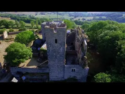
Thil Fortress - Vic sous Thil (21) The first known member of this family is Miles de Thil, who founded the priory of Précy-sous-Thil in 1007. From the 11th century, Thil was a viscounty, on the same footing as Semur-en-Auxois and Villaines. It kept this status until 1310, when it was raised to a county under the Duchy of Burgundy. Around 1340, Jean de Thil was appointed hereditary constable of the Duchy of Burgundy.
https://fr.wikipedia.org/wiki/Ch%C3%A2teau_de_Thil
Music: Two Steps From Hell - Compass Note: - I am not the creator of this music. All rights belong to their respective owners. This video was made for entertainment purposes only. If you like the music, support these artists by purchasing a license for their music.
Forteresse de Thil - Vic sous Thil (21) N47.38622 E4.33645
Today, the castle appears as an ovoid enceinte, comprising a reduit and a lower courtyard. Building studies have identified different phases of construction from the 13th to the 16th century.
From the 13th century, ruins include the remains of a residence with a storeroom and, probably, a watch tower. A chapel dates from 1085. At the end of the 14th century, the construction of a residence tower and a habitable building redefined the space creating what is now referred to as the reduit. This configuration was maintained in the 15th and 16th centuries with the construction of a new building and the rebuilding of the enceinte. Over the centuries, the site improved its residential qualities while safeguarding its defensive structures.
https://en.wikipedia.org/wiki/Ch%C3%A2teau_de_Thil
Music : Two Steps From Hell - Compass Note:- I'm not the creator of this Music, All rights belongs to respective owners. This video is purely fan-made, it's done for entertainment purposes only. Please support these bands and artists by either purchasing or licensing their music. Have fun
Map and restricted areas
Open in the main mapNearby aerodromes
Open aerodromes within 25 km of the spot, heliports included, with their distance and direction from the spot. Near an aerodrome, drone flying is prohibited or height-limited: check the UAS zones map.
| Aerodrome | Type | Distance | Elevation | Difference |
|---|---|---|---|---|
| Semur En Auxois Airfield | Aerodrome | 11 km N | 321 m | spot 147 m higher |
| Centre Hospitalier Heliport | Heliport | 12 km N | 292 m | spot 177 m higher |
| Saulieu Liernais Airfield | Aerodrome | 17 km S | 525 m | spot 57 m lower |
| Pouilly Maconge Airport | Aerodrome | 25 km SE | 430 m | spot 38 m higher |
Aviation weather (METAR and TAF)
No METAR station within 50 km.
Weather and Kp index
Sunrise and sunset
| Day | Dawn | Sunrise | Golden hour | Sunset | Dusk | Day length |
|---|---|---|---|---|---|---|
| Sat 21 Nov | 07:22 | 07:56 | 07:56–08:45 · 16:12–17:01 | 17:01 | 17:35 | 9 h 05 |
| Sun 22 Nov | 07:23 | 07:57 | 07:57–08:46 · 16:11–17:00 | 17:00 | 17:34 | 9 h 03 |
| Mon 23 Nov | 07:24 | 07:59 | 07:59–08:48 · 16:10–17:00 | 17:00 | 17:34 | 9 h 00 |
| Tue 24 Nov | 07:26 | 08:00 | 08:00–08:49 · 16:09–16:59 | 16:59 | 17:33 | 8 h 58 |
| Wed 25 Nov | 07:27 | 08:01 | 08:01–08:51 · 16:08–16:58 | 16:58 | 17:32 | 8 h 56 |
| Thu 26 Nov | 07:28 | 08:03 | 08:03–08:52 · 16:07–16:57 | 16:57 | 17:32 | 8 h 54 |
| Fri 27 Nov | 07:29 | 08:04 | 08:04–08:54 · 16:07–16:57 | 16:57 | 17:31 | 8 h 52 |


Reviews
Log in to review this spot. Log in · Create a free account
villermontois
Bonjour Attention ,le propriétaire neveux pas que l'on survole sa propriété , je me suis fait rappeler a l'ordre le 6septembre 2020. A bon entendeur...