

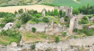
Puilaurens Castle
No reviews yet
Have you flown here? Share your experience with other pilots.
+ Write the first reviewDescription
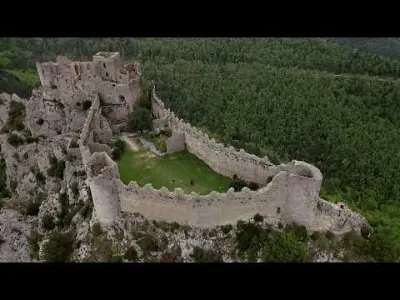
Chateau de Puilaurens Lapradelle-Puilaurens (11) N42.8037, E2.2994
Around 1250, the castle passed into the hands of the French crown. In a letter of August 1255, Louis IX ordered the seneschal of Carcassonne to fortify the castle. Saint Louis had it reinforced to defend Languedoc against Spanish incursions. The Treaty of Corbeil in 1258 made the castle one of the defensive fortresses facing Aragon. It then became one of the "Five Sons of Carcassonne", along with the castles of Quéribus, Peyrepertuse, Termes and Aguilar, all perched on top of "impregnable" rocky peaks. A garrison led by Odon de Monteuil, with a chaplain and 25 sergeants, occupied the castle of Puilaurens in 1259. Consolidation and fortification works continued under Philip the Bold from 1270 to 1285. The castle went on to withstand several Aragonese attacks and remained the southernmost fortress of France. https://fr.wikipedia.org/wiki/Ch%C3%A2teau_de_Puilaurens
Music: Two Steps From Hell - Never Back Down Note: - I am not the creator of this music. All rights belong to their respective owners. This video was made for entertainment purposes only. If you like the music, support these artists by purchasing a license for their music.
Castle of Puilaurens Lapradelle-Puilaurens (11) N42.8037, E2.2994
The Château de Puilaurens (also Puylaurens; in Occitan: lo Castèl de Puèg-Laurenç) is one of the so-called Cathar castles in what is now the South of France. It is located in the commune of Lapradelle-Puilaurens in the Aude département. The castle stands on a spur of rock above the Boulzane Valley and the villages of Lapradelle and Puilaurens. There is a path from Axat to the castle. The castle here had belonged to the Abbey of Saint-Michel de Cuxa before it was acquired by the Queen of Aragon in 1162. As Aragonese property it was outside the territory ravaged by the Crusaders during the Cathar wars. Like Queribus it therefore provided a refuge for those fleeing from the invading forces. Those who took refuge there included both Cathars and faidits, that is to say those who had forfeited their property because of their opposition to the invaders. These faidits included high nobles, such as Guillaume de Peyrepertuse.Puilaurens was ceded to the French some time before 1255. After 1258 its possession by the French crown was ratified by the Treaty of Corbeil, when the Aragonese border was moved south. In 1260, it was garrisoned by 25 sergeants. It was taken by Spanish troops in 1635, but lost all strategic importance after the Treaty of the Pyrenees in 1659 when the border was moved even further south to its present position along the crest of the Pyrenees. Numerous Cathar deacons sought refuge here after the fall of Montsegur. It is thought that the castle was finally forced to surrender (probably around the same time as Queribus) c.1255. https://en.wikipedia.org/wiki/Puilaurens_Castle
Music : Two Steps From Hell - Never Back Down Note:- I'm not the creator of this Music, All rights belongs to respective owners. This video is purely fan-made, it's done for entertainment purposes only. Please support these bands and artists by either purchasing or licensing their music. Have fun
Map and restricted areas
Open in the main mapNearby aerodromes
Open aerodromes within 25 km of the spot, heliports included, with their distance and direction from the spot. Near an aerodrome, drone flying is prohibited or height-limited: check the UAS zones map.
| Aerodrome | Type | Distance | Elevation | Difference |
|---|---|---|---|---|
| Altiport du Col de la Marrano | Aerodrome | 19 km SW | 2,000 m | spot 1,346 m lower |
| Puivert Airfield | Aerodrome | 23 km NW | 490 m | spot 164 m higher |
Aviation weather (METAR and TAF)
LFMK – Carcassonne Airport VFR
METAR
METAR LFMK 211030Z AUTO 08009KT CAVOK 14/10 Q1019 NOSIG
- Wind
- 080°, 17 km/h
- Visibility
- 10 km or more
- Clouds
- –
- Temperature
- 14 °C, dew point 10 °C
- QNH
- 1019 hPa
- Flight category
- VFR: ceiling > 3,000 ft and visibility > 5 mi
TAF
TAF LFMK 210800Z 2109/2209 08010KT CAVOK BECMG 2113/2115 BKN020 PROB40 TEMPO 2115/2123 09015G25KT BKN014 BECMG 2123/2201 BKN009 FM220600 28020G40KT 9999 BKN030 TEMPO 2206/2209 4000 SHRA SCT035CB
| Period (local time) | Change | Wind | Visibility | Weather | Clouds |
|---|---|---|---|---|---|
| 21/11 10:00 → 21/11 14:00 | Initial conditions | 080°, 19 km/h | 10 km or more | No significant weather | No significant cloud |
| 21/11 14:00 → 22/11 00:00 | Becoming | 080°, 19 km/h | 10 km or more | No significant weather | Broken (5-7/8) at 2,000 ft (610 m) |
| 21/11 16:00 → 22/11 00:00 | Temporarily, probability 40% | 090°, 28 km/h, gusts 46 km/h | Broken (5-7/8) at 1,400 ft (430 m) | ||
| 22/11 00:00 → 22/11 07:00 | Becoming | 080°, 19 km/h | 10 km or more | No significant weather | Broken (5-7/8) at 900 ft (270 m) |
| 22/11 07:00 → 22/11 10:00 | From | 280°, 37 km/h, gusts 74 km/h | 10 km or more | Broken (5-7/8) at 3,000 ft (910 m) | |
| 22/11 07:00 → 22/11 10:00 | Temporarily | 4.0 km | Showers of rain | Scattered (3-4/8) at 3,500 ft (1070 m) (cumulonimbus) |
Weather and Kp index
Sunrise and sunset
| Day | Dawn | Sunrise | Golden hour | Sunset | Dusk | Day length |
|---|---|---|---|---|---|---|
| Sat 21 Nov | 07:19 | 07:50 | 07:50–08:34 · 16:40–17:23 | 17:23 | 17:54 | 9 h 33 |
| Sun 22 Nov | 07:20 | 07:51 | 07:51–08:35 · 16:39–17:23 | 17:23 | 17:53 | 9 h 31 |
| Mon 23 Nov | 07:22 | 07:53 | 07:53–08:36 · 16:38–17:22 | 17:22 | 17:53 | 9 h 29 |
| Tue 24 Nov | 07:23 | 07:54 | 07:54–08:38 · 16:37–17:21 | 17:21 | 17:52 | 9 h 27 |
| Wed 25 Nov | 07:24 | 07:55 | 07:55–08:39 · 16:37–17:21 | 17:21 | 17:52 | 9 h 25 |
| Thu 26 Nov | 07:25 | 07:56 | 07:56–08:40 · 16:36–17:20 | 17:20 | 17:51 | 9 h 24 |
| Fri 27 Nov | 07:26 | 07:57 | 07:57–08:41 · 16:35–17:20 | 17:20 | 17:51 | 9 h 22 |


Reviews
Log in to review this spot. Log in · Create a free account
No reviews yet. Share yours!