

LE VILLAGE DES DAMNES
No reviews yet
Have you flown here? Share your experience with other pilots.
+ Write the first reviewDescription
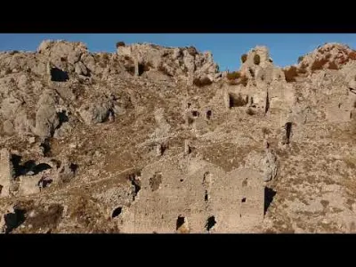
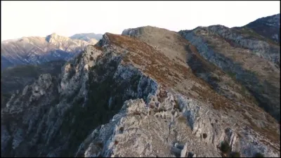
THE VILLAGE OF ROCCA SPAVIERA known as the village of the damned It will be difficult to imagine that at its peak, Rocca Sparvièra had up to 350 inhabitants, the community having an administration, a seigniory, a notary, a parish priest ... Rocca Sparvièra, located about thirty kilometres north of Nice, stands its ruins in the grey rock above the Col Saint Michel. This ghost village, in a wilderness setting, is marked by bloody legends where crime and anthropophagy mingle, stimulated by revenge. In the Middle Ages, this place would have been cursed by Queen Joan who would have been served her murdered children at Christmas Eve dinner. Later, during the wars of the Revolution, the Barbets (resistance fighters from Nice), taking refuge in the ruins, will make French soldiers eat the heart of the murderous officer of one of their fathers. The village, dominated by the remains of its castle, clings on to a rocky ridge that watches over the pass, a necessary passage for an inter-valley road. It's a good hour's walk to get there. About fifty ruined buildings are piled up in an enclosure with traces of an oven and a cistern. Vaulted cellars are still standing. To the north-east, the remains of the enclosure are completed by the remains of the seigneurial dwelling with mullioned windows. A sort of collapsed postern opened to the north of the enclosure. The large facades overlooking the east side of the Engarvin path date back to the 16th century. The only one remaining intact on a platform is the chapel of Saint Michael, restored in 1924 on the structures of the parish church. Let's go back to the origins of Rocca Sparvièra who appears for the first time in history in two 12th century chartres listing the parishes dependent on the bishopric of Nice. On March 6, 1271, one of the members of the illustrious Niçoise family of Riquier pays tribute to the sovereign, they will be co-lords of Rocca Sparvièra. In 1271 the village has 150 inhabitants and its parish church is already dedicated to St. Michael (Sant Michele). The castle is mentioned in 1358 in the contract of allegiance and acquired with its fiefdom for 700 gold florins by Pierre Marquesan di Nizza. In 1364, Queen Joan of Naples raised the fief to the rank of barony, but a plague of locusts destroyed the crops. The misery continued to such an extent that in 1376 the small community was declared insolvent. At the Nice forfeit of 1388, the local nobles opposed the new Savoyard power except for Pierre Marquesan who was granted a special pension of 200 gold florins by the Red Count (Amédée VII). He then opposed his protector, accused of high treason, and his property was confiscated in 1391. Dispersed, it will be officially reinvested from the fiefdoms of Coaraze and Rocca Sparvièra in 1399. The Marquesan family then kept the seigneury until 1781. But a fatal fate seems to be befalling this unfortunate village, which was the victim of a series of plague epidemics in the 16th century that killed part of the population. In addition, a series of dreadful earthquakes will destroy some of the houses, leading to the beginning of its abandonment. The progressive abandonment of this commune which would have counted up to 350 souls before these upheavals, with a communal administration and even a notary, will be spread out throughout the 17th century. If in 1690 a few die-hards still cling to the ruins, ten years later, only the priest and his servant would still reside there before resigning themselves to leaving in 1723. References: http://freerider06.over-blog.com/article-le-village-des-damnes-la-malediction-de-la-reine-3-102425504.html
Map and restricted areas
Open in the main mapNearby aerodromes
Open aerodromes within 25 km of the spot, heliports included, with their distance and direction from the spot. Near an aerodrome, drone flying is prohibited or height-limited: check the UAS zones map.
| Aerodrome | Type | Distance | Elevation | Difference |
|---|---|---|---|---|
| Casa del Mare Helipad | Heliport | 20 km SE | 5 m | spot 1,076 m higher |
| Terre-Plein du Larvotto Heliport | Heliport | 20 km SE | 6 m | spot 1,075 m higher |
| Princess Grace Hospital Helipad | Heliport | 21 km SE | 103 m | spot 978 m higher |
| Avenue Impératrice Eugénie Heliport | Heliport | 21 km SE | 36 m | spot 1,045 m higher |
| Monaco Heliport | Heliport | 21 km SE | 6 m | spot 1,075 m higher |
Aviation weather (METAR and TAF)
LFMN – Nice-Côte d'Azur Airport VFR
METAR
METAR LFMN 211030Z 05005KT CAVOK 17/09 Q1016 NOSIG
- Wind
- 050°, 9 km/h
- Visibility
- 10 km or more
- Clouds
- –
- Temperature
- 17 °C, dew point 9 °C
- QNH
- 1016 hPa
- Flight category
- VFR: ceiling > 3,000 ft and visibility > 5 mi
TAF
TAF LFMN 210800Z 2109/2215 VRB02KT CAVOK PROB40 2113/2121 25010KT BECMG 2121/2123 34010KT TEMPO 2123/2210 4000 RA BKN014 SCT030TCU BECMG 2210/2214 25018G30KT
| Period (local time) | Change | Wind | Visibility | Weather | Clouds |
|---|---|---|---|---|---|
| 21/11 10:00 → 21/11 22:00 | Initial conditions | Variable, 4 km/h | 10 km or more | No significant weather | No significant cloud |
| 21/11 14:00 → 21/11 22:00 | probability 40% | 250°, 19 km/h | |||
| 21/11 22:00 → 22/11 11:00 | Becoming | 340°, 19 km/h | 10 km or more | No significant weather | No significant cloud |
| 22/11 00:00 → 22/11 11:00 | Temporarily | 4.0 km | Rain | Broken (5-7/8) at 1,400 ft (430 m) ; Scattered (3-4/8) at 3,000 ft (910 m) (towering cumulus) | |
| 22/11 11:00 → 22/11 16:00 | Becoming | 250°, 33 km/h, gusts 56 km/h | 10 km or more | No significant weather | No significant cloud |
Weather and Kp index
| Day | Weather | Temp. min. / max. | Wind | Rain | Max Kp |
|---|---|---|---|---|---|
| Sat 21 Nov | Partly cloudy | 6° / 15° | 7 km/h NW | – | 2 |
| Sun 22 Nov | Partly cloudy | 5° / 13° | 24 km/h W | 14 mm | 2 |
| Mon 23 Nov | Clear sky | 3° / 13° | 22 km/h NW | – | 4 |
| Tue 24 Nov | Cloudy | 4° / 11° | 10 km/h N | 0.7 mm | 2 |
| Wed 25 Nov | Rain | 3° / 5° | 12 km/h N | 16 mm | – |
| Thu 26 Nov | Partly cloudy | 2° / 9° | 7 km/h N | 8.5 mm | – |
| Fri 27 Nov | Clear sky | -3° / 10° | 5 km/h N | – | – |
Hour by hour: Saturday 21 November
| Time | Weather | Temp. | Wind | Rain | Clouds | Kp |
|---|---|---|---|---|---|---|
| 11:00 | Partly cloudy | 13° | 7 km/h NW | – | 93 % | 2 |
| 12:00 | Partly cloudy | 15° | 5 km/h SE | – | 80 % | 2 |
| 13:00 | Partly cloudy | 15° | 6 km/h S | – | 56 % | 1 |
| 14:00 | Fair | 15° | 6 km/h S | – | 13 % | 1 |
| 15:00 | Fair | 14° | 5 km/h S | – | 24 % | 1 |
| 16:00 | Fair | 12° | 3 km/h S | – | 37 % | 2 |
| 17:00 | Partly cloudy | 10° | 3 km/h E | – | 47 % | 2 |
| 18:00 | Partly cloudy | 8° | 4 km/h N | – | 63 % | 2 |
| 19:00 | Partly cloudy | 7° | 3 km/h N | – | 64 % | 2 |
| 20:00 | Partly cloudy | 6° | 4 km/h N | – | 44 % | 2 |
| 21:00 | Partly cloudy | 6° | 5 km/h N | – | 79 % | 2 |
| 22:00 | Partly cloudy | 6° | 5 km/h N | – | 56 % | 2 |
Hour by hour: Sunday 22 November
| Time | Weather | Temp. | Wind | Rain | Clouds | Kp |
|---|---|---|---|---|---|---|
| 06:00 | Heavy rain | 7° | 6 km/h N | 1.5 mm | 100 % | 2 |
| 07:00 | Heavy rain | 8° | 7 km/h N | 1.6 mm | 100 % | 2 |
| 08:00 | Heavy rain | 8° | 6 km/h N | 2.5 mm | 100 % | 2 |
| 09:00 | Heavy rain | 8° | 6 km/h N | 2.8 mm | 100 % | 2 |
| 10:00 | Heavy rain | 8° | 6 km/h N | 1.5 mm | 100 % | 2 |
| 11:00 | Heavy rain | 10° | 4 km/h N | 1.0 mm | 88 % | 2 |
| 12:00 | Partly cloudy | 10° | 7 km/h NW | – | 66 % | 2 |
| 13:00 | Partly cloudy | 12° | 12 km/h W | – | 59 % | 2 |
| 14:00 | Fair | 13° | 19 km/h W | – | 28 % | 2 |
| 15:00 | Clear sky | 12° | 21 km/h W | – | 12 % | 2 |
| 16:00 | Fair | 11° | 24 km/h W | – | 25 % | 2 |
| 17:00 | Fair | 9° | 23 km/h W | – | 22 % | 2 |
| 18:00 | Fair | 8° | 23 km/h W | – | 17 % | 2 |
| 19:00 | Clear sky | 7° | 22 km/h NW | – | 9 % | 2 |
| 20:00 | Fair | 7° | 21 km/h NW | – | 16 % | 2 |
| 21:00 | Fair | 6° | 21 km/h NW | – | 29 % | 2 |
| 22:00 | Fair | 6° | 20 km/h NW | – | 25 % | 2 |
Sunrise and sunset
| Day | Dawn | Sunrise | Golden hour | Sunset | Dusk | Day length |
|---|---|---|---|---|---|---|
| Sat 21 Nov | 07:02 | 07:33 | 07:33–08:18 · 16:16–17:00 | 17:00 | 17:32 | 9 h 27 |
| Sun 22 Nov | 07:03 | 07:34 | 07:34–08:19 · 16:15–16:59 | 16:59 | 17:31 | 9 h 25 |
| Mon 23 Nov | 07:04 | 07:36 | 07:36–08:21 · 16:14–16:59 | 16:59 | 17:30 | 9 h 23 |
| Tue 24 Nov | 07:05 | 07:37 | 07:37–08:22 · 16:13–16:58 | 16:58 | 17:30 | 9 h 21 |
| Wed 25 Nov | 07:06 | 07:38 | 07:38–08:23 · 16:12–16:58 | 16:58 | 17:29 | 9 h 19 |
| Thu 26 Nov | 07:07 | 07:39 | 07:39–08:25 · 16:12–16:57 | 16:57 | 17:29 | 9 h 17 |
| Fri 27 Nov | 07:09 | 07:41 | 07:41–08:26 · 16:11–16:56 | 16:56 | 17:28 | 9 h 15 |



Reviews
Log in to review this spot. Log in · Create a free account
No reviews yet. Share yours!