

Tancarville Bridge

No reviews yet
Have you flown here? Share your experience with other pilots.
+ Write the first reviewDescription
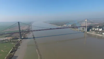
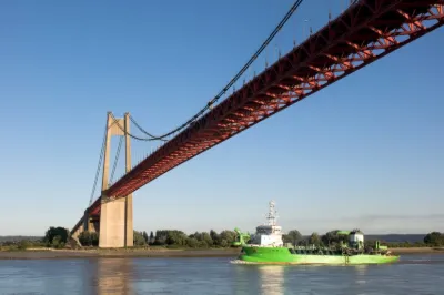
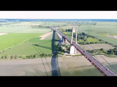
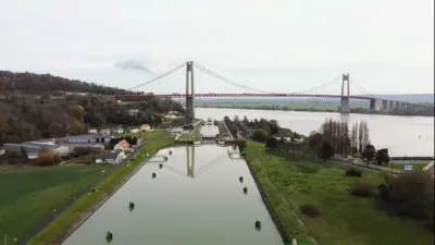
As early as 1931, the continuous increase in ferry traffic on the estuary prompted the Chamber of Commerce and Industry of Le Havre (CCI) to think about a bridge over the Seine. On 7 December 1933, the CCI decided to build a "road bridge" around the Hode-Berville ferry. On November 27, 1935, the preliminary project for a suspension bridge, located in Tancarville, was finalized and adopted the next day by deliberation on November 28, 1935, by the Chamber of Commerce and Industry, which requested the concession for its construction and operation. The decision to build it was recorded in a law of 11 December 1940, signed by Marshal Pétain in Vichy and declaring the project to be of public utility1. In November 1951, the CCI, the contracting authority, launched an international competition and fourteen groups of companies submitted their projects in August 1952. Project management is entrusted to the Ponts et Chaussées of the Seine-Maritime department. In 1954, the Chamber of Commerce and Industry, assisted by the Civil Engineers, chose the project to be carried out2,3. Begun on 16 November 19554, the bridge was commissioned on 2 July 1959, on schedule4. Until the opening date of the Normandy Bridge, it was the closest bridge to the Seine estuary. Its opening led to the disappearance of the Hode ferry linking Berville-sur-Mer in the Eure to the Hode in the Seine-Maritime. This ferry, a war pity, was reputed to be "inconvenient "4. Technical data In 1959, the structure had the longest central span in Europe: 608 metres, which to this day remains the national record, and two side spans of 176 metres each. The total weight of the framework is 7500 tons. Its pylons are 123 metres high and support an average load of 6,000 tonnes. Due to the marshy nature of the land, the foundation of the left bank tower is 28 metres deep, so that it rests on a compact soil. The one on the right bank pylon is 18 metres deep. The cables are connected to two anchor blocks, the heaviest of which weighs 36,000 tonnes and has dimensions similar to those of the Arc de Triomphe. Wind tunnel tests have verified the structure's resistance to all kinds of wind oscillations5. It was one of the first projects of this importance to be completed without a fatal accident.
Map and restricted areas
Open in the main mapNearby aerodromes
Open aerodromes within 25 km of the spot, heliports included, with their distance and direction from the spot. Near an aerodrome, drone flying is prohibited or height-limited: check the UAS zones map.
| Aerodrome | Type | Distance | Elevation |
|---|---|---|---|
| Aérodrome du Havre - Saint-Romain | Aerodrome | 11 km NW | 129 m |
| Usine Renault Heliport | Heliport | 12 km W | 5 m |
| La Ferme Saint Siméon Heliport | Heliport | 18 km W | 31 m |
| Hopital Jacques Monod Heliport | Heliport | 21 km W | 12 m |
Aviation weather (METAR and TAF)
LFRG – Deauville-Saint-Gatien Airport LIFR
METAR
METAR LFRG 210630Z AUTO 20005KT 8000 BKN003 BKN008 OVC012 08/08 Q1017 TEMPO 0300 FG VV///
- Wind
- 200°, 9 km/h
- Visibility
- 8 km
- Clouds
- Broken (5-7/8) at 300 ft (90 m) ; Broken (5-7/8) at 800 ft (240 m) ; Overcast (8/8) at 1,200 ft (370 m)
- Temperature
- 8 °C, dew point 8 °C
- QNH
- 1017 hPa
- Flight category
- LIFR: ceiling < 500 ft or visibility < 1 mi
TAF
TAF LFRG 210500Z 2106/2115 VRB05KT 3000 BR BKN003 TEMPO 2106/2110 0300 FG VV/// BECMG 2110/2112 9999 NSW BKN006 BECMG 2112/2114 14010KT BKN012
| Period (local time) | Change | Wind | Visibility | Weather | Clouds |
|---|---|---|---|---|---|
| 21/11 07:00 → 21/11 11:00 | Initial conditions | Variable, 9 km/h | 3.0 km | Mist | Broken (5-7/8) at 300 ft (90 m) |
| 21/11 07:00 → 21/11 11:00 | Temporarily | 300 m | Fog | ||
| 21/11 11:00 → 21/11 13:00 | Becoming | Variable, 9 km/h | 10 km or more | No significant weather | Broken (5-7/8) at 600 ft (180 m) |
| 21/11 13:00 → 21/11 16:00 | Becoming | 140°, 19 km/h | 10 km or more | No significant weather | Broken (5-7/8) at 1,200 ft (370 m) |
Weather and Kp index
Sunrise and sunset
| Day | Dawn | Sunrise | Golden hour | Sunset | Dusk | Day length |
|---|---|---|---|---|---|---|
| Sat 21 Nov | 07:43 | 08:18 | 08:18–09:10 · 16:18–17:10 | 17:10 | 17:45 | 8 h 51 |
| Sun 22 Nov | 07:44 | 08:20 | 08:20–09:12 · 16:16–17:09 | 17:09 | 17:44 | 8 h 48 |
| Mon 23 Nov | 07:46 | 08:21 | 08:21–09:14 · 16:15–17:08 | 17:08 | 17:43 | 8 h 46 |
| Tue 24 Nov | 07:47 | 08:23 | 08:23–09:16 · 16:14–17:07 | 17:07 | 17:43 | 8 h 43 |
| Wed 25 Nov | 07:48 | 08:24 | 08:24–09:17 · 16:13–17:06 | 17:06 | 17:42 | 8 h 41 |
| Thu 26 Nov | 07:50 | 08:26 | 08:26–09:19 · 16:12–17:05 | 17:05 | 17:41 | 8 h 39 |
| Fri 27 Nov | 07:51 | 08:27 | 08:27–09:21 · 16:11–17:04 | 17:04 | 17:41 | 8 h 37 |


Reviews
Log in to review this spot. Log in · Create a free account
No reviews yet. Share yours!