

Unusual
Roussillon
4 pilot reviews
“Hello, est ce que c'est possible dorénavant de faire des prises de vue là-bas maintenant ?” — ivedroneit, 4 years ago
Read the reviews + Write my reviewDescription
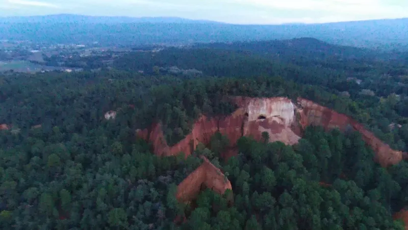
Former ochre quarry near Roussillon. Video made in the evening, it lacks brightness but you can discover this place. I'll try to do it again during the day. Good viewing.
Map and restricted areas
Open in the main mapNearby aerodromes
Open aerodromes within 25 km of the spot, heliports included, with their distance and direction from the spot. Near an aerodrome, drone flying is prohibited or height-limited: check the UAS zones map.
| Aerodrome | Type | Distance | Elevation | Difference |
|---|---|---|---|---|
| Hôtel La Coquillade Heliport | Heliport | 2.5 km S | 249 m | spot 74 m higher |
| Saint Martin de Castillon | Aerodrome | 20 km E | 335 m | spot 12 m lower |
| Aérodrome de Carpentras | Aerodrome | 23 km NW | 120 m | spot 203 m higher |
Aviation weather (METAR and TAF)
LFMV – Avignon-Caumont Airport VFR
METAR
METAR LFMV 211000Z AUTO VRB02KT CAVOK 11/08 Q1021 NOSIG
- Wind
- Variable, 4 km/h
- Visibility
- 10 km or more
- Clouds
- –
- Temperature
- 11 °C, dew point 8 °C
- QNH
- 1021 hPa
- Flight category
- VFR: ceiling > 3,000 ft and visibility > 5 mi
TAF
TAF LFMV 210800Z 2109/2209 VRB03KT CAVOK TEMPO 2119/2209 4000 SHRA BKN012 BKN025TCU BECMG 2121/2123 12010KT
| Period (local time) | Change | Wind | Visibility | Weather | Clouds |
|---|---|---|---|---|---|
| 21/11 10:00 → 21/11 22:00 | Initial conditions | Variable, 6 km/h | 10 km or more | No significant weather | No significant cloud |
| 21/11 20:00 → 22/11 10:00 | Temporarily | 4.0 km | Showers of rain | Broken (5-7/8) at 1,200 ft (370 m) ; Broken (5-7/8) at 2,500 ft (760 m) (towering cumulus) | |
| 21/11 22:00 → 22/11 10:00 | Becoming | 120°, 19 km/h | 10 km or more | No significant weather | No significant cloud |
Weather and Kp index
Sunrise and sunset
| Day | Dawn | Sunrise | Golden hour | Sunset | Dusk | Day length |
|---|---|---|---|---|---|---|
| Sat 21 Nov | 07:10 | 07:41 | 07:41–08:26 · 16:24–17:08 | 17:08 | 17:40 | 9 h 26 |
| Sun 22 Nov | 07:11 | 07:42 | 07:42–08:27 · 16:23–17:07 | 17:07 | 17:39 | 9 h 24 |
| Mon 23 Nov | 07:12 | 07:44 | 07:44–08:28 · 16:22–17:07 | 17:07 | 17:38 | 9 h 23 |
| Tue 24 Nov | 07:13 | 07:45 | 07:45–08:30 · 16:21–17:06 | 17:06 | 17:38 | 9 h 21 |
| Wed 25 Nov | 07:14 | 07:46 | 07:46–08:31 · 16:20–17:05 | 17:05 | 17:37 | 9 h 19 |
| Thu 26 Nov | 07:15 | 07:47 | 07:47–08:33 · 16:19–17:05 | 17:05 | 17:37 | 9 h 17 |
| Fri 27 Nov | 07:17 | 07:48 | 07:48–08:34 · 16:19–17:04 | 17:04 | 17:36 | 9 h 15 |
Reviews
Log in to review this spot. Log in · Create a free account
ivedroneit
Hello, est ce que c'est possible dorénavant de faire des prises de vue là-bas maintenant ?
Hubair
Apparemment c'est souvent le cas sur cet endroit. Il faudrait savoir si le lieu est privé ou quelle est la raison d'interdiction. Dans ce cas nous supprimerons ce spot. Quoiqu'il en soit, le survol ne peut être interdit. Seulement la prise de vue.
Misternono69
Aujourd'hui on m'a interdit de filmer au drone.
Toulourenk
Attention! Le locataire ou propriétaire d'une partie des lieux n'est pas commode, voire dangereux: il s'est jeté sur moi armé d'un bâton et m'a obligé à effacer toute ma carte mémoire (il a contrôlé!) en m'affirmant qu'il avait "massacré" un drone la semaine précédente. J'ai réussi à le calmer, mais quelle peur! Son raisonnement: "Si vous mettez vos images sur Internet, l'endroit va être envahi!"