

GREEK "GHOST VILLAGE" Το χωριό . φάντασμα!!
No reviews yet
Have you flown here? Share your experience with other pilots.
+ Write the first reviewDescription
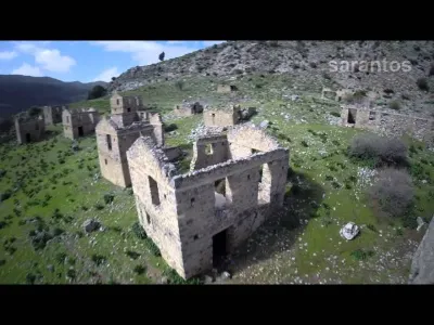
On the southern slopes of Psiloritis between the villages of Zaros and Vorizia is the village "ghost." Has abandoned for decades, settlement, which seems to have stopped the time clock at a certain date. The architecture, the symmetry of the buildings, the homogeneity, mass abandonment of the sealed doors and windows with stones, suggest that this place has a story to tell us ... Here we go back 72 years when the area was the lairs of the resistance group Petrakogiorgi and fighting for our freedom from the German occupying forces. It was August 15, 1943 (the day of Our Lady), when the team gave him a bloody battle in the nearby area of the Trahili. The Germans had big losses with rage and cruelty, a few days later, on August 26 went to the village Vorizia. They killed and executed many residents while airplanes threw bombs and destroyed everything. Then drove those left alive. After the liberation, the reconstruction ministry built a few hundred meters from the burnt Vorizia, the village "ghost" to relocate the residents there and named it New Vorizia. The village has never been inhabited and the proud Cretans rebuilt the Vorizia on the ashes of flattened their village. New Vorizia even stay there like a ghost village, to remind us that freedom, independence and pride, not donated, but be fought for !!
Map and restricted areas
Open in the main mapAviation weather (METAR and TAF)
LGIR – Heraklion International Nikos Kazantzakis Airport VFR
METAR
METAR LGIR 210720Z 28012KT 9999 FEW020 21/16 Q1018 NOSIG
- Wind
- 280°, 22 km/h
- Visibility
- 10 km or more
- Clouds
- Few (1-2/8) at 2,000 ft (610 m)
- Temperature
- 21 °C, dew point 16 °C
- QNH
- 1018 hPa
- Flight category
- VFR: ceiling > 3,000 ft and visibility > 5 mi
TAF
TAF LGIR 210500Z 2106/2206 29015KT 9999 FEW020 TEMPO 2106/2121 29015G25KT
| Period (local time) | Change | Wind | Visibility | Weather | Clouds |
|---|---|---|---|---|---|
| 21/11 08:00 → 22/11 08:00 | Initial conditions | 290°, 28 km/h | 10 km or more | Few (1-2/8) at 2,000 ft (610 m) | |
| 21/11 08:00 → 21/11 23:00 | Temporarily | 290°, 28 km/h, gusts 46 km/h |
Weather and Kp index
Sunrise and sunset
| Day | Dawn | Sunrise | Golden hour | Sunset | Dusk | Day length |
|---|---|---|---|---|---|---|
| Sat 21 Nov | 06:34 | 07:01 | 07:01–07:39 · 16:34–17:12 | 17:12 | 17:39 | 10 h 10 |
| Sun 22 Nov | 06:35 | 07:02 | 07:02–07:40 · 16:34–17:11 | 17:11 | 17:38 | 10 h 09 |
| Mon 23 Nov | 06:36 | 07:03 | 07:03–07:41 · 16:33–17:11 | 17:11 | 17:38 | 10 h 07 |
| Tue 24 Nov | 06:37 | 07:04 | 07:04–07:42 · 16:33–17:10 | 17:10 | 17:38 | 10 h 06 |
| Wed 25 Nov | 06:37 | 07:05 | 07:05–07:43 · 16:32–17:10 | 17:10 | 17:37 | 10 h 05 |
| Thu 26 Nov | 06:38 | 07:06 | 07:06–07:44 · 16:32–17:10 | 17:10 | 17:37 | 10 h 03 |
| Fri 27 Nov | 06:39 | 07:07 | 07:07–07:45 · 16:31–17:10 | 17:10 | 17:37 | 10 h 02 |
Reviews
Log in to review this spot. Log in · Create a free account
No reviews yet. Share yours!