

Utah Beach

No reviews yet
Have you flown here? Share your experience with other pilots.
+ Write the first reviewDescription
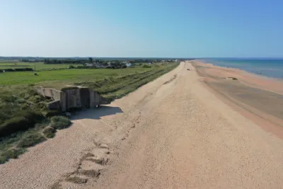
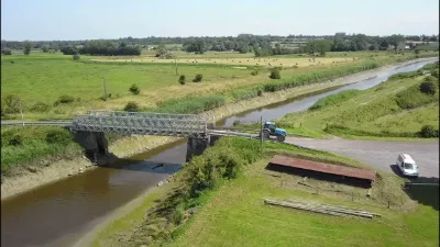
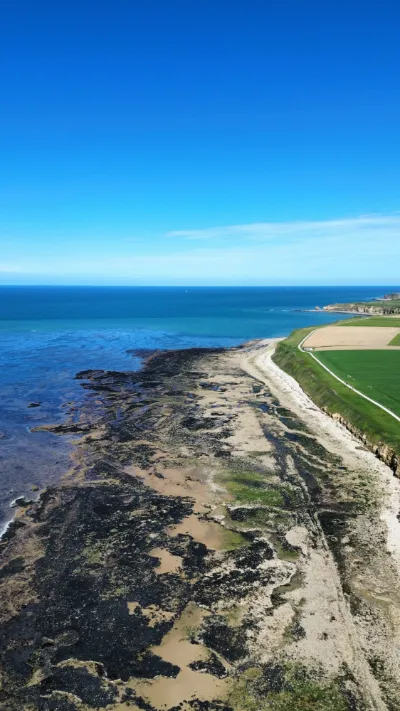
Utah Beach is the name of one of the five beaches of the Normandy landings on June 6, 1944. Utah Beach is the westernmost of the Allied Landing Zones and the only one located in the department of Manche on the northeast coast of the Cotentin, west of the Vire estuary (the other four are on the Calvados coast). Utah Beach extends from Sainte-Marie-du-Mont to Quinéville over a length of about 5km, with a main assault zone near Varreville. It was added to the initial landing plans, due to a greater number of landing barges finally available and thus allowed a bridgehead closer to the port of Cherbourg. The DB, commanded by General Leclerc, landed there on 30 July 1944. The landing at Utah Beach was certainly the least costly in terms of human lives and the one with the results, at the end of the first day, closest to the Allies' initial objectives. The American infantry division encountered relatively little enemy resistance there, in contrast to Omaha Beach, the other beach in the American sector. The German fortifications were smaller due to a configuration of the sites considered by the Germans as not very suitable for a landing. The beach is located on a barrier beach backed by marshy areas. The American landing on Utah will therefore be preceded by a night airborne operation, costly in human lives, on Sainte-Mère-Église and Chef-du-Pont in order to control the few roads through the marshes allowing beach exits.
Map and restricted areas
Open in the main mapNearby aerodromes
Open aerodromes within 25 km of the spot, heliports included, with their distance and direction from the spot. Near an aerodrome, drone flying is prohibited or height-limited: check the UAS zones map.
No known open aerodrome within 25 km.
Aviation weather (METAR and TAF)
LFRC – Cherbourg-Maupertus Airport LIFR
METAR
METAR LFRC 211100Z AUTO 16009KT 0300 R28/0375N FG VV/// 09/09 Q1016 BECMG 6000 NSW BKN002
- Wind
- 160°, 17 km/h
- Visibility
- 300 m
- Weather
- Fog
- Clouds
- –
- Temperature
- 9 °C, dew point 9 °C
- QNH
- 1016 hPa
- Flight category
- LIFR: ceiling < 500 ft or visibility < 1 mi
TAF
TAF LFRC 211100Z 2112/2121 17010KT 0300 FG VV/// BECMG 2112/2114 6000 NSW BKN003 BECMG 2114/2116 BKN008 TEMPO 2116/2120 BKN011 BECMG 2119/2121 13015G25KT
| Period (local time) | Change | Wind | Visibility | Weather | Clouds |
|---|---|---|---|---|---|
| 21/11 13:00 → 21/11 22:00 | Initial conditions | 170°, 19 km/h | 300 m | Fog | |
| 21/11 13:00 → 21/11 15:00 | Becoming | 170°, 19 km/h | 6 km | No significant weather | Broken (5-7/8) at 300 ft (90 m) |
| 21/11 15:00 → 21/11 20:00 | Becoming | 170°, 19 km/h | 6 km | No significant weather | Broken (5-7/8) at 800 ft (240 m) |
| 21/11 17:00 → 21/11 21:00 | Temporarily | Broken (5-7/8) at 1,100 ft (340 m) | |||
| 21/11 20:00 → 21/11 22:00 | Becoming | 130°, 28 km/h, gusts 46 km/h | 6 km | No significant weather | Broken (5-7/8) at 800 ft (240 m) |
Weather and Kp index
Sunrise and sunset
| Day | Dawn | Sunrise | Golden hour | Sunset | Dusk | Day length |
|---|---|---|---|---|---|---|
| Sat 21 Nov | 07:49 | 08:25 | 08:25–09:17 · 16:24–17:16 | 17:16 | 17:52 | 8 h 51 |
| Sun 22 Nov | 07:51 | 08:26 | 08:26–09:18 · 16:23–17:15 | 17:15 | 17:51 | 8 h 48 |
| Mon 23 Nov | 07:52 | 08:28 | 08:28–09:20 · 16:22–17:14 | 17:14 | 17:50 | 8 h 46 |
| Tue 24 Nov | 07:53 | 08:29 | 08:29–09:22 · 16:21–17:13 | 17:13 | 17:49 | 8 h 44 |
| Wed 25 Nov | 07:55 | 08:31 | 08:31–09:24 · 16:20–17:13 | 17:13 | 17:49 | 8 h 41 |
| Thu 26 Nov | 07:56 | 08:32 | 08:32–09:25 · 16:19–17:12 | 17:12 | 17:48 | 8 h 39 |
| Fri 27 Nov | 07:57 | 08:34 | 08:34–09:27 · 16:18–17:11 | 17:11 | 17:47 | 8 h 37 |



Reviews
Log in to review this spot. Log in · Create a free account
No reviews yet. Share yours!