

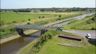
Carentan, the Haut Dick canal

No reviews yet
Have you flown here? Share your experience with other pilots.
+ Write the first reviewDescription
Linking the port of Carentan to the sea, it starts between the Douane and Russie districts in Carentan, then passes through the Haut Dick lock at the boundary between the communes of Saint-Côme-du-Mont and Saint-Hilaire-Petitville.
Here it receives the waters of the Douve and the Taute, and takes on a more natural form, like an ordinary river. It runs along the boundaries of Saint-Côme-du-Mont and Saint-Hilaire-Petitville, receives the waters of the Grand Fossé du Moulin at the boundary of Saint-Hilaire-Petitville and Brévands, and separates Brévands from Brucheville.
It ends at the English Channel in the baie des Veys, more precisely at the passe de Carentan, between the pointe de Brévands and the hamlet of Grand Vey in Brucheville.
On the Carentan canal bridge. It crosses the national road 13 via the Carentan canal bridge.
A walk well known to the people of Carentan runs along both sides of the canal. The Haut-Dick lock makes it possible to do a full loop, hence the local expression "faire le tour du Haut-Dick".
History Digging the canal was an idea of Napoleon I, who wanted a trans-Cotentin canal built between the baie des Veys and the west coast of the Cotentin to counter the British continental blockade.
Construction began in 1805 under the First Empire, but it was not until 1851 that the first and only section of this now obsolete project was put into service. The Haut-Dick canal did, however, allow Carentan to see its port activities flourish.
Map and restricted areas
Open in the main mapNearby aerodromes
Open aerodromes within 25 km of the spot, heliports included, with their distance and direction from the spot. Near an aerodrome, drone flying is prohibited or height-limited: check the UAS zones map.
| Aerodrome | Type | Distance | Elevation | Difference |
|---|---|---|---|---|
| Aérodrome de Lessay | Aerodrome | 24 km SW | 28 m | spot 26 m lower |
Aviation weather (METAR and TAF)
LFRC – Cherbourg-Maupertus Airport LIFR
METAR
METAR LFRC 211100Z AUTO 16009KT 0300 R28/0375N FG VV/// 09/09 Q1016 BECMG 6000 NSW BKN002
- Wind
- 160°, 17 km/h
- Visibility
- 300 m
- Weather
- Fog
- Clouds
- –
- Temperature
- 9 °C, dew point 9 °C
- QNH
- 1016 hPa
- Flight category
- LIFR: ceiling < 500 ft or visibility < 1 mi
TAF
TAF LFRC 211100Z 2112/2121 17010KT 0300 FG VV/// BECMG 2112/2114 6000 NSW BKN003 BECMG 2114/2116 BKN008 TEMPO 2116/2120 BKN011 BECMG 2119/2121 13015G25KT
| Period (local time) | Change | Wind | Visibility | Weather | Clouds |
|---|---|---|---|---|---|
| 21/11 13:00 → 21/11 22:00 | Initial conditions | 170°, 19 km/h | 300 m | Fog | |
| 21/11 13:00 → 21/11 15:00 | Becoming | 170°, 19 km/h | 6 km | No significant weather | Broken (5-7/8) at 300 ft (90 m) |
| 21/11 15:00 → 21/11 20:00 | Becoming | 170°, 19 km/h | 6 km | No significant weather | Broken (5-7/8) at 800 ft (240 m) |
| 21/11 17:00 → 21/11 21:00 | Temporarily | Broken (5-7/8) at 1,100 ft (340 m) | |||
| 21/11 20:00 → 21/11 22:00 | Becoming | 130°, 28 km/h, gusts 46 km/h | 6 km | No significant weather | Broken (5-7/8) at 800 ft (240 m) |
Weather and Kp index
| Day | Weather | Temp. min. / max. | Wind | Rain | Max Kp |
|---|---|---|---|---|---|
| Sat 21 Nov | Cloudy | 10° / 12° | 23 km/h SE | – | 2 |
| Sun 22 Nov | Heavy rain | 9° / 11° | 43 km/h W | 34 mm | 2 |
| Mon 23 Nov | Rain | 7° / 10° | 18 km/h E | 5.5 mm | 4 |
| Tue 24 Nov | Fair | 2° / 7° | 17 km/h S | – | 2 |
| Wed 25 Nov | Cloudy | 2° / 5° | 24 km/h E | – | – |
| Thu 26 Nov | Partly cloudy | -0° / 4° | 17 km/h E | – | – |
| Fri 27 Nov | Light rain | -2° / 9° | 25 km/h SE | 2.4 mm | – |
Hour by hour: Saturday 21 November
| Time | Weather | Temp. | Wind | Rain | Clouds | Kp |
|---|---|---|---|---|---|---|
| 12:00 | Cloudy | 10° | 13 km/h SE | – | 98 % | 2 |
| 13:00 | Cloudy | 11° | 14 km/h SE | – | 95 % | 1 |
| 14:00 | Partly cloudy | 12° | 15 km/h SE | – | 74 % | 1 |
| 15:00 | Fair | 12° | 15 km/h SE | – | 24 % | 1 |
| 16:00 | Fair | 12° | 15 km/h SE | – | 26 % | 2 |
| 17:00 | Fair | 10° | 17 km/h SE | – | 29 % | 2 |
| 18:00 | Partly cloudy | 10° | 19 km/h SE | – | 67 % | 2 |
| 19:00 | Cloudy | 10° | 19 km/h SE | – | 100 % | 2 |
| 20:00 | Cloudy | 10° | 20 km/h SE | – | 100 % | 2 |
| 21:00 | Cloudy | 10° | 21 km/h SE | – | 100 % | 2 |
| 22:00 | Cloudy | 10° | 23 km/h SE | – | 100 % | 2 |
Hour by hour: Sunday 22 November
| Time | Weather | Temp. | Wind | Rain | Clouds | Kp |
|---|---|---|---|---|---|---|
| 06:00 | Heavy rain | 10° | 26 km/h E | 2.7 mm | 100 % | 2 |
| 07:00 | Heavy rain | 10° | 25 km/h E | 2.1 mm | 100 % | 2 |
| 08:00 | Heavy rain | 9° | 25 km/h E | 2.1 mm | 100 % | 2 |
| 09:00 | Heavy rain | 9° | 24 km/h E | 1.9 mm | 100 % | 2 |
| 10:00 | Heavy rain | 9° | 23 km/h E | 2.5 mm | 100 % | 2 |
| 11:00 | Heavy rain | 10° | 22 km/h E | 2.6 mm | 100 % | 2 |
| 12:00 | Heavy rain | 9° | 21 km/h E | 1.4 mm | 100 % | 2 |
| 13:00 | Heavy rain | 10° | 20 km/h E | 1.9 mm | 100 % | 2 |
| 14:00 | Heavy rain | 10° | 24 km/h SW | 1.7 mm | 100 % | 2 |
| 15:00 | Heavy rain | 11° | 27 km/h W | 1.2 mm | 100 % | 2 |
| 16:00 | Light rain | 11° | 36 km/h W | 0.4 mm | 100 % | 2 |
| 17:00 | Light rain | 11° | 40 km/h W | 0.3 mm | 100 % | 2 |
| 18:00 | Light rain | 11° | 40 km/h W | 0.2 mm | 100 % | 2 |
| 19:00 | Rain | 11° | 43 km/h W | 0.7 mm | 100 % | 2 |
| 20:00 | Rain | 10° | 38 km/h W | 0.8 mm | 100 % | 2 |
| 21:00 | Rain | 10° | 31 km/h N | 0.9 mm | 100 % | 2 |
| 22:00 | Rain | 10° | 28 km/h N | 0.6 mm | 100 % | 2 |
Sunrise and sunset
| Day | Dawn | Sunrise | Golden hour | Sunset | Dusk | Day length |
|---|---|---|---|---|---|---|
| Sat 21 Nov | 07:49 | 08:25 | 08:25–09:16 · 16:25–17:17 | 17:17 | 17:52 | 8 h 52 |
| Sun 22 Nov | 07:51 | 08:26 | 08:26–09:18 · 16:24–17:16 | 17:16 | 17:51 | 8 h 49 |
| Mon 23 Nov | 07:52 | 08:28 | 08:28–09:20 · 16:23–17:15 | 17:15 | 17:51 | 8 h 47 |
| Tue 24 Nov | 07:53 | 08:29 | 08:29–09:22 · 16:22–17:14 | 17:14 | 17:50 | 8 h 44 |
| Wed 25 Nov | 07:55 | 08:31 | 08:31–09:23 · 16:21–17:13 | 17:13 | 17:49 | 8 h 42 |
| Thu 26 Nov | 07:56 | 08:32 | 08:32–09:25 · 16:19–17:12 | 17:12 | 17:48 | 8 h 40 |
| Fri 27 Nov | 07:57 | 08:33 | 08:33–09:27 · 16:18–17:12 | 17:12 | 17:48 | 8 h 38 |





Reviews
Log in to review this spot. Log in · Create a free account
No reviews yet. Share yours!