Skip to content
Mountain

Col du Nufenen
Switzerland

The video is only loaded from YouTube (youtube-nocookie.com) when you start it.

No reviews yet

Have you flown here? Share your experience with other pilots.

+ Write the first review

Description

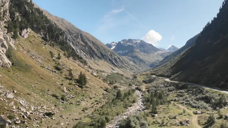
This pass unites the cantons of Valais and Ticino. The images were taken on the Valaisan side of the pass.

Aviation weather (METAR and TAF)

LSMM – Meiringen Airport · 36 km NW ?

METAR

Observed 21/11 07:50 · 29 min ago

METAR LSMM 210650Z AUTO 09008KT 9999NDV -SHRA SCT013 BKN025 OVC056 04/03 Q1020 RMK

Wind
090°, 15 km/h
Visibility
–
Weather
Showers of rain light
Clouds
Scattered (3-4/8) at 1,300 ft (400 m) ; Broken (5-7/8) at 2,500 ft (760 m) ; Overcast (8/8) at 5,600 ft (1710 m)
Temperature
4 °C, dew point 3 °C
QNH
1020 hPa
Flight category
Unknown category

TAF

This station does not issue a TAF (or none is currently valid).

METAR and TAF from NOAA (Aviation Weather Center), for guidance only: they do not replace flight planning with official sources (SIA, Météo-France). Nearest station that issues a METAR, not necessarily the nearest aerodrome.

Plan the light

Weather and Kp index

Loading forecast…

Sunrise and sunset

Local times at the spot (UTC+01:00). The golden hour, the warm, low light sought after for photos and videos, runs from sunrise until the sun reaches 6° above the horizon, and in the evening from 6° until sunset.

Day Dawn Sunrise Golden hour Sunset Dusk Day length
Sat 21 Nov07:03 07:37 07:37–08:24 · 16:00–16:48 16:48 17:219 h 11
Sun 22 Nov07:05 07:38 07:38–08:26 · 15:59–16:47 16:47 17:209 h 09
Mon 23 Nov07:06 07:39 07:39–08:27 · 15:58–16:46 16:46 17:209 h 07
Tue 24 Nov07:07 07:41 07:41–08:29 · 15:57–16:46 16:46 17:199 h 04
Wed 25 Nov07:08 07:42 07:42–08:30 · 15:57–16:45 16:45 17:189 h 02
Thu 26 Nov07:10 07:43 07:43–08:32 · 15:56–16:44 16:44 17:189 h 00
Fri 27 Nov07:11 07:45 07:45–08:33 · 15:55–16:44 16:44 17:178 h 59

Nearby on Wikipedia

  • Col du Nufenen · 0.4 km away

    Le col du Nufenen (en allemand Nufenenpass, en italien Novena) est un col des Alpes suisses. La route va d’Ulrichen, dans le canton du Valais, à Airolo, dans le canton du Tessin. Elle est longue de 38 kilomètres (...)

  • Barrage de Gries · 2.2 km away

    Le barrage de Gries est un barrage hydroélectrique situé en Suisse dans le canton du Valais. (...)

  • Klein Grieshorn · 3.0 km away

    Le Klein Grieshorn ou Piccolo Corno Gries est un sommet des Alpes situé à la frontière entre l'Italie et la Suisse, culminant à d'altitude. (...)

  • Col de Gries · 3.2 km away

    Le col de Gries est un col alpin, culminant à , accessible par un sentier. Il est situé sur la crête principale des Alpes du sud, sur la frontière entre l'Italie et la Suisse. Ce n'est pas un col routier. (...)

  • Col de San Giacomo · 5.8 km away

    Le col de San Giacomo est un col de montagne situé dans les Alpes, à la frontière entre l'Italie et la Suisse, culminant à d'altitude. (...)

Articles found by GeoNames from the spot's position.

Nearby spots

Reviews

Log in to review this spot. Log in · Create a free account

No reviews yet. Share yours!

Connection to the site lost. Trying again…

The site is not responding. Trying again in seconds.

The site is no longer responding.

The site has been updated. Reloading the page…

This page has expired.

Resuming failed. Please reload the page.

The site is no longer responding.