

Bouin
1 pilot review
“Super spot, j'y étais il y a quelques jours avec mon Mavic Mini mais malheureusement le ve…” — antoinedrone94, 4 years ago
Read the reviews + Write my reviewDescription
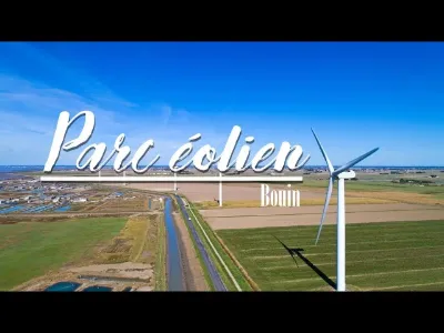
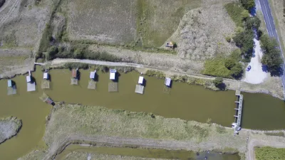
FINALLY!!! After several months of pause (including 2 months due to the confinement) the Mi drone went to stretch the propellers. Today a short flight over the wind farm of Bouin (85), located on the seafront facing the bay of Bourgneuf - en Retz (44). The weather was nice with a few clouds, the wind was very present, ideal to dust off this good old Mi drone 4K. The wind farm consists of 8 wind turbines. Moved by three 40m long blades, the wind turbines with a power of 2.4 and 2.5 MW and whose total power reaches 19.5 MW produce about 40 million KWh, which corresponds to the electricity consumption of 20,000 households, excluding heating. The presence of these wind turbines in the municipality of Bouin is not anachronistic since, in the past, the municipality had up to 14 mills on its territory. You can reach them by road by following the direction of Beauvoir-sur-Mer and then the port of Le Bec (see previous video). A bicycle path runs along the windmill line so that you can enjoy the good sea air nearby.
Map and restricted areas
Open in the main mapNearby aerodromes
Open aerodromes within 25 km of the spot, heliports included, with their distance and direction from the spot. Near an aerodrome, drone flying is prohibited or height-limited: check the UAS zones map.
| Aerodrome | Type | Distance | Elevation | Difference |
|---|---|---|---|---|
| Beauvoir Fromentine Airport | Aerodrome | 8.1 km SW | 3 m | same altitude as the spot |
| Beauvoir-Sur-Mer Fromentine Heliport | Heliport | 8.1 km SW | 3 m | same altitude as the spot |
| Challans Heliport | Heliport | 20 km SE | 40 m | spot 38 m lower |
| Piste privée de La Cornélie | Aerodrome | 24 km SE | 61 m | spot 59 m lower |
Aviation weather (METAR and TAF)
LFRS – Nantes Atlantique Airport LIFR
METAR
METAR LFRS 211030Z AUTO 12009KT 060V150 0750 0650 R03/0900U R21/1400U FG VV/// 11/11 Q1016 BECMG 9999 NSW BKN014
- Wind
- 120°, 17 km/h
- Visibility
- 750 m
- Weather
- Fog
- Clouds
- –
- Temperature
- 11 °C, dew point 11 °C
- QNH
- 1016 hPa
- Flight category
- LIFR: ceiling < 500 ft or visibility < 1 mi
TAF
TAF AMD LFRS 211004Z 2110/2212 VRB03KT 2500 BR OVC002 TEMPO 2110/2111 0300 FG VV/// BECMG 2110/2112 13010KT 9999 NSW BKN003 BECMG 2112/2114 BKN014 BECMG 2114/2116 SCT016 BECMG 2118/2121 4500 -RA BKN014 TEMPO 2121/2202 2500 DZRA BKN006 OVC015 TEMPO 2202/2205 2500 RA BKN012 SCT025CB FM220500 25012KT 9999 SCT012 TEMPO 2205/2212 26020G35KT 3000 SHRA BKN020CB
| Period (local time) | Change | Wind | Visibility | Weather | Clouds |
|---|---|---|---|---|---|
| 21/11 11:00 → 22/11 13:00 | Initial conditions | Variable, 6 km/h | 2.5 km | Mist | Overcast (8/8) at 200 ft (60 m) |
| 21/11 11:00 → 21/11 12:00 | Temporarily | 300 m | Fog | ||
| 21/11 11:00 → 21/11 13:00 | Becoming | 130°, 19 km/h | 10 km or more | No significant weather | Broken (5-7/8) at 300 ft (90 m) |
| 21/11 13:00 → 21/11 15:00 | Becoming | 130°, 19 km/h | 10 km or more | No significant weather | Broken (5-7/8) at 1,400 ft (430 m) |
| 21/11 15:00 → 21/11 19:00 | Becoming | 130°, 19 km/h | 10 km or more | No significant weather | Scattered (3-4/8) at 1,600 ft (490 m) |
| 21/11 19:00 → 22/11 06:00 | Becoming | 130°, 19 km/h | 4.5 km | Rain light | Broken (5-7/8) at 1,400 ft (430 m) |
| 21/11 22:00 → 22/11 03:00 | Temporarily | 2.5 km | Drizzle ; rain | Broken (5-7/8) at 600 ft (180 m) ; Overcast (8/8) at 1,500 ft (460 m) | |
| 22/11 03:00 → 22/11 06:00 | Temporarily | 2.5 km | Rain | Broken (5-7/8) at 1,200 ft (370 m) ; Scattered (3-4/8) at 2,500 ft (760 m) (cumulonimbus) | |
| 22/11 06:00 → 22/11 13:00 | From | 250°, 22 km/h | 10 km or more | Scattered (3-4/8) at 1,200 ft (370 m) | |
| 22/11 06:00 → 22/11 13:00 | Temporarily | 260°, 37 km/h, gusts 65 km/h | 3.0 km | Showers of rain | Broken (5-7/8) at 2,000 ft (610 m) (cumulonimbus) |
Weather and Kp index
Sunrise and sunset
| Day | Dawn | Sunrise | Golden hour | Sunset | Dusk | Day length |
|---|---|---|---|---|---|---|
| Sat 21 Nov | 07:46 | 08:20 | 08:20–09:08 · 16:40–17:28 | 17:28 | 18:02 | 9 h 08 |
| Sun 22 Nov | 07:48 | 08:21 | 08:21–09:10 · 16:39–17:27 | 17:27 | 18:01 | 9 h 06 |
| Mon 23 Nov | 07:49 | 08:23 | 08:23–09:11 · 16:38–17:26 | 17:26 | 18:00 | 9 h 03 |
| Tue 24 Nov | 07:50 | 08:24 | 08:24–09:13 · 16:37–17:26 | 17:26 | 18:00 | 9 h 01 |
| Wed 25 Nov | 07:51 | 08:25 | 08:25–09:14 · 16:36–17:25 | 17:25 | 17:59 | 8 h 59 |
| Thu 26 Nov | 07:53 | 08:27 | 08:27–09:16 · 16:35–17:24 | 17:24 | 17:58 | 8 h 57 |
| Fri 27 Nov | 07:54 | 08:28 | 08:28–09:17 · 16:34–17:24 | 17:24 | 17:58 | 8 h 55 |


Reviews
Log in to review this spot. Log in · Create a free account
antoinedrone94
Super spot, j'y étais il y a quelques jours avec mon Mavic Mini mais malheureusement le vent était de la partie. Merci pour le partage.👍