

Chapel Saint-Michel de Prunières (From 0 to 30 sec.)

No reviews yet
Have you flown here? Share your experience with other pilots.
+ Write the first reviewDescription
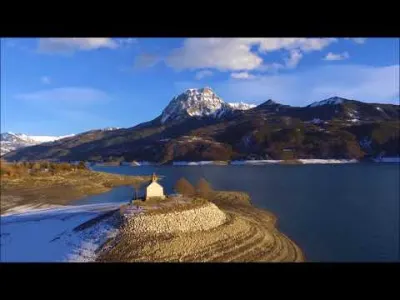
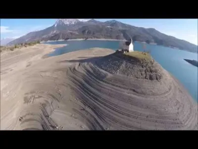
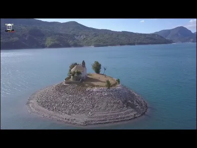
Around the year 1020, the Abbey of Notre-Dame de Boscodon had a priory which dominated the Durance valley on its right bank, between Chorges and Prunières1. The chapel, built in the eleventh century on a small eminence, in the hamlet of Les Couches2, associated with the abbey of Saint-Michel-de-la-Cluse3, was destroyed in 1692 by the troops of the Duke of Savoy Victor-Amédée II. Rebuilt in the 17th century, it became a place of pilgrimage for the parishioners of Chorges and Prunières, who used to go there in crowds on 29 September, the feast of Saint Michael.
When the dam was built in 1961, the destruction of the chapel was planned, but as it was at an altitude slightly higher than the theoretical maximum elevation of the future lake, it was finally saved. The chapel now stands alone on an islet a few tens of square metres above the lake level. The cemetery has been engulfed, and the chapel walled up. One can still approach it during low water, but not enter it. Religious services are sometimes celebrated on boats near the chapel.
Map and restricted areas
Open in the main mapNearby aerodromes
Open aerodromes within 25 km of the spot, heliports included, with their distance and direction from the spot. Near an aerodrome, drone flying is prohibited or height-limited: check the UAS zones map.
| Aerodrome | Type | Distance | Elevation | Difference |
|---|---|---|---|---|
| Seyne les Alpes Glider Field | Aerodrome | 20 km S | 1,200 m | spot 418 m lower |
| Hôpital Heliport | Heliport | 21 km W | 759 m | spot 23 m higher |
| Gap - Tallard Airfield | Aerodrome | 25 km W | 605 m | spot 177 m higher |
Aviation weather (METAR and TAF)
No METAR station within 50 km.
Weather and Kp index
| Day | Weather | Temp. min. / max. | Wind | Rain | Max Kp |
|---|---|---|---|---|---|
| Sat 21 Nov | Fair | 5° / 13° | 6 km/h SW | – | 2 |
| Sun 22 Nov | Showers | 4° / 9° | 16 km/h W | 30 mm | 2 |
| Mon 23 Nov | Cloudy | 1° / 7° | 12 km/h SW | – | 4 |
| Tue 24 Nov | Cloudy | 1° / 11° | 8 km/h E | 0.3 mm | 2 |
| Wed 25 Nov | Heavy rain | 3° / 6° | 16 km/h E | 26 mm | – |
| Thu 26 Nov | Clear sky | 1° / 7° | 4 km/h E | 1.0 mm | – |
| Fri 27 Nov | Partly cloudy | -4° / 8° | 7 km/h E | – | – |
Hour by hour: Saturday 21 November
| Time | Weather | Temp. | Wind | Rain | Clouds | Kp |
|---|---|---|---|---|---|---|
| 10:00 | Partly cloudy | 7° | 6 km/h SE | – | 68 % | 2 |
| 11:00 | Partly cloudy | 9° | 6 km/h SE | – | 75 % | 2 |
| 12:00 | Fair | 11° | 5 km/h S | – | 32 % | 2 |
| 13:00 | Fair | 12° | 5 km/h SW | – | 30 % | 1 |
| 14:00 | Clear sky | 13° | 6 km/h SW | – | 11 % | 1 |
| 15:00 | Partly cloudy | 12° | 6 km/h SW | – | 42 % | 1 |
| 16:00 | Partly cloudy | 11° | 5 km/h S | – | 68 % | 2 |
| 17:00 | Partly cloudy | 9° | 2 km/h E | – | 84 % | 2 |
| 18:00 | Cloudy | 8° | 3 km/h E | – | 90 % | 2 |
| 19:00 | Partly cloudy | 7° | 4 km/h E | – | 77 % | 2 |
| 20:00 | Partly cloudy | 6° | 4 km/h E | – | 87 % | 2 |
| 21:00 | Cloudy | 5° | 6 km/h E | – | 94 % | 2 |
| 22:00 | Cloudy | 5° | 6 km/h E | – | 100 % | 2 |
Hour by hour: Sunday 22 November
| Time | Weather | Temp. | Wind | Rain | Clouds | Kp |
|---|---|---|---|---|---|---|
| 06:00 | Heavy rain | 7° | 8 km/h E | 1.5 mm | 100 % | 2 |
| 07:00 | Heavy rain | 7° | 8 km/h NE | 2.7 mm | 100 % | 2 |
| 08:00 | Heavy rain | 8° | 8 km/h NE | 4.0 mm | 100 % | 2 |
| 09:00 | Heavy rain | 8° | 5 km/h NE | 3.3 mm | 100 % | 2 |
| 10:00 | Heavy rain | 8° | 6 km/h NE | 2.1 mm | 100 % | 2 |
| 11:00 | Rain | 8° | 16 km/h W | 0.5 mm | 99 % | 2 |
| 12:00 | Heavy rain | 9° | 16 km/h SW | 1.6 mm | 100 % | 2 |
| 13:00 | Showers | 8° | 15 km/h W | 1.7 mm | 74 % | 2 |
| 14:00 | Showers | 8° | 12 km/h W | 0.7 mm | 73 % | 2 |
| 15:00 | Showers | 8° | 13 km/h W | 0.9 mm | 57 % | 2 |
| 16:00 | Showers | 7° | 12 km/h W | 0.6 mm | 68 % | 2 |
| 17:00 | Showers | 7° | 13 km/h W | 0.4 mm | 58 % | 2 |
| 18:00 | Showers | 6° | 11 km/h W | 0.1 mm | 64 % | 2 |
| 19:00 | Showers | 6° | 10 km/h SW | 0.4 mm | 71 % | 2 |
| 20:00 | Showers | 5° | 8 km/h SW | 0.3 mm | 77 % | 2 |
| 21:00 | Showers | 5° | 8 km/h SW | 0.3 mm | 73 % | 2 |
| 22:00 | Heavy rain | 4° | 7 km/h S | 1.2 mm | 98 % | 2 |
Sunrise and sunset
| Day | Dawn | Sunrise | Golden hour | Sunset | Dusk | Day length |
|---|---|---|---|---|---|---|
| Sat 21 Nov | 07:07 | 07:39 | 07:39–08:24 · 16:17–17:02 | 17:02 | 17:34 | 9 h 23 |
| Sun 22 Nov | 07:08 | 07:40 | 07:40–08:25 · 16:16–17:01 | 17:01 | 17:33 | 9 h 21 |
| Mon 23 Nov | 07:09 | 07:41 | 07:41–08:27 · 16:15–17:01 | 17:01 | 17:33 | 9 h 19 |
| Tue 24 Nov | 07:11 | 07:43 | 07:43–08:28 · 16:14–17:00 | 17:00 | 17:32 | 9 h 17 |
| Wed 25 Nov | 07:12 | 07:44 | 07:44–08:30 · 16:14–16:59 | 16:59 | 17:32 | 9 h 15 |
| Thu 26 Nov | 07:13 | 07:45 | 07:45–08:31 · 16:13–16:59 | 16:59 | 17:31 | 9 h 13 |
| Fri 27 Nov | 07:14 | 07:46 | 07:46–08:32 · 16:12–16:58 | 16:58 | 17:31 | 9 h 11 |


Reviews
Log in to review this spot. Log in · Create a free account
No reviews yet. Share yours!