

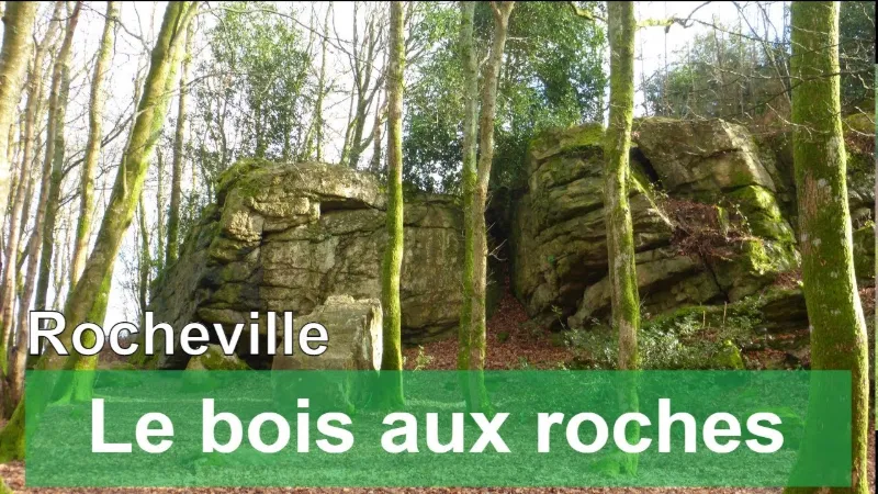
Rocheville, the wood of rocks
No reviews yet
Have you flown here? Share your experience with other pilots.
+ Write the first reviewDescription
Rocheville is a rural commune, as it is one of the sparsely or very sparsely populated communes, according to the Insee commune density grid.
The commune is also part of the catchment area of Cherbourg-en-Cotentin, of which it is a commune of the outer ring. This area, which includes 77 communes, is categorized among the areas with 50,000 to fewer than 200,000 inhabitants.
The colline des Grosses Roches is a site of chaotic sandstone formations, classified as a natural site. It holds at least three covered alleys known as such since the early 18th century. On this hill, a bronze mold for "wedges" (the name given to bronze axes) was discovered at that time in perfect condition, along with a "waxy" flint axe 25 cm long, now in the Cherbourg museum.
Video
Map and restricted areas
Open in the main mapNearby aerodromes
Open aerodromes within 25 km of the spot, heliports included, with their distance and direction from the spot. Near an aerodrome, drone flying is prohibited or height-limited: check the UAS zones map.
| Aerodrome | Type | Distance | Elevation | Difference |
|---|---|---|---|---|
| Centre Hospitalier Heliport | Heliport | 16 km N | 19 m | spot 17 m higher |
| Arsenal-Premar Heliport | Heliport | 18 km N | 8 m | spot 28 m higher |
| Cherbourg-Maupertus Airport | Airport | 18 km NE | 140 m | spot 104 m lower |
| Flamanville Heliport | Heliport | 22 km W | 82 m | spot 46 m lower |
| Aérodrome de Vauville | Aerodrome | 23 km NW | 139 m | spot 103 m lower |
Aviation weather (METAR and TAF)
LFRC – Cherbourg-Maupertus Airport LIFR
METAR
METAR LFRC 211130Z AUTO 15009KT 0350 0300 R28/0400N FG VV/// 09/09 Q1016 BECMG 6000 NSW BKN003
- Wind
- 150°, 17 km/h
- Visibility
- 350 m
- Weather
- Fog
- Clouds
- –
- Temperature
- 9 °C, dew point 9 °C
- QNH
- 1016 hPa
- Flight category
- LIFR: ceiling < 500 ft or visibility < 1 mi
TAF
TAF LFRC 211100Z 2112/2121 17010KT 0300 FG VV/// BECMG 2112/2114 6000 NSW BKN003 BECMG 2114/2116 BKN008 TEMPO 2116/2120 BKN011 BECMG 2119/2121 13015G25KT
| Period (local time) | Change | Wind | Visibility | Weather | Clouds |
|---|---|---|---|---|---|
| 21/11 13:00 → 21/11 22:00 | Initial conditions | 170°, 19 km/h | 300 m | Fog | |
| 21/11 13:00 → 21/11 15:00 | Becoming | 170°, 19 km/h | 6 km | No significant weather | Broken (5-7/8) at 300 ft (90 m) |
| 21/11 15:00 → 21/11 20:00 | Becoming | 170°, 19 km/h | 6 km | No significant weather | Broken (5-7/8) at 800 ft (240 m) |
| 21/11 17:00 → 21/11 21:00 | Temporarily | Broken (5-7/8) at 1,100 ft (340 m) | |||
| 21/11 20:00 → 21/11 22:00 | Becoming | 130°, 28 km/h, gusts 46 km/h | 6 km | No significant weather | Broken (5-7/8) at 800 ft (240 m) |
Weather and Kp index
Sunrise and sunset
| Day | Dawn | Sunrise | Golden hour | Sunset | Dusk | Day length |
|---|---|---|---|---|---|---|
| Sat 21 Nov | 07:51 | 08:27 | 08:27–09:19 · 16:26–17:18 | 17:18 | 17:53 | 8 h 50 |
| Sun 22 Nov | 07:52 | 08:28 | 08:28–09:20 · 16:24–17:17 | 17:17 | 17:52 | 8 h 48 |
| Mon 23 Nov | 07:54 | 08:30 | 08:30–09:22 · 16:23–17:16 | 17:16 | 17:52 | 8 h 45 |
| Tue 24 Nov | 07:55 | 08:31 | 08:31–09:24 · 16:22–17:15 | 17:15 | 17:51 | 8 h 43 |
| Wed 25 Nov | 07:57 | 08:33 | 08:33–09:26 · 16:21–17:14 | 17:14 | 17:50 | 8 h 41 |
| Thu 26 Nov | 07:58 | 08:34 | 08:34–09:27 · 16:20–17:13 | 17:13 | 17:49 | 8 h 38 |
| Fri 27 Nov | 07:59 | 08:36 | 08:36–09:29 · 16:19–17:12 | 17:12 | 17:49 | 8 h 36 |




Reviews
Log in to review this spot. Log in · Create a free account
No reviews yet. Share yours!