

Fresville quarry geosite
No reviews yet
Have you flown here? Share your experience with other pilots.
+ Write the first reviewDescription
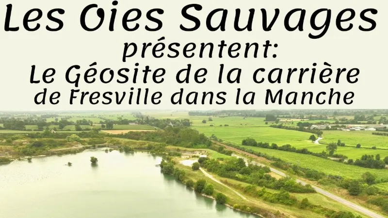
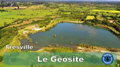
Signposted from the village of Fresville. Laid out around the lake of a former industrial cement production site, this trail lets you discover the geological history of Normandy and the changing landscapes of the site: from marine fossils to limestone extraction, from tectonic deformations to diving birds. 2 km – 2h The Fresville quarry geosite is a real window onto the geological history of Normandy and the evolution of the Cotentin landscapes. Located near the village of Fresville, this trail laid out around the lake of a former industrial quarry invites young and old to a fascinating immersion in the heart of regional geology.
The 2 km route, dotted with information panels, takes you back in time several million years. The industrial history of the site is also highlighted: the Fresville quarry was worked for cement production, an activity that deeply marked the local landscape. Today, nature has taken back its rights around the lake, providing a refuge for a variety of wildlife,
The Fresville quarry geosite is a unique place to combine a nature walk, scientific discovery and wildlife watching. It's an ideal destination for a family outing, an educational hike or a contemplative break by the water, in a place where the memory of the Earth is laid out in the open air.
Map and restricted areas
Open in the main mapNearby aerodromes
Open aerodromes within 25 km of the spot, heliports included, with their distance and direction from the spot. Near an aerodrome, drone flying is prohibited or height-limited: check the UAS zones map.
| Aerodrome | Type | Distance | Elevation | Difference |
|---|---|---|---|---|
| Cherbourg-Maupertus Airport | Airport | 24 km N | 140 m | spot 125 m lower |
Aviation weather (METAR and TAF)
LFRC – Cherbourg-Maupertus Airport LIFR
METAR
METAR LFRC 211130Z AUTO 15009KT 0350 0300 R28/0400N FG VV/// 09/09 Q1016 BECMG 6000 NSW BKN003
- Wind
- 150°, 17 km/h
- Visibility
- 350 m
- Weather
- Fog
- Clouds
- –
- Temperature
- 9 °C, dew point 9 °C
- QNH
- 1016 hPa
- Flight category
- LIFR: ceiling < 500 ft or visibility < 1 mi
TAF
TAF LFRC 211100Z 2112/2121 17010KT 0300 FG VV/// BECMG 2112/2114 6000 NSW BKN003 BECMG 2114/2116 BKN008 TEMPO 2116/2120 BKN011 BECMG 2119/2121 13015G25KT
| Period (local time) | Change | Wind | Visibility | Weather | Clouds |
|---|---|---|---|---|---|
| 21/11 13:00 → 21/11 22:00 | Initial conditions | 170°, 19 km/h | 300 m | Fog | |
| 21/11 13:00 → 21/11 15:00 | Becoming | 170°, 19 km/h | 6 km | No significant weather | Broken (5-7/8) at 300 ft (90 m) |
| 21/11 15:00 → 21/11 20:00 | Becoming | 170°, 19 km/h | 6 km | No significant weather | Broken (5-7/8) at 800 ft (240 m) |
| 21/11 17:00 → 21/11 21:00 | Temporarily | Broken (5-7/8) at 1,100 ft (340 m) | |||
| 21/11 20:00 → 21/11 22:00 | Becoming | 130°, 28 km/h, gusts 46 km/h | 6 km | No significant weather | Broken (5-7/8) at 800 ft (240 m) |
Weather and Kp index
| Day | Weather | Temp. min. / max. | Wind | Rain | Max Kp |
|---|---|---|---|---|---|
| Sat 21 Nov | Fog | 9° / 12° | 23 km/h E | 0.4 mm | 2 |
| Sun 22 Nov | Heavy rain | 9° / 11° | 45 km/h W | 35 mm | 2 |
| Mon 23 Nov | Rain | 7° / 10° | 19 km/h E | 5.5 mm | 4 |
| Tue 24 Nov | Clear sky | 5° / 9° | 21 km/h SE | 0.2 mm | 2 |
| Wed 25 Nov | Cloudy | 4° / 7° | 25 km/h E | 0.8 mm | – |
| Thu 26 Nov | Cloudy | 3° / 6° | 20 km/h E | – | – |
| Fri 27 Nov | Partly cloudy | -3° / 2° | 19 km/h E | – | – |
Hour by hour: Saturday 21 November
| Time | Weather | Temp. | Wind | Rain | Clouds | Kp |
|---|---|---|---|---|---|---|
| 12:00 | Fog | 9° | 12 km/h SE | – | 100 % | 2 |
| 13:00 | Fog | 10° | 13 km/h SE | – | 100 % | 1 |
| 14:00 | Cloudy | 11° | 16 km/h SE | – | 93 % | 1 |
| 15:00 | Partly cloudy | 12° | 15 km/h SE | – | 43 % | 1 |
| 16:00 | Fair | 12° | 15 km/h SE | – | 30 % | 2 |
| 17:00 | Fair | 10° | 18 km/h SE | – | 28 % | 2 |
| 18:00 | Partly cloudy | 9° | 19 km/h SE | – | 65 % | 2 |
| 19:00 | Cloudy | 9° | 21 km/h SE | – | 100 % | 2 |
| 20:00 | Cloudy | 10° | 22 km/h SE | – | 100 % | 2 |
| 21:00 | Cloudy | 10° | 22 km/h E | – | 100 % | 2 |
| 22:00 | Light rain | 10° | 23 km/h E | 0.1 mm | 100 % | 2 |
Hour by hour: Sunday 22 November
| Time | Weather | Temp. | Wind | Rain | Clouds | Kp |
|---|---|---|---|---|---|---|
| 06:00 | Heavy rain | 9° | 28 km/h E | 3.1 mm | 100 % | 2 |
| 07:00 | Heavy rain | 9° | 27 km/h E | 2.1 mm | 100 % | 2 |
| 08:00 | Heavy rain | 9° | 28 km/h E | 1.6 mm | 100 % | 2 |
| 09:00 | Heavy rain | 9° | 28 km/h E | 1.6 mm | 100 % | 2 |
| 10:00 | Heavy rain | 9° | 27 km/h E | 3.1 mm | 100 % | 2 |
| 11:00 | Heavy rain | 9° | 27 km/h E | 1.3 mm | 100 % | 2 |
| 12:00 | Heavy rain | 9° | 24 km/h E | 1.3 mm | 100 % | 2 |
| 13:00 | Heavy rain | 9° | 22 km/h E | 2.3 mm | 100 % | 2 |
| 14:00 | Heavy rain | 10° | 24 km/h S | 1.6 mm | 100 % | 2 |
| 15:00 | Heavy rain | 11° | 30 km/h W | 1.1 mm | 100 % | 2 |
| 16:00 | Rain | 11° | 39 km/h W | 0.6 mm | 100 % | 2 |
| 17:00 | Light rain | 11° | 40 km/h W | 0.4 mm | 100 % | 2 |
| 18:00 | Rain | 11° | 43 km/h W | 0.6 mm | 99 % | 2 |
| 19:00 | Heavy rain | 10° | 45 km/h W | 1.1 mm | 100 % | 2 |
| 20:00 | Rain | 10° | 31 km/h N | 0.8 mm | 100 % | 2 |
| 21:00 | Rain | 10° | 26 km/h N | 0.6 mm | 100 % | 2 |
| 22:00 | Rain | 10° | 22 km/h N | 0.4 mm | 100 % | 2 |
Sunrise and sunset
| Day | Dawn | Sunrise | Golden hour | Sunset | Dusk | Day length |
|---|---|---|---|---|---|---|
| Sat 21 Nov | 07:50 | 08:26 | 08:26–09:18 · 16:25–17:17 | 17:17 | 17:53 | 8 h 51 |
| Sun 22 Nov | 07:52 | 08:27 | 08:27–09:19 · 16:24–17:16 | 17:16 | 17:52 | 8 h 48 |
| Mon 23 Nov | 07:53 | 08:29 | 08:29–09:21 · 16:23–17:15 | 17:15 | 17:51 | 8 h 46 |
| Tue 24 Nov | 07:54 | 08:30 | 08:30–09:23 · 16:22–17:14 | 17:14 | 17:50 | 8 h 43 |
| Wed 25 Nov | 07:56 | 08:32 | 08:32–09:25 · 16:20–17:13 | 17:13 | 17:49 | 8 h 41 |
| Thu 26 Nov | 07:57 | 08:33 | 08:33–09:26 · 16:19–17:13 | 17:13 | 17:49 | 8 h 39 |
| Fri 27 Nov | 07:58 | 08:35 | 08:35–09:28 · 16:18–17:12 | 17:12 | 17:48 | 8 h 37 |


Reviews
Log in to review this spot. Log in · Create a free account
No reviews yet. Share yours!