

Port of Erbalunga (Cap Corse)

No reviews yet
Have you flown here? Share your experience with other pilots.
+ Write the first reviewDescription
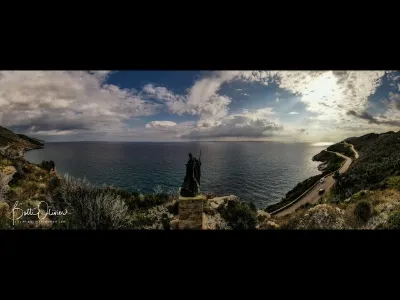
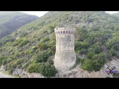
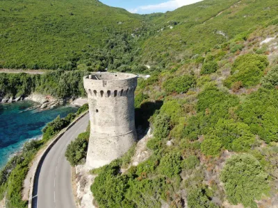
Erbalunga is a charming village full of character on the Corsican coast, notable for its ruined Genoese tower built in the 16th century on a rock at the entrance to its harbor. The tower is listed as a Historic Monument.
Its harbor, which was also a shelter for Phoenician and Roman sailors in Antiquity, has become a place of charm. With sunshine almost all year round, a good mood and a gentle way of life reign in this village.
Every summer, thousands of tourists come to enjoy and photograph the landscape. This former fishing port has become one of the best-known images of Corsica.
Map and restricted areas
Open in the main mapNearby aerodromes
Open aerodromes within 25 km of the spot, heliports included, with their distance and direction from the spot. Near an aerodrome, drone flying is prohibited or height-limited: check the UAS zones map.
| Aerodrome | Type | Distance | Elevation | Difference |
|---|---|---|---|---|
| Bastia-Poretta Airport | Airport | 25 km S | 8 m | spot 6 m lower |
Aviation weather (METAR and TAF)
LFKB – Bastia-Poretta Airport VFR
METAR
METAR LFKB 210700Z AUTO 26004KT CAVOK ///// Q1017 NOSIG
- Wind
- 260°, 7 km/h
- Visibility
- 10 km or more
- Clouds
- –
- Temperature
- –
- QNH
- 1017 hPa
- Flight category
- VFR: ceiling > 3,000 ft and visibility > 5 mi
TAF
TAF LFKB 210200Z 2103/2203 27020G35KT CAVOK TX21/2111Z TN16/2105Z TEMPO 2103/2104 27030G45KT BECMG 2103/2104 VRB05KT
| Period (local time) | Change | Wind | Visibility | Weather | Clouds |
|---|---|---|---|---|---|
| 21/11 04:00 → 22/11 04:00 | Initial conditions | 270°, 37 km/h, gusts 65 km/h | 10 km or more | No significant cloud | |
| 21/11 04:00 → 22/11 04:00 | Becoming | Variable, 9 km/h | 10 km or more | No significant cloud | |
| 21/11 04:00 → 21/11 05:00 | Temporarily | 270°, 56 km/h, gusts 83 km/h |
Weather and Kp index
| Day | Weather | Temp. min. / max. | Wind | Rain | Max Kp |
|---|---|---|---|---|---|
| Sat 21 Nov | Fair | 13° / 19° | 48 km/h W | – | 2 |
| Sun 22 Nov | Showers | 14° / 18° | 59 km/h W | 3.0 mm | 2 |
| Mon 23 Nov | Fair | 12° / 16° | 62 km/h W | – | 4 |
| Tue 24 Nov | Cloudy | 11° / 15° | 22 km/h W | 0.5 mm | 2 |
| Wed 25 Nov | Rain | 12° / 14° | 11 km/h E | 11 mm | – |
| Thu 26 Nov | Rain | 11° / 14° | 5 km/h NE | 7.8 mm | – |
| Fri 27 Nov | Partly cloudy | 10° / 14° | 11 km/h N | 7.9 mm | – |
Hour by hour: Saturday 21 November
| Time | Weather | Temp. | Wind | Rain | Clouds | Kp |
|---|---|---|---|---|---|---|
| 08:00 | Partly cloudy | 15° | 46 km/h W | – | 86 % | 2 |
| 09:00 | Partly cloudy | 16° | 46 km/h W | – | 38 % | 2 |
| 10:00 | Partly cloudy | 17° | 47 km/h W | – | 42 % | 2 |
| 11:00 | Partly cloudy | 18° | 48 km/h W | – | 52 % | 2 |
| 12:00 | Partly cloudy | 18° | 47 km/h W | – | 41 % | 2 |
| 13:00 | Fair | 19° | 46 km/h W | – | 26 % | 1 |
| 14:00 | Clear sky | 18° | 45 km/h W | – | 8 % | 1 |
| 15:00 | Clear sky | 18° | 44 km/h W | – | 5 % | 1 |
| 16:00 | Fair | 17° | 41 km/h W | – | 17 % | 2 |
| 17:00 | Fair | 15° | 40 km/h W | – | 16 % | 2 |
| 18:00 | Fair | 15° | 37 km/h W | – | 16 % | 2 |
| 19:00 | Fair | 14° | 35 km/h W | – | 37 % | 2 |
| 20:00 | Fair | 14° | 31 km/h W | – | 28 % | 2 |
| 21:00 | Partly cloudy | 14° | 23 km/h SW | – | 56 % | 2 |
| 22:00 | Clear sky | 13° | 15 km/h SE | – | 12 % | 2 |
Hour by hour: Sunday 22 November
| Time | Weather | Temp. | Wind | Rain | Clouds | Kp |
|---|---|---|---|---|---|---|
| 06:00 | Cloudy | 15° | 16 km/h SE | – | 99 % | 2 |
| 07:00 | Cloudy | 15° | 15 km/h SE | – | 88 % | 2 |
| 08:00 | Partly cloudy | 15° | 13 km/h SE | – | 71 % | 2 |
| 09:00 | Cloudy | 16° | 16 km/h SE | – | 92 % | 2 |
| 10:00 | Partly cloudy | 16° | 14 km/h SE | – | 58 % | 2 |
| 11:00 | Partly cloudy | 17° | 16 km/h SE | – | 49 % | 2 |
| 12:00 | Showers | 18° | 14 km/h S | 1.9 mm | 75 % | 2 |
| 13:00 | Showers | 17° | 49 km/h SW | 1.1 mm | 83 % | 2 |
| 14:00 | Cloudy | 17° | 41 km/h W | – | 100 % | 2 |
| 15:00 | Partly cloudy | 17° | 48 km/h W | – | 52 % | 2 |
| 16:00 | Clear sky | 16° | 56 km/h W | – | 6 % | 2 |
| 17:00 | Clear sky | 16° | 57 km/h W | – | 1 % | 2 |
| 18:00 | Fair | 16° | 55 km/h W | – | 30 % | 2 |
| 19:00 | Fair | 16° | 55 km/h W | – | 16 % | 2 |
| 20:00 | Clear sky | 16° | 53 km/h W | – | 7 % | 2 |
| 21:00 | Clear sky | 15° | 55 km/h W | – | 8 % | 2 |
| 22:00 | Clear sky | 15° | 58 km/h W | – | 8 % | 2 |
Sunrise and sunset
| Day | Dawn | Sunrise | Golden hour | Sunset | Dusk | Day length |
|---|---|---|---|---|---|---|
| Sat 21 Nov | 06:50 | 07:21 | 07:21–08:05 · 16:11–16:55 | 16:55 | 17:25 | 9 h 33 |
| Sun 22 Nov | 06:52 | 07:22 | 07:22–08:06 · 16:10–16:54 | 16:54 | 17:25 | 9 h 31 |
| Mon 23 Nov | 06:53 | 07:24 | 07:24–08:07 · 16:10–16:53 | 16:53 | 17:24 | 9 h 29 |
| Tue 24 Nov | 06:54 | 07:25 | 07:25–08:09 · 16:09–16:53 | 16:53 | 17:24 | 9 h 27 |
| Wed 25 Nov | 06:55 | 07:26 | 07:26–08:10 · 16:08–16:52 | 16:52 | 17:23 | 9 h 26 |
| Thu 26 Nov | 06:56 | 07:27 | 07:27–08:11 · 16:07–16:52 | 16:52 | 17:23 | 9 h 24 |
| Fri 27 Nov | 06:57 | 07:28 | 07:28–08:13 · 16:07–16:51 | 16:51 | 17:22 | 9 h 22 |


Reviews
Log in to review this spot. Log in · Create a free account
No reviews yet. Share yours!