

Former Dreux sanatorium

No reviews yet
Have you flown here? Share your experience with other pilots.
+ Write the first reviewDescription
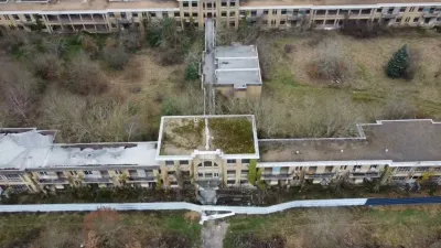
The Dreux Sanatorium, known locally as the Bas-Buissons sanatorium, is a very large complex of 8 building blocks spread over more than 40 hectares. The architectural complex is located northwest of Dreux. Very narrow, the buildings are long and face due south to get maximum sunlight. It is a typical 1930s architecture known as heliotropic: benefiting from fresh air and the restorative virtues of the sun. . During the First World War, tuberculosis wreaked havoc because it is an extremely contagious disease, and soldiers were heavily affected, due to crowding and the harsh conditions they were forced to endure. . The Dreux sanatorium was built hastily from 1928 to 1932 to fight the spread of tuberculosis in the Drouais. In 1935 the site was extended with a convalescent home for women. At its peak in those years, about 1,000 people could be accommodated on site, but it was generally used at a third of its capacity. . During the Second World War, it served as a military hospital run by the American army. In the 1960s, when tuberculosis had been eradicated, the buildings were used as a retirement home and a medical-educational institute from 1962 to 1980. The site closed for good in 1990. In 1999, when the site was completely abandoned, the town of Dreux bought the land and its painful legacy for one symbolic franc. . Several sections exist in this place: a preventorium (1931), a sanatorium (1932), a rest home (1935), and a geriatric center, which was built in 1939 but never put into service because of the Second World War.
Map and restricted areas
Open in the main mapNearby aerodromes
Open aerodromes within 25 km of the spot, heliports included, with their distance and direction from the spot. Near an aerodrome, drone flying is prohibited or height-limited: check the UAS zones map.
| Aerodrome | Type | Distance | Elevation | Difference |
|---|---|---|---|---|
| Centre Hospitalier Heliport | Heliport | 4.9 km SE | 137 m | same altitude as the spot |
| Aérodrome de Dreux - Vernouillet | Aerodrome | 6.1 km S | 135 m | same altitude as the spot |
| St André De L'eure Airfield | Aerodrome | 17 km N | 149 m | spot 14 m lower |
Aviation weather (METAR and TAF)
LFOE – Évreux-Fauville (BA 105) Air Base LIFR
METAR
METAR LFOE 210630Z AUTO 12005KT 0900 0800 R22/0900N FG VV/// 07/07 Q1018 BECMG 0400 FG
- Wind
- 120°, 9 km/h
- Visibility
- 900 m
- Weather
- Fog
- Clouds
- –
- Temperature
- 7 °C, dew point 7 °C
- QNH
- 1018 hPa
- Flight category
- LIFR: ceiling < 500 ft or visibility < 1 mi
TAF
TAF AMD LFOE 210529Z 2105/2203 11004KT 0400 FG VV/// BECMG 2111/2113 8000 NSW BKN005 BECMG 2115/2117 OVC015 BECMG 2123/2201 4000 RA BKN004
| Period (local time) | Change | Wind | Visibility | Weather | Clouds |
|---|---|---|---|---|---|
| 21/11 06:00 → 21/11 12:00 | Initial conditions | 110°, 7 km/h | 400 m | Fog | |
| 21/11 12:00 → 21/11 16:00 | Becoming | 110°, 7 km/h | 8 km | No significant weather | Broken (5-7/8) at 500 ft (150 m) |
| 21/11 16:00 → 22/11 00:00 | Becoming | 110°, 7 km/h | 8 km | No significant weather | Overcast (8/8) at 1,500 ft (460 m) |
| 22/11 00:00 → 22/11 04:00 | Becoming | 110°, 7 km/h | 4.0 km | Rain | Broken (5-7/8) at 400 ft (120 m) |
Weather and Kp index
Sunrise and sunset
| Day | Dawn | Sunrise | Golden hour | Sunset | Dusk | Day length |
|---|---|---|---|---|---|---|
| Sat 21 Nov | 07:37 | 08:12 | 08:12–09:03 · 16:18–17:09 | 17:09 | 17:44 | 8 h 56 |
| Sun 22 Nov | 07:39 | 08:14 | 08:14–09:05 · 16:17–17:08 | 17:08 | 17:43 | 8 h 53 |
| Mon 23 Nov | 07:40 | 08:15 | 08:15–09:07 · 16:15–17:07 | 17:07 | 17:42 | 8 h 51 |
| Tue 24 Nov | 07:41 | 08:17 | 08:17–09:08 · 16:14–17:06 | 17:06 | 17:41 | 8 h 49 |
| Wed 25 Nov | 07:43 | 08:18 | 08:18–09:10 · 16:13–17:05 | 17:05 | 17:40 | 8 h 46 |
| Thu 26 Nov | 07:44 | 08:20 | 08:20–09:12 · 16:12–17:04 | 17:04 | 17:40 | 8 h 44 |
| Fri 27 Nov | 07:45 | 08:21 | 08:21–09:13 · 16:11–17:04 | 17:04 | 17:39 | 8 h 42 |
Reviews
Log in to review this spot. Log in · Create a free account
No reviews yet. Share yours!