

Zuydcoote Battery

No reviews yet
Have you flown here? Share your experience with other pilots.
+ Write the first reviewDescription
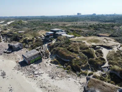
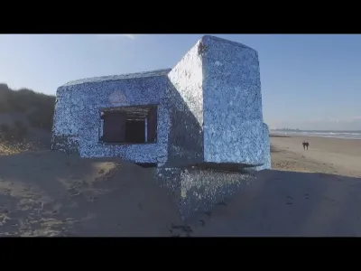
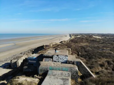
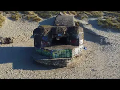
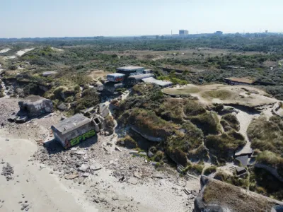
Leffrinckoucke beach on the Opal Coast, in the heart of the Dunes de Flandre. Located between the seaside resorts of Malo les Bains, very close to Dunkerque, and Zuydcoote. The Zuydcoote battery, also called the East battery, is a work of the Séré de Rivières system, built from 1877 to 1878 as an annex to the Fort des Dunes. It is named so because it was tasked with defending the Zuydcoote pass. Located in the municipality of Leffrinckoucke, 5 km east of Dunkerque, it is built entirely of yellow brick. The work was integrated into the Maginot Line, then supplemented with blockhouses of the Atlantic Wall. Parking nearby.
Map and restricted areas
Open in the main mapNearby aerodromes
Open aerodromes within 25 km of the spot, heliports included, with their distance and direction from the spot. Near an aerodrome, drone flying is prohibited or height-limited: check the UAS zones map.
| Aerodrome | Type | Distance | Elevation | Difference |
|---|---|---|---|---|
| Centre Hospitalier Heliport | Heliport | 4.5 km SW | 17 m | same altitude as the spot |
| Dunkerque – Les Moëres Airfield | Aerodrome | 7.5 km E | -1 m | spot 14 m higher |
| Koksijde Air Base | Airport | 15 km E | 6 m | spot 7 m higher |
| Sint-Augustinus heliport | Heliport | 16 km E | 4 m | spot 9 m higher |
| Veurne heliport | Heliport | 17 km E | 25 m | spot 12 m lower |
Aviation weather (METAR and TAF)
EBOS – Ostend-Bruges International Airport VFR
METAR
METAR EBOS 211120Z 20004KT 9999 FEW034 09/04 Q1019 NOSIG
- Wind
- 200°, 7 km/h
- Visibility
- 10 km or more
- Clouds
- Few (1-2/8) at 3,400 ft (1040 m)
- Temperature
- 9 °C, dew point 4 °C
- QNH
- 1019 hPa
- Flight category
- VFR: ceiling > 3,000 ft and visibility > 5 mi
TAF
TAF EBOS 211100Z 2112/2218 16004KT CAVOK PROB30 2204/2207 4500 BR MIFG BECMG 2206/2208 08011KT
| Period (local time) | Change | Wind | Visibility | Weather | Clouds |
|---|---|---|---|---|---|
| 21/11 13:00 → 22/11 07:00 | Initial conditions | 160°, 7 km/h | 10 km or more | No significant weather | No significant cloud |
| 22/11 05:00 → 22/11 08:00 | probability 30% | 4.5 km | Mist ; shallow fog | ||
| 22/11 07:00 → 22/11 19:00 | Becoming | 080°, 20 km/h | 10 km or more | No significant weather | No significant cloud |
Weather and Kp index
| Day | Weather | Temp. min. / max. | Wind | Rain | Max Kp |
|---|---|---|---|---|---|
| Sat 21 Nov | Clear sky | 5° / 9° | 22 km/h SE | – | 2 |
| Sun 22 Nov | Partly cloudy | 5° / 7° | 39 km/h E | – | 2 |
| Mon 23 Nov | Clear sky | 2° / 5° | 33 km/h E | – | 4 |
| Tue 24 Nov | Fair | 0° / 3° | 26 km/h SE | – | 2 |
| Wed 25 Nov | Cloudy | 1° / 3° | 33 km/h E | – | – |
| Thu 26 Nov | Cloudy | 0° / 2° | 28 km/h E | – | – |
| Fri 27 Nov | Partly cloudy | -1° / 1° | 21 km/h SE | – | – |
Hour by hour: Saturday 21 November
| Time | Weather | Temp. | Wind | Rain | Clouds | Kp |
|---|---|---|---|---|---|---|
| 12:00 | Clear sky | 8° | 13 km/h S | – | 0 % | 2 |
| 13:00 | Clear sky | 9° | 11 km/h S | – | 0 % | 1 |
| 14:00 | Clear sky | 9° | 11 km/h SE | – | 0 % | 1 |
| 15:00 | Clear sky | 9° | 12 km/h SE | – | 0 % | 1 |
| 16:00 | Clear sky | 9° | 14 km/h SE | – | 1 % | 2 |
| 17:00 | Clear sky | 8° | 18 km/h SE | – | 0 % | 2 |
| 18:00 | Clear sky | 7° | 21 km/h E | – | 0 % | 2 |
| 19:00 | Clear sky | 7° | 22 km/h SE | – | 0 % | 2 |
| 20:00 | Clear sky | 6° | 22 km/h SE | – | 0 % | 2 |
| 21:00 | Clear sky | 6° | 20 km/h SE | – | 0 % | 2 |
| 22:00 | Clear sky | 6° | 22 km/h E | – | 0 % | 2 |
Hour by hour: Sunday 22 November
| Time | Weather | Temp. | Wind | Rain | Clouds | Kp |
|---|---|---|---|---|---|---|
| 06:00 | Partly cloudy | 5° | 31 km/h E | – | 100 % | 2 |
| 07:00 | Partly cloudy | 5° | 33 km/h E | – | 100 % | 2 |
| 08:00 | Partly cloudy | 5° | 35 km/h E | – | 100 % | 2 |
| 09:00 | Partly cloudy | 5° | 36 km/h E | – | 100 % | 2 |
| 10:00 | Partly cloudy | 5° | 37 km/h E | – | 100 % | 2 |
| 11:00 | Partly cloudy | 6° | 37 km/h E | – | 99 % | 2 |
| 12:00 | Partly cloudy | 6° | 39 km/h E | – | 99 % | 2 |
| 13:00 | Partly cloudy | 7° | 39 km/h E | – | 100 % | 2 |
| 14:00 | Partly cloudy | 7° | 37 km/h E | – | 100 % | 2 |
| 15:00 | Partly cloudy | 7° | 38 km/h E | – | 97 % | 2 |
| 16:00 | Partly cloudy | 7° | 38 km/h E | – | 92 % | 2 |
| 17:00 | Partly cloudy | 7° | 37 km/h E | – | 97 % | 2 |
| 18:00 | Partly cloudy | 7° | 37 km/h E | – | 95 % | 2 |
| 19:00 | Partly cloudy | 6° | 37 km/h E | – | 98 % | 2 |
| 20:00 | Partly cloudy | 6° | 36 km/h E | – | 98 % | 2 |
| 21:00 | Partly cloudy | 6° | 34 km/h E | – | 98 % | 2 |
| 22:00 | Partly cloudy | 6° | 33 km/h E | – | 76 % | 2 |
Sunrise and sunset
| Day | Dawn | Sunrise | Golden hour | Sunset | Dusk | Day length |
|---|---|---|---|---|---|---|
| Sat 21 Nov | 07:39 | 08:17 | 08:17–09:11 · 16:01–16:56 | 16:56 | 17:33 | 8 h 39 |
| Sun 22 Nov | 07:41 | 08:18 | 08:18–09:13 · 15:59–16:55 | 16:55 | 17:32 | 8 h 36 |
| Mon 23 Nov | 07:42 | 08:20 | 08:20–09:15 · 15:58–16:53 | 16:53 | 17:31 | 8 h 33 |
| Tue 24 Nov | 07:44 | 08:21 | 08:21–09:17 · 15:57–16:52 | 16:52 | 17:30 | 8 h 31 |
| Wed 25 Nov | 07:45 | 08:23 | 08:23–09:19 · 15:56–16:52 | 16:52 | 17:29 | 8 h 28 |
| Thu 26 Nov | 07:47 | 08:24 | 08:24–09:21 · 15:54–16:51 | 16:51 | 17:28 | 8 h 26 |
| Fri 27 Nov | 07:48 | 08:26 | 08:26–09:22 · 15:53–16:50 | 16:50 | 17:28 | 8 h 24 |

Reviews
Log in to review this spot. Log in · Create a free account
No reviews yet. Share yours!