

Anse Dufour








No reviews yet
Have you flown here? Share your experience with other pilots.
+ Write the first reviewDescription
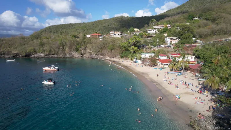
The pleasure of a getaway to Anse Dufour and the neighboring Anse Noire begins at the top of the morne Bigot, when you take the rough ribbon of asphalt that winds along the sides of the ravine and sometimes drops steeply toward the shore. A few majestic trees, isolated houses, a hamlet, lots of bends, a few bumps, and then suddenly, around a turn, a long straight descent plunging toward the ocean with a stunning panoramic view of the Caribbean Sea and its turquoise waters.
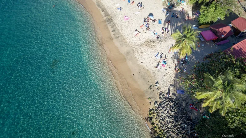
At the foot of the rocky spur where the road ends, hidden by a curtain of trees, you can make out through the branches a small cove of golden sand, in front of which a few fishing boats lazily sit at anchor. A staircase and a ramp for wheelchair users provide access.
Below, a few fishermen's huts are huddled together on the left, two bar-restaurants with an old-fashioned atmosphere are on the right, and then the beach, small but superb, with its gommiers (traditional canoes) balanced on their logs, always ready to head out to sea.
Map and restricted areas
Open in the main mapNearby aerodromes
Open aerodromes within 25 km of the spot, heliports included, with their distance and direction from the spot. Near an aerodrome, drone flying is prohibited or height-limited: check the UAS zones map.
| Aerodrome | Type | Distance | Elevation |
|---|---|---|---|
| Martinique Aimé Césaire International Airport | Major airport | 12 km NE | 5 m |
| Bellefontaine Heliport | Heliport | 17 km NW | 4 m |
Aviation weather (METAR and TAF)
TFFF – Martinique Aimé Césaire International Airport MVFR
METAR
METAR TFFF 211000Z AUTO VRB03KT 9999 BKN022 BKN029 26/24 Q1012 TEMPO 3500 SHRA FEW018CB BKN025TCU
- Wind
- Variable, 6 km/h
- Visibility
- 10 km or more
- Clouds
- Broken (5-7/8) at 2,200 ft (670 m) ; Broken (5-7/8) at 2,900 ft (880 m)
- Temperature
- 26 °C, dew point 24 °C
- QNH
- 1012 hPa
- Flight category
- MVFR: ceiling 1,000–3,000 ft or visibility 3–5 mi
TAF
TAF TFFF 210500Z 2106/2206 08005KT 9999 SCT023 BKN070 PROB40 TEMPO 2106/2120 3500 SHRA FEW018CB BKN025TCU PROB40 TEMPO 2106/2110 VRB02KT BECMG 2112/2114 08015KT PROB30 TEMPO 2203/2206 4000 SHRA SCT018TCU BKN025
| Period (local time) | Change | Wind | Visibility | Weather | Clouds |
|---|---|---|---|---|---|
| 21/11 02:00 → 21/11 08:00 | Initial conditions | 080°, 9 km/h | 10 km or more | Scattered (3-4/8) at 2,300 ft (700 m) ; Broken (5-7/8) at 7,000 ft (2130 m) | |
| 21/11 02:00 → 21/11 06:00 | Temporarily, probability 40% | Variable, 4 km/h | |||
| 21/11 02:00 → 21/11 16:00 | Temporarily, probability 40% | 3.5 km | Showers of rain | Few (1-2/8) at 1,800 ft (550 m) (cumulonimbus) ; Broken (5-7/8) at 2,500 ft (760 m) (towering cumulus) | |
| 21/11 08:00 → 22/11 02:00 | Becoming | 080°, 28 km/h | 10 km or more | Scattered (3-4/8) at 2,300 ft (700 m) ; Broken (5-7/8) at 7,000 ft (2130 m) | |
| 21/11 23:00 → 22/11 02:00 | Temporarily, probability 30% | 4.0 km | Showers of rain | Scattered (3-4/8) at 1,800 ft (550 m) (towering cumulus) ; Broken (5-7/8) at 2,500 ft (760 m) |
Weather and Kp index
Sunrise and sunset
| Day | Dawn | Sunrise | Golden hour | Sunset | Dusk | Day length |
|---|---|---|---|---|---|---|
| Sat 21 Nov | 05:46 | 06:08 | 06:08–06:39 · 17:02–17:32 | 17:32 | 17:55 | 11 h 24 |
| Sun 22 Nov | 05:46 | 06:09 | 06:09–06:39 · 17:02–17:32 | 17:32 | 17:55 | 11 h 23 |
| Mon 23 Nov | 05:47 | 06:09 | 06:09–06:40 · 17:02–17:32 | 17:32 | 17:55 | 11 h 23 |
| Tue 24 Nov | 05:47 | 06:10 | 06:10–06:40 · 17:02–17:32 | 17:32 | 17:55 | 11 h 22 |
| Wed 25 Nov | 05:48 | 06:10 | 06:10–06:41 · 17:02–17:33 | 17:33 | 17:55 | 11 h 22 |
| Thu 26 Nov | 05:48 | 06:11 | 06:11–06:41 · 17:02–17:33 | 17:33 | 17:55 | 11 h 21 |
| Fri 27 Nov | 05:49 | 06:11 | 06:11–06:42 · 17:02–17:33 | 17:33 | 17:56 | 11 h 21 |




Reviews
Log in to review this spot. Log in · Create a free account
No reviews yet. Share yours!