

Mont Bignone - Sanremo - Liguria
No reviews yet
Have you flown here? Share your experience with other pilots.
+ Write the first reviewDescription
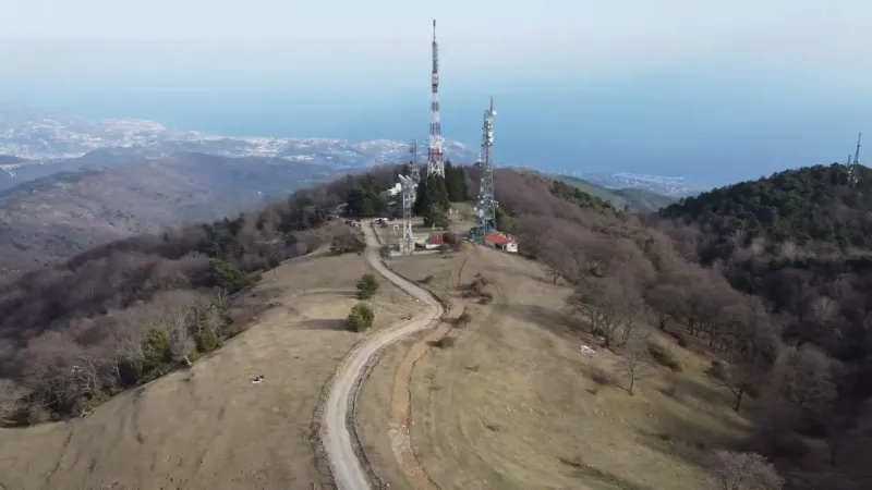
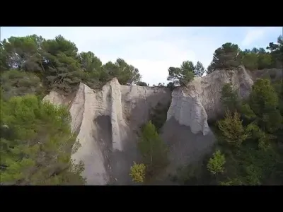
Mont Bignone - 1299 meters - Sanremo - Liguria - Italy - 4K/UHD drone - March 2022
Mont Bignone is a peak in the Ligurian Alps located in the province of Imperia in Liguria. At 1299 m of altitude, it overlooks the city of San Remo to the north. It is part of the San Romolo and Monte Bignone natural park. The summit hosts the highest castle in the whole San Remo valley, built by the Intemeli of Liguria, probably to defend the surrounding grazing areas. Remains of pre-Roman pottery of local manufacture, as well as amphorae dating from the 5th and 4th centuries BC, now kept in the San Remo museum, were found on this summit.
The people of Sanremo took refuge on the slopes of this peak in the 10th century during the invasions of the town, near the cave where the bishop and hermit Romulus of Genoa had made his home. The name of this saint would explain the name of the San Remo festival. In addition, around this cave is now the hamlet of San Remolo, made up of a few houses surrounding a large meadow.
Today, the summit of the mountain hosts many telecommunication relays, a few scattered houses, a small church and the abandoned station of the San Remo - Monte Bignone cable car.
Between 1936 and 1981, a cable car connected San Remo to the summit of the mountain. The line was 7,688 m long and the trip took about 40 minutes. Two transfer stations were set up, one near the Golf Course and the other sheltered in the hamlet of San Romolo. Between this last station and the summit station, the longest suspended cable between two pylons in Europe was built, measuring 1,700 m.
The line, conceived in 1929 and started at the end of 1935, bore the hallmark of Pietro Agosti and was built by the Compagnia Italiana Funivie, an arduous undertaking that at the time represented the longest cable car span in the world. The motors used were the best engineering of the time: they suffered no major problems during the 45 years they were in uninterrupted service, and even when the line was abandoned, they were still working perfectly.
The cable car was built in the shadow of the Second World War, when elite Russian tourism had already begun to decline, and that of the English had been definitively blocked by the international sanctions against Italy, so much so that the inauguration of the line on October 28, 1936 went almost unnoticed.
Map and restricted areas
Open in the main mapAviation weather (METAR and TAF)
LIMG – Villanova D'Albenga International Airport VFR
METAR
METAR LIMG 210950Z VRB02KT CAVOK 13/10 Q1016
- Wind
- Variable, 4 km/h
- Visibility
- 10 km or more
- Clouds
- –
- Temperature
- 13 °C, dew point 10 °C
- QNH
- 1016 hPa
- Flight category
- VFR: ceiling > 3,000 ft and visibility > 5 mi
TAF
TAF LIMG 210500Z 2108/2206 VRB05KT CAVOK
| Period (local time) | Change | Wind | Visibility | Weather | Clouds |
|---|---|---|---|---|---|
| 21/11 09:00 → 22/11 07:00 | Initial conditions | Variable, 9 km/h | 10 km or more | No significant weather | No significant cloud |
Weather and Kp index
| Day | Weather | Temp. min. / max. | Wind | Rain | Max Kp |
|---|---|---|---|---|---|
| Sat 21 Nov | Partly cloudy | 4° / 12° | 7 km/h NW | – | 2 |
| Sun 22 Nov | Light rain | 2° / 9° | 35 km/h NW | 16 mm | 2 |
| Mon 23 Nov | Clear sky | 0° / 12° | 30 km/h NW | – | 4 |
| Tue 24 Nov | Cloudy | -1° / 8° | 9 km/h N | 0.6 mm | 2 |
| Wed 25 Nov | Sleet | 0° / 3° | 16 km/h N | 22 mm | – |
| Thu 26 Nov | Partly cloudy | -0° / 7° | 10 km/h N | 7.1 mm | – |
| Fri 27 Nov | Clear sky | -5° / 7° | 9 km/h N | – | – |
Hour by hour: Saturday 21 November
| Time | Weather | Temp. | Wind | Rain | Clouds | Kp |
|---|---|---|---|---|---|---|
| 12:00 | Partly cloudy | 12° | 6 km/h S | – | 88 % | 2 |
| 13:00 | Partly cloudy | 12° | 5 km/h S | – | 79 % | 1 |
| 14:00 | Fair | 12° | 5 km/h S | – | 32 % | 1 |
| 15:00 | Clear sky | 12° | 5 km/h S | – | 8 % | 1 |
| 16:00 | Fair | 10° | 4 km/h S | – | 23 % | 2 |
| 17:00 | Fair | 7° | 4 km/h N | – | 37 % | 2 |
| 18:00 | Partly cloudy | 6° | 5 km/h N | – | 59 % | 2 |
| 19:00 | Partly cloudy | 5° | 5 km/h NW | – | 58 % | 2 |
| 20:00 | Partly cloudy | 4° | 6 km/h NW | – | 39 % | 2 |
| 21:00 | Partly cloudy | 4° | 7 km/h NW | – | 48 % | 2 |
| 22:00 | Partly cloudy | 4° | 6 km/h N | – | 94 % | 2 |
Hour by hour: Sunday 22 November
| Time | Weather | Temp. | Wind | Rain | Clouds | Kp |
|---|---|---|---|---|---|---|
| 06:00 | Rain | 6° | 4 km/h N | 0.8 mm | 100 % | 2 |
| 07:00 | Heavy rain | 6° | 5 km/h N | 2.8 mm | 100 % | 2 |
| 08:00 | Heavy rain | 6° | 5 km/h NW | 3.5 mm | 100 % | 2 |
| 09:00 | Heavy rain | 6° | 5 km/h NW | 2.9 mm | 100 % | 2 |
| 10:00 | Heavy rain | 6° | 9 km/h NW | 2.9 mm | 100 % | 2 |
| 11:00 | Light rain | 7° | 12 km/h W | 0.3 mm | 100 % | 2 |
| 12:00 | Showers | 9° | 9 km/h SW | 0.2 mm | 84 % | 2 |
| 13:00 | Light rain | 8° | 13 km/h S | 0.1 mm | 97 % | 2 |
| 14:00 | Fog | 8° | 9 km/h S | – | 98 % | 2 |
| 15:00 | Fog | 8° | 14 km/h E | – | 96 % | 2 |
| 16:00 | Fog | 8° | 15 km/h E | – | 61 % | 2 |
| 17:00 | Fog | 7° | 16 km/h E | – | 62 % | 2 |
| 18:00 | Fog | 7° | 17 km/h NE | – | 73 % | 2 |
| 19:00 | Fog | 6° | 22 km/h N | – | 62 % | 2 |
| 20:00 | Fog | 6° | 31 km/h NW | – | 38 % | 2 |
| 21:00 | Fair | 5° | 33 km/h NW | – | 18 % | 2 |
| 22:00 | Clear sky | 4° | 35 km/h NW | – | 8 % | 2 |
Sunrise and sunset
| Day | Dawn | Sunrise | Golden hour | Sunset | Dusk | Day length |
|---|---|---|---|---|---|---|
| Sat 21 Nov | 07:00 | 07:31 | 07:31–08:16 · 16:14–16:58 | 16:58 | 17:30 | 9 h 27 |
| Sun 22 Nov | 07:01 | 07:33 | 07:33–08:17 · 16:13–16:58 | 16:58 | 17:29 | 9 h 25 |
| Mon 23 Nov | 07:02 | 07:34 | 07:34–08:19 · 16:12–16:57 | 16:57 | 17:29 | 9 h 23 |
| Tue 24 Nov | 07:03 | 07:35 | 07:35–08:20 · 16:11–16:56 | 16:56 | 17:28 | 9 h 21 |
| Wed 25 Nov | 07:04 | 07:36 | 07:36–08:21 · 16:11–16:56 | 16:56 | 17:28 | 9 h 19 |
| Thu 26 Nov | 07:06 | 07:37 | 07:37–08:23 · 16:10–16:55 | 16:55 | 17:27 | 9 h 17 |
| Fri 27 Nov | 07:07 | 07:39 | 07:39–08:24 · 16:09–16:55 | 16:55 | 17:27 | 9 h 16 |
Reviews
Log in to review this spot. Log in · Create a free account
No reviews yet. Share yours!