

Col du Blainon - Auron
No reviews yet
Have you flown here? Share your experience with other pilots.
+ Write the first reviewDescription
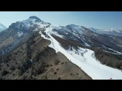
Col du Blainon - 2014 meters - Auron - Côte d'Azur - 4K/UHD drone - March 2022
Auron is a winter sports resort, created in 1937 and located at 1,600 m of altitude, in the municipality of Saint-Étienne-de-Tinée, in the Alpes-Maritimes department and the Provence-Alpes-Côte d'Azur region. Its inhabitants are called the Auronais. This former alpine pasture village of the Haut Haut Pays niçois, once the wheat granary of Saint-Étienne-de-Tinée, is today a lively winter and summer resort, about 1h30 by road from Nice, in the heart of the Mercantour massif, close to the national park of the same name. The highest and closest peak to the resort is the Cime de Las Donnas, peaking at 2474 meters of altitude. The ski area ranges from 1,250 meters to 2,450 meters of altitude and spreads over 135 kilometers of slopes, making it the largest in the Alpes-Maritimes department.
Map and restricted areas
Open in the main mapNearby aerodromes
Open aerodromes within 25 km of the spot, heliports included, with their distance and direction from the spot. Near an aerodrome, drone flying is prohibited or height-limited: check the UAS zones map.
| Aerodrome | Type | Distance | Elevation | Difference |
|---|---|---|---|---|
| Altisurface de Valberg | Aerodrome | 11 km S | 683 m | spot 1,410 m higher |
| Altisurface d'Isola 2000 | Aerodrome | 18 km E | 2,500 m | spot 407 m lower |
Aviation weather (METAR and TAF)
No METAR station within 50 km.
Weather and Kp index
Sunrise and sunset
| Day | Dawn | Sunrise | Golden hour | Sunset | Dusk | Day length |
|---|---|---|---|---|---|---|
| Sat 21 Nov | 07:04 | 07:36 | 07:36–08:20 · 16:16–17:01 | 17:01 | 17:32 | 9 h 25 |
| Sun 22 Nov | 07:05 | 07:37 | 07:37–08:22 · 16:15–17:00 | 17:00 | 17:32 | 9 h 23 |
| Mon 23 Nov | 07:06 | 07:38 | 07:38–08:23 · 16:14–16:59 | 16:59 | 17:31 | 9 h 21 |
| Tue 24 Nov | 07:07 | 07:39 | 07:39–08:25 · 16:13–16:59 | 16:59 | 17:30 | 9 h 19 |
| Wed 25 Nov | 07:09 | 07:40 | 07:40–08:26 · 16:12–16:58 | 16:58 | 17:30 | 9 h 17 |
| Thu 26 Nov | 07:10 | 07:42 | 07:42–08:27 · 16:12–16:57 | 16:57 | 17:29 | 9 h 15 |
| Fri 27 Nov | 07:11 | 07:43 | 07:43–08:29 · 16:11–16:57 | 16:57 | 17:29 | 9 h 13 |
Nearby on Wikipedia
Nearby spots
 Mountain
Auron - Alpes Maritimes - Baisse de Colombier
 Mountain
Las Donnas - 2474 Meters - Auron
 Mountain
The summit of Auron and the Cime de la Bercha
 Mountain
Saint Dalmas le Selvage
 Mountain
Saint Delmas le Selvage
 Mountain
The alpine pastures of the Alpes-Maritimes, an ode to wild beauty by 4K drone
Reviews
Log in to review this spot. Log in · Create a free account
No reviews yet. Share yours!