

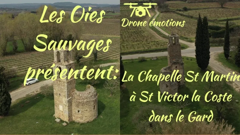
Chapelle Saint Martin at St Victor la Coste
No reviews yet
Have you flown here? Share your experience with other pilots.
+ Write the first reviewDescription
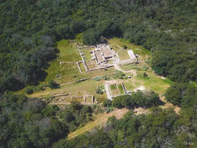
Location The chapel stands in the middle of the plain, near a spring and its wash house, northwest of the village of Saint-Victor-la-Coste, along the D145 departmental road, which links Connaux to Saint-Laurent-des-Arbres.
History The Chapelle Saint-Martin probably occupies the site of an ancient pagan temple built along a Roman road: on one side, Saint-Martin lies along a road that once linked the Nîmes-Alba road to the roads running along the Rhône valley, and on the other, a Roman funerary stele reused in the base of one of the chapel's pillars attests to the pagan origin of the site.
The current chapel dates from the 11th and 12th centuries: its construction began around 1050, in a place where the regional market was held. When this market was moved to Bagnols in 1223 on the orders of King Louis VIII (who also had the castle of the Count of Sabran, which overlooked the village, demolished), the chapel was abandoned by the markets and pilgrims and did not survive.
The priory is mentioned under the names Ad Sanctum Victorem in 1220, Sanctus-Victor de Costa in 1384 and Prieuré Sainct-Victor de la Coste in 1620.
It belonged to the viguerie of Bagnols and the diocese of Uzès. The Priory of Saint-Victor was a regular priory, united with the cathedral chapter of Uzès: the provost of this chapter held the right of appointment. Heritage status The chapel has been listed as a historic monument since 23 October 1980.
The ruins of the chapel are now owned by the municipality.
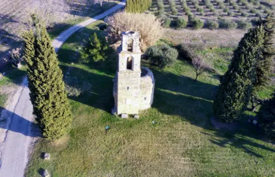
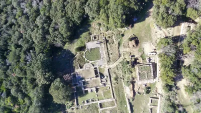
Architecture All that remains today of the Chapelle Saint-Martin are the ruins of the chevet and the bell tower, so its overall plan is not known.
Exterior architecture The bell tower The bell tower has three levels: each one is set back from the level below and separated from it by a beveled stone string course.
The lower level is built of rubble stone and has stone corner quoins at the southeast. It is pierced by a small window with tooled jambs and a monolithic lintel, as well as by putlog holes (holes intended to anchor scaffolding).
The upper levels of the bell tower, built of ashlar in large blocks (except for repairs), are each pierced on every side by a round-arched window with a double archivolt, whose jambs are topped with projecting impost blocks. The chevet The chapel has a small semicircular chevet made up of a single apse built of rubble stone and pierced with putlog holes.
This apse, which has lost its roof, is pierced by an axial window and a south-facing window, both heavily damaged. Interior architecture
Gear-tooth frieze.
Gear-tooth frieze. The interior, in ruins and without paving, preserves the remains of a fine apse with three apsidioles set into the thickness of the wall.
Each apsidiole consists of rubble stone walls topped with a half-dome vault built of ashlar in large blocks, resting on a molded cornice.
The opening arches of the apsidioles rest on carved capitals that once crowned columns of which only the bases remain.
The apse itself is also covered by a half-dome vault, partially collapsed. This vault rests on a molded cornice underlined by a gear-tooth frieze.
On either side of the choir entrance, you can still make out the remains of the engaged colonnettes and capitals that supported the chancel arch.
Map and restricted areas
Open in the main mapNearby aerodromes
Open aerodromes within 25 km of the spot, heliports included, with their distance and direction from the spot. Near an aerodrome, drone flying is prohibited or height-limited: check the UAS zones map.
| Aerodrome | Type | Distance | Elevation | Difference |
|---|---|---|---|---|
| Aérodrome d'Avignon-Pujaut | Aerodrome | 13 km SE | 45 m | spot 46 m higher |
| Uzès Airfield | Aerodrome | 19 km W | 270 m | spot 178 m lower |
| Orange-Caritat (BA 115) Air Base | Airport | 20 km E | 60 m | spot 32 m higher |
| Centre Hospitalier Heliport | Heliport | 21 km SE | 21 m | spot 71 m higher |
Aviation weather (METAR and TAF)
LFMO – Orange-Caritat (BA 115) Air Base VFR
METAR
METAR LFMO 211100Z AUTO 25004KT 200V330 CAVOK 13/09 Q1020 NOSIG
- Wind
- 250°, 7 km/h
- Visibility
- 10 km or more
- Clouds
- –
- Temperature
- 13 °C, dew point 9 °C
- QNH
- 1020 hPa
- Flight category
- VFR: ceiling > 3,000 ft and visibility > 5 mi
TAF
TAF LFMO 210800Z 2109/2209 32003KT CAVOK TX16/2115Z TN12/2201Z TEMPO 2121/2209 4000 RA BECMG 2201/2203 13015G25KT
| Period (local time) | Change | Wind | Visibility | Weather | Clouds |
|---|---|---|---|---|---|
| 21/11 10:00 → 22/11 02:00 | Initial conditions | 320°, 6 km/h | 10 km or more | No significant cloud | |
| 21/11 22:00 → 22/11 10:00 | Temporarily | 4.0 km | Rain | ||
| 22/11 02:00 → 22/11 10:00 | Becoming | 130°, 28 km/h, gusts 46 km/h | 10 km or more | No significant cloud |
Weather and Kp index
| Day | Weather | Temp. min. / max. | Wind | Rain | Max Kp |
|---|---|---|---|---|---|
| Sat 21 Nov | Fair | 10° / 15° | 11 km/h E | 1.2 mm | 2 |
| Sun 22 Nov | Fair | 10° / 15° | 24 km/h W | 5.2 mm | 2 |
| Mon 23 Nov | Fair | 6° / 13° | 19 km/h N | – | 4 |
| Tue 24 Nov | Cloudy | 5° / 8° | 21 km/h N | 4.7 mm | 2 |
| Wed 25 Nov | Rain | 6° / 10° | 20 km/h SE | 35 mm | – |
| Thu 26 Nov | Fair | 4° / 9° | 5 km/h NW | – | – |
| Fri 27 Nov | Fair | 3° / 10° | 8 km/h N | 0.1 mm | – |
Hour by hour: Saturday 21 November
| Time | Weather | Temp. | Wind | Rain | Clouds | Kp |
|---|---|---|---|---|---|---|
| 12:00 | Fair | 14° | 8 km/h NW | – | 18 % | 2 |
| 13:00 | Fair | 15° | 6 km/h NW | – | 19 % | 1 |
| 14:00 | Partly cloudy | 15° | 4 km/h NW | – | 62 % | 1 |
| 15:00 | Fair | 15° | 3 km/h NW | – | 33 % | 1 |
| 16:00 | Partly cloudy | 14° | 3 km/h S | – | 62 % | 2 |
| 17:00 | Partly cloudy | 12° | 4 km/h S | – | 78 % | 2 |
| 18:00 | Partly cloudy | 10° | 6 km/h S | – | 88 % | 2 |
| 19:00 | Partly cloudy | 10° | 6 km/h SE | – | 98 % | 2 |
| 20:00 | Partly cloudy | 10° | 6 km/h S | – | 100 % | 2 |
| 21:00 | Cloudy | 10° | 7 km/h SE | – | 100 % | 2 |
| 22:00 | Rain | 10° | 9 km/h SE | 0.4 mm | 100 % | 2 |
Hour by hour: Sunday 22 November
| Time | Weather | Temp. | Wind | Rain | Clouds | Kp |
|---|---|---|---|---|---|---|
| 06:00 | Rain | 13° | 19 km/h S | 0.9 mm | 100 % | 2 |
| 07:00 | Light rain | 14° | 16 km/h S | 0.2 mm | 100 % | 2 |
| 08:00 | Cloudy | 14° | 15 km/h S | – | 100 % | 2 |
| 09:00 | Cloudy | 13° | 22 km/h W | – | 87 % | 2 |
| 10:00 | Cloudy | 13° | 19 km/h W | – | 100 % | 2 |
| 11:00 | Partly cloudy | 14° | 22 km/h W | – | 52 % | 2 |
| 12:00 | Fair | 15° | 24 km/h W | – | 26 % | 2 |
| 13:00 | Fair | 15° | 22 km/h W | – | 33 % | 2 |
| 14:00 | Fair | 15° | 22 km/h W | – | 34 % | 2 |
| 15:00 | Fair | 15° | 21 km/h W | – | 34 % | 2 |
| 16:00 | Fair | 14° | 22 km/h W | – | 23 % | 2 |
| 17:00 | Fair | 12° | 21 km/h W | – | 25 % | 2 |
| 18:00 | Fair | 11° | 19 km/h W | – | 36 % | 2 |
| 19:00 | Partly cloudy | 11° | 19 km/h W | – | 44 % | 2 |
| 20:00 | Partly cloudy | 11° | 19 km/h W | – | 43 % | 2 |
| 21:00 | Partly cloudy | 11° | 19 km/h NW | – | 43 % | 2 |
| 22:00 | Fair | 11° | 18 km/h NW | – | 23 % | 2 |
Sunrise and sunset
| Day | Dawn | Sunrise | Golden hour | Sunset | Dusk | Day length |
|---|---|---|---|---|---|---|
| Sat 21 Nov | 07:13 | 07:44 | 07:44–08:29 · 16:26–17:10 | 17:10 | 17:42 | 9 h 25 |
| Sun 22 Nov | 07:14 | 07:46 | 07:46–08:30 · 16:25–17:10 | 17:10 | 17:41 | 9 h 23 |
| Mon 23 Nov | 07:15 | 07:47 | 07:47–08:32 · 16:24–17:09 | 17:09 | 17:41 | 9 h 22 |
| Tue 24 Nov | 07:16 | 07:48 | 07:48–08:33 · 16:23–17:08 | 17:08 | 17:40 | 9 h 20 |
| Wed 25 Nov | 07:17 | 07:49 | 07:49–08:35 · 16:22–17:08 | 17:08 | 17:39 | 9 h 18 |
| Thu 26 Nov | 07:19 | 07:50 | 07:50–08:36 · 16:21–17:07 | 17:07 | 17:39 | 9 h 16 |
| Fri 27 Nov | 07:20 | 07:52 | 07:52–08:37 · 16:21–17:06 | 17:06 | 17:38 | 9 h 14 |

Reviews
Log in to review this spot. Log in · Create a free account
No reviews yet. Share yours!