

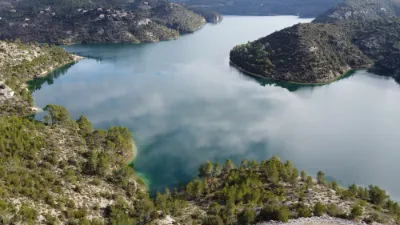
Gréoux les Bains, the Verdon

No reviews yet
Have you flown here? Share your experience with other pilots.
+ Write the first reviewDescription
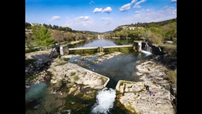
The Verdon (Verdoun in Provençal Occitan, Mistralian standard) is a French river that rises at the foot of the Tête de la Sestrière, between the Col d'Allos and the Pic des Trois-Évêchés, and flows into the Durance, near Vinon-sur-Verdon, after running 166.5 kilometers1.
Hydronymy The name Verdon (Virdones, Viridionis around 10304), called Vardu by the Gauls, comes from the pre-Celtic term vara, used to denote water5.
Geography In its upper course, the Verdon looks like a mountain torrent and has a steep gradient: at Saint-André-les-Alpes, 45 kilometers from its source, the river is already at 900 meters of altitude. Downstream from this point, gradually swelled by its tributaries, the Verdon crosses several mountain ridges through imposing gorges, the Verdon gorges, several of which have been fitted with hydroelectric dams.
Sources of the Verdon The Verdon rises in the Southern Alps, in the Provence-Alpes-Côte d'Azur region (Alpes-de-Haute-Provence department).
The Verdon is born from the confluence of three torrents:
the Verdon de la Foux, born on the Trois-Évêchés mountain; the Bouchier torrent, born on the Mont Pelat massif; the Chadoulin, outflow of Lake Allos. Municipalities crossed In the three departments of Alpes-de-Haute-Provence, Bouches-du-Rhône and Var, the Verdon crosses thirty-two municipalities.
Main towns along the river The Verdon flows mostly through the Alpes-de-Haute-Provence department; however, along several stretches it serves as the border between this department and the Var; the very last kilometers are in the Var. The confluence with the Durance is in the Bouches-du-Rhône near Cadarache.
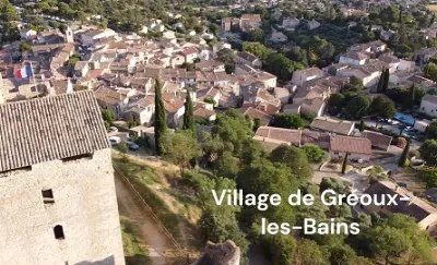
Allos, Colmars, Saint-André-les-Alpes, Castellane, Les Salles-sur-Verdon, Aiguines and Sainte-Croix-du-Verdon via Lake Sainte-Croix, Quinson, Esparron-de-Verdon, Gréoux-les-Bains, Vinon-sur-Verdon (Var), and in the immediate vicinity: Moustiers-Sainte-Marie. Place names The Verdon gave its hydronym to the following municipalities: Les Salles-sur-Verdon, Sainte-Croix-du-Verdon, Esparron-de-Verdon, Vinon-sur-Verdon, Artignosc-sur-Verdon, Saint-Laurent-du-Verdon, La Palud-sur-Verdon and Baudinard-sur-Verdon.
Watershed Its watershed covers 2,218 km22 or 2,294 km21.
Managing body The managing body is the Parc naturel régional du Verdon, a mixed syndicate and the lead structure for the SAGE of the Verdon watershed7.
Tributaries Main tributaries (from upstream to downstream)
the Lance (left bank note 1), 12.5 km in the municipality of Colmars, with no tributary. the Issole (right bank), 28.7 km at Saint-André-les-Alpes the Jabron (left bank), 31.2 km at the Carejuan clue the Bau or Baou (right bank), at the entrance to the Grand Canyon the Artuby (left bank), 53.8 km at the Mescla the Colostre (right bank), 36.2 km shortly before Gréoux-les-Bains
Map and restricted areas
Open in the main mapNearby aerodromes
Open aerodromes within 25 km of the spot, heliports included, with their distance and direction from the spot. Near an aerodrome, drone flying is prohibited or height-limited: check the UAS zones map.
| Aerodrome | Type | Distance | Elevation | Difference |
|---|---|---|---|---|
| Aérodrome de Vinon | Aerodrome | 8.1 km W | 275 m | spot 24 m higher |
Aviation weather (METAR and TAF)
No METAR station within 50 km.
Weather and Kp index
| Day | Weather | Temp. min. / max. | Wind | Rain | Max Kp |
|---|---|---|---|---|---|
| Sat 21 Nov | Fair | 3° / 15° | 16 km/h N | – | 2 |
| Sun 22 Nov | Clear sky | 8° / 14° | 30 km/h W | 8.3 mm | 2 |
| Mon 23 Nov | Partly cloudy | 4° / 12° | 33 km/h NW | – | 4 |
| Tue 24 Nov | Cloudy | 2° / 13° | 11 km/h SE | 0.2 mm | 2 |
| Wed 25 Nov | Rain | 7° / 9° | 17 km/h E | 21 mm | – |
| Thu 26 Nov | Fair | 3° / 10° | 7 km/h NE | 4.2 mm | – |
| Fri 27 Nov | Fair | -0° / 10° | 7 km/h NE | – | – |
Hour by hour: Saturday 21 November
| Time | Weather | Temp. | Wind | Rain | Clouds | Kp |
|---|---|---|---|---|---|---|
| 08:00 | Partly cloudy | 3° | 13 km/h N | – | 84 % | 2 |
| 09:00 | Partly cloudy | 5° | 16 km/h N | – | 100 % | 2 |
| 10:00 | Partly cloudy | 8° | 13 km/h NW | – | 96 % | 2 |
| 11:00 | Partly cloudy | 11° | 13 km/h W | – | 58 % | 2 |
| 12:00 | Fair | 13° | 12 km/h W | – | 32 % | 2 |
| 13:00 | Fair | 14° | 11 km/h W | – | 26 % | 1 |
| 14:00 | Fair | 15° | 12 km/h W | – | 15 % | 1 |
| 15:00 | Partly cloudy | 14° | 14 km/h SW | – | 41 % | 1 |
| 16:00 | Partly cloudy | 13° | 14 km/h W | – | 59 % | 2 |
| 17:00 | Partly cloudy | 10° | 10 km/h SW | – | 56 % | 2 |
| 18:00 | Partly cloudy | 8° | 7 km/h SW | – | 58 % | 2 |
| 19:00 | Partly cloudy | 8° | 5 km/h E | – | 70 % | 2 |
| 20:00 | Partly cloudy | 7° | 4 km/h E | – | 94 % | 2 |
| 21:00 | Cloudy | 6° | 5 km/h NE | – | 89 % | 2 |
| 22:00 | Cloudy | 5° | 7 km/h E | – | 100 % | 2 |
Hour by hour: Sunday 22 November
| Time | Weather | Temp. | Wind | Rain | Clouds | Kp |
|---|---|---|---|---|---|---|
| 06:00 | Rain | 11° | 21 km/h SE | 0.5 mm | 100 % | 2 |
| 07:00 | Rain | 12° | 21 km/h SE | 0.9 mm | 100 % | 2 |
| 08:00 | Heavy rain | 11° | 21 km/h SE | 3.1 mm | 100 % | 2 |
| 09:00 | Light rain | 11° | 16 km/h S | 0.3 mm | 99 % | 2 |
| 10:00 | Partly cloudy | 12° | 24 km/h SW | – | 83 % | 2 |
| 11:00 | Cloudy | 13° | 23 km/h W | – | 91 % | 2 |
| 12:00 | Cloudy | 12° | 22 km/h W | – | 87 % | 2 |
| 13:00 | Clear sky | 13° | 26 km/h W | – | 5 % | 2 |
| 14:00 | Clear sky | 14° | 29 km/h W | – | 8 % | 2 |
| 15:00 | Fair | 14° | 30 km/h W | – | 13 % | 2 |
| 16:00 | Clear sky | 12° | 27 km/h W | – | 7 % | 2 |
| 17:00 | Fair | 11° | 23 km/h W | – | 16 % | 2 |
| 18:00 | Fair | 10° | 22 km/h W | – | 17 % | 2 |
| 19:00 | Clear sky | 9° | 21 km/h W | – | 6 % | 2 |
| 20:00 | Fair | 9° | 23 km/h W | – | 14 % | 2 |
| 21:00 | Fair | 9° | 24 km/h W | – | 16 % | 2 |
| 22:00 | Fair | 8° | 23 km/h W | – | 34 % | 2 |
Sunrise and sunset
| Day | Dawn | Sunrise | Golden hour | Sunset | Dusk | Day length |
|---|---|---|---|---|---|---|
| Sat 21 Nov | 07:07 | 07:38 | 07:38–08:23 · 16:22–17:06 | 17:06 | 17:38 | 9 h 27 |
| Sun 22 Nov | 07:08 | 07:40 | 07:40–08:24 · 16:21–17:06 | 17:06 | 17:37 | 9 h 25 |
| Mon 23 Nov | 07:09 | 07:41 | 07:41–08:26 · 16:20–17:05 | 17:05 | 17:36 | 9 h 23 |
| Tue 24 Nov | 07:11 | 07:42 | 07:42–08:27 · 16:19–17:04 | 17:04 | 17:36 | 9 h 22 |
| Wed 25 Nov | 07:12 | 07:43 | 07:43–08:28 · 16:19–17:04 | 17:04 | 17:35 | 9 h 20 |
| Thu 26 Nov | 07:13 | 07:45 | 07:45–08:30 · 16:18–17:03 | 17:03 | 17:35 | 9 h 18 |
| Fri 27 Nov | 07:14 | 07:46 | 07:46–08:31 · 16:17–17:02 | 17:02 | 17:34 | 9 h 16 |

Reviews
Log in to review this spot. Log in · Create a free account
No reviews yet. Share yours!