

Le Thoureil

No reviews yet
Have you flown here? Share your experience with other pilots.
+ Write the first reviewDescription
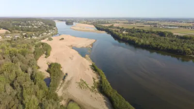
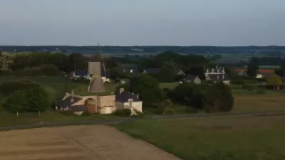
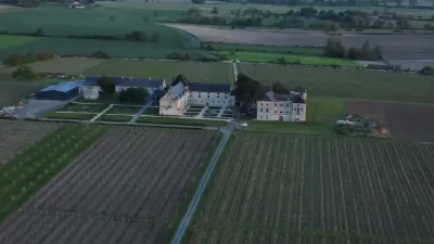
Emblematic of the Loire Valley, the old port of Le Thoureil recalls the golden age of river boating. The old mariners' houses string out their tuffeau stone façades and form a picturesque silhouette at the foot of the hillside. The village stretches out in a long line of dwellings along the Loire.
Until the 19th century, the history of this place was tied to various river activities: transport and trade, water crossings, ferry mills, fishing, control and tolls... River boating and the wine trade experienced their "golden age" in Le Thoureil in the 17th and 18th centuries.
Today many traces remain of this period when the Loire was a trading river: small mariners' dwellings, a merchant's "trading post", an ornamental tower, terraced gardens.
- - - - - - - - - - - - - - - - - - - - - - - - - - - - - - - - - - - - - - - - - - - - - - - - - - - - - - - - - - - - - - - - - - - - - - - - - - - - - Spot : @47.3690925,-0.270796 Wiki : https://fr.wikipedia.org/wiki/Le_Thoureil Gear: Dji Mini 3 Pro . Music: La Parisien - Jakub Pietras (Artlist.io)
Map and restricted areas
Open in the main mapNearby aerodromes
Open aerodromes within 25 km of the spot, heliports included, with their distance and direction from the spot. Near an aerodrome, drone flying is prohibited or height-limited: check the UAS zones map.
| Aerodrome | Type | Distance | Elevation | Difference |
|---|---|---|---|---|
| Aérodrome de Saumur - Saint-Florent | Aerodrome | 16 km SE | 82 m | spot 60 m lower |
| Centre Hospitalier Heliport | Heliport | 20 km SE | 83 m | spot 61 m lower |
| Cizay-la-Madeleine UL | Aerodrome | 22 km S | 44 m | spot 22 m lower |
| Angers-Loire Airport | Airport | 22 km N | 59 m | spot 37 m lower |
Aviation weather (METAR and TAF)
LFJR – Angers-Loire Airport LIFR
METAR
METAR LFJR 210800Z AUTO 12003KT 090V150 0800 0650 R26/1300U FG OVC003 09/09 Q1018
- Wind
- 120°, 6 km/h
- Visibility
- 800 m
- Weather
- Fog
- Clouds
- Overcast (8/8) at 300 ft (90 m)
- Temperature
- 9 °C, dew point 9 °C
- QNH
- 1018 hPa
- Flight category
- LIFR: ceiling < 500 ft or visibility < 1 mi
TAF
Weather and Kp index
| Day | Weather | Temp. min. / max. | Wind | Rain | Max Kp |
|---|---|---|---|---|---|
| Sat 21 Nov | Cloudy | 7° / 13° | 19 km/h SE | 3.2 mm | 2 |
| Sun 22 Nov | Partly cloudy | 10° / 14° | 32 km/h W | 18 mm | 2 |
| Mon 23 Nov | Fair | 6° / 12° | 25 km/h W | – | 4 |
| Tue 24 Nov | Cloudy | 1° / 6° | 14 km/h E | – | 2 |
| Wed 25 Nov | Cloudy | 4° / 6° | 15 km/h E | 2.0 mm | – |
| Thu 26 Nov | Clear sky | 1° / 4° | 14 km/h NE | – | – |
| Fri 27 Nov | Rain | -1° / 9° | 22 km/h S | 5.1 mm | – |
Hour by hour: Saturday 21 November
| Time | Weather | Temp. | Wind | Rain | Clouds | Kp |
|---|---|---|---|---|---|---|
| 09:00 | Fog | 7° | 8 km/h SE | – | 98 % | 2 |
| 10:00 | Fog | 8° | 9 km/h SE | – | 100 % | 2 |
| 11:00 | Fog | 10° | 10 km/h SE | – | 100 % | 2 |
| 12:00 | Fog | 11° | 13 km/h SE | – | 100 % | 2 |
| 13:00 | Cloudy | 12° | 14 km/h SE | – | 100 % | 1 |
| 14:00 | Cloudy | 12° | 15 km/h SE | – | 100 % | 1 |
| 15:00 | Cloudy | 13° | 16 km/h SE | – | 100 % | 1 |
| 16:00 | Cloudy | 13° | 17 km/h SE | – | 100 % | 2 |
| 17:00 | Cloudy | 12° | 14 km/h SE | – | 100 % | 2 |
| 18:00 | Cloudy | 11° | 14 km/h E | – | 100 % | 2 |
| 19:00 | Cloudy | 11° | 16 km/h SE | – | 100 % | 2 |
| 20:00 | Light rain | 11° | 17 km/h SE | 0.2 mm | 100 % | 2 |
| 21:00 | Rain | 11° | 19 km/h SE | 0.9 mm | 100 % | 2 |
| 22:00 | Heavy rain | 11° | 18 km/h SE | 1.0 mm | 100 % | 2 |
Hour by hour: Sunday 22 November
| Time | Weather | Temp. | Wind | Rain | Clouds | Kp |
|---|---|---|---|---|---|---|
| 06:00 | Heavy rain | 11° | 14 km/h S | 1.6 mm | 100 % | 2 |
| 07:00 | Rain | 11° | 20 km/h SW | 0.8 mm | 100 % | 2 |
| 08:00 | Light rain | 12° | 22 km/h SW | 0.3 mm | 100 % | 2 |
| 09:00 | Light rain | 11° | 23 km/h W | 0.2 mm | 100 % | 2 |
| 10:00 | Light rain | 11° | 30 km/h W | 0.1 mm | 100 % | 2 |
| 11:00 | Cloudy | 12° | 31 km/h W | – | 100 % | 2 |
| 12:00 | Cloudy | 13° | 31 km/h W | – | 100 % | 2 |
| 13:00 | Partly cloudy | 13° | 31 km/h W | – | 100 % | 2 |
| 14:00 | Rain | 14° | 32 km/h W | 0.7 mm | 100 % | 2 |
| 15:00 | Light rain | 11° | 28 km/h W | 0.1 mm | 100 % | 2 |
| 16:00 | Cloudy | 12° | 28 km/h W | – | 100 % | 2 |
| 17:00 | Cloudy | 12° | 27 km/h W | – | 100 % | 2 |
| 18:00 | Partly cloudy | 11° | 25 km/h W | – | 100 % | 2 |
| 19:00 | Partly cloudy | 11° | 25 km/h W | – | 96 % | 2 |
| 20:00 | Partly cloudy | 11° | 25 km/h W | – | 93 % | 2 |
| 21:00 | Partly cloudy | 10° | 25 km/h W | – | 89 % | 2 |
| 22:00 | Partly cloudy | 10° | 25 km/h W | – | 44 % | 2 |
Sunrise and sunset
| Day | Dawn | Sunrise | Golden hour | Sunset | Dusk | Day length |
|---|---|---|---|---|---|---|
| Sat 21 Nov | 07:40 | 08:14 | 08:14–09:03 · 16:31–17:20 | 17:20 | 17:54 | 9 h 05 |
| Sun 22 Nov | 07:42 | 08:16 | 08:16–09:04 · 16:30–17:19 | 17:19 | 17:53 | 9 h 03 |
| Mon 23 Nov | 07:43 | 08:17 | 08:17–09:06 · 16:29–17:18 | 17:18 | 17:52 | 9 h 01 |
| Tue 24 Nov | 07:44 | 08:18 | 08:18–09:08 · 16:28–17:17 | 17:17 | 17:51 | 8 h 58 |
| Wed 25 Nov | 07:45 | 08:20 | 08:20–09:09 · 16:27–17:16 | 17:16 | 17:51 | 8 h 56 |
| Thu 26 Nov | 07:47 | 08:21 | 08:21–09:11 · 16:26–17:16 | 17:16 | 17:50 | 8 h 54 |
| Fri 27 Nov | 07:48 | 08:22 | 08:22–09:12 · 16:25–17:15 | 17:15 | 17:50 | 8 h 52 |

Reviews
Log in to review this spot. Log in · Create a free account
No reviews yet. Share yours!