

Le Port de Châtillon

No reviews yet
Have you flown here? Share your experience with other pilots.
+ Write the first reviewDescription
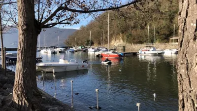
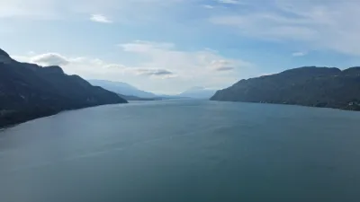
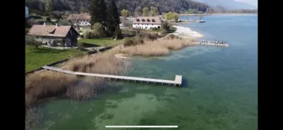
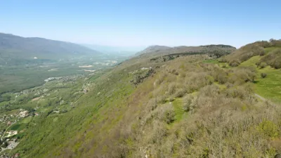
Castles, along with other elements of Savoy's thousand-year-old heritage, are one of the reflections of the department's great history. These buildings are a reminder that Savoie has always aroused a great deal of covetousness. If there is one site that visitors to Chautagne particularly appreciate, it is Châtillon, if only for its harbor and its pebble beach, ideal for enjoying Lac du Bourget in peace, but also for its castle, which is a must-see.
The oldest castle in Chindrieux Built on a Roman oppidum, Châtillon is the oldest castle in Chindrieux. In Roman times, the prefect of the fleet of the Upper Rhône boatmen was based on the site where the castle now stands, a strategic position that made it possible to control one of the most important communication routes in southeastern Gaul.
Although it was built starting in the 13th century, it seems that its imposing square tower already existed in the 11th century. As proof of the political importance of the local lordship, Lac du Bourget was then called Lac de Châtillon, like the castle and the hamlet of the same name.
Historic monument since 1991 It belonged successively to the Montluel, the Seyssel d'Aix, the Rambert and then the barons d'Anglejean-Chatillon, who still own it. Listed as a "Monument historique" since 1991, the castle is not open to the public, except for the gardens during the summer season.
Map and restricted areas
Open in the main mapNearby aerodromes
Open aerodromes within 25 km of the spot, heliports included, with their distance and direction from the spot. Near an aerodrome, drone flying is prohibited or height-limited: check the UAS zones map.
| Aerodrome | Type | Distance | Elevation | Difference |
|---|---|---|---|---|
| Base Hydro-ULM Rhône Lavours | Seaplane base | 5.0 km W | 239 m | spot 7 m lower |
| Lavours | Aerodrome | 5.4 km W | 234 m | same altitude as the spot |
| Grand Colombier Heliport | Heliport | 11 km NW | 1,437 m | spot 1,206 m lower |
| Hôtel Ariana Heliport | Heliport | 15 km S | 247 m | spot 15 m lower |
| Belley - Peyrieu Airfield | Aerodrome | 16 km SW | 225 m | spot 6 m higher |
Aviation weather (METAR and TAF)
LFLB – Chambéry-Savoie Airport VFR
METAR
METAR LFLB 210730Z AUTO VRB03KT 9999 BKN050 BKN066 OVC086 09/08 Q1021 NOSIG
- Wind
- Variable, 6 km/h
- Visibility
- 10 km or more
- Clouds
- Broken (5-7/8) at 5,000 ft (1520 m) ; Broken (5-7/8) at 6,600 ft (2010 m) ; Overcast (8/8) at 8,600 ft (2620 m)
- Temperature
- 9 °C, dew point 8 °C
- QNH
- 1021 hPa
- Flight category
- VFR: ceiling > 3,000 ft and visibility > 5 mi
TAF
TAF LFLB 210200Z 2103/2203 17008KT 9999 BKN050 PROB40 TEMPO 2103/2106 4000 -SHRA SCT040TCU BKN050 TEMPO 2200/2203 4000 RA
| Period (local time) | Change | Wind | Visibility | Weather | Clouds |
|---|---|---|---|---|---|
| 21/11 04:00 → 22/11 04:00 | Initial conditions | 170°, 15 km/h | 10 km or more | Broken (5-7/8) at 5,000 ft (1520 m) | |
| 21/11 04:00 → 21/11 07:00 | Temporarily, probability 40% | 4.0 km | Showers of rain light | Scattered (3-4/8) at 4,000 ft (1220 m) (towering cumulus) ; Broken (5-7/8) at 5,000 ft (1520 m) | |
| 22/11 01:00 → 22/11 04:00 | Temporarily | 4.0 km | Rain |
Weather and Kp index
| Day | Weather | Temp. min. / max. | Wind | Rain | Max Kp |
|---|---|---|---|---|---|
| Sat 21 Nov | Partly cloudy | 8° / 14° | 8 km/h N | 0.3 mm | 2 |
| Sun 22 Nov | Heavy rain | 7° / 10° | 17 km/h S | 38 mm | 2 |
| Mon 23 Nov | Light rain | 7° / 8° | 13 km/h S | 14 mm | 4 |
| Tue 24 Nov | Cloudy | 2° / 7° | 10 km/h NE | 0.2 mm | 2 |
| Wed 25 Nov | Rain | 3° / 4° | 12 km/h NE | 13 mm | – |
| Thu 26 Nov | Cloudy | 2° / 6° | 7 km/h N | 2.3 mm | – |
| Fri 27 Nov | Fair | 1° / 6° | 4 km/h N | – | – |
Hour by hour: Saturday 21 November
| Time | Weather | Temp. | Wind | Rain | Clouds | Kp |
|---|---|---|---|---|---|---|
| 08:00 | Showers | 8° | 4 km/h S | 0.2 mm | 65 % | 2 |
| 09:00 | Showers | 9° | 4 km/h SE | 0.1 mm | 52 % | 2 |
| 10:00 | Partly cloudy | 10° | 3 km/h N | – | 62 % | 2 |
| 11:00 | Partly cloudy | 11° | 3 km/h SE | – | 49 % | 2 |
| 12:00 | Fair | 12° | 3 km/h NE | – | 25 % | 2 |
| 13:00 | Partly cloudy | 13° | 3 km/h N | – | 49 % | 1 |
| 14:00 | Fair | 14° | 5 km/h N | – | 28 % | 1 |
| 15:00 | Partly cloudy | 14° | 8 km/h N | – | 66 % | 1 |
| 16:00 | Partly cloudy | 12° | 6 km/h N | – | 59 % | 2 |
| 17:00 | Partly cloudy | 10° | 5 km/h N | – | 81 % | 2 |
| 18:00 | Partly cloudy | 9° | 4 km/h NE | – | 96 % | 2 |
| 19:00 | Partly cloudy | 9° | 4 km/h NE | – | 88 % | 2 |
| 20:00 | Partly cloudy | 8° | 4 km/h NE | – | 95 % | 2 |
| 21:00 | Partly cloudy | 8° | 4 km/h NE | – | 95 % | 2 |
| 22:00 | Cloudy | 8° | 3 km/h N | – | 95 % | 2 |
Hour by hour: Sunday 22 November
| Time | Weather | Temp. | Wind | Rain | Clouds | Kp |
|---|---|---|---|---|---|---|
| 06:00 | Heavy rain | 8° | 9 km/h NE | 2.5 mm | 100 % | 2 |
| 07:00 | Heavy rain | 8° | 9 km/h NE | 3.1 mm | 100 % | 2 |
| 08:00 | Heavy rain | 8° | 7 km/h N | 2.5 mm | 100 % | 2 |
| 09:00 | Heavy rain | 8° | 6 km/h N | 3.1 mm | 100 % | 2 |
| 10:00 | Heavy rain | 8° | 5 km/h N | 4.1 mm | 100 % | 2 |
| 11:00 | Heavy rain | 8° | 6 km/h S | 1.4 mm | 100 % | 2 |
| 12:00 | Rain | 9° | 9 km/h S | 0.6 mm | 100 % | 2 |
| 13:00 | Heavy rain | 10° | 12 km/h S | 1.8 mm | 99 % | 2 |
| 14:00 | Heavy rain | 10° | 11 km/h S | 1.3 mm | 100 % | 2 |
| 15:00 | Heavy rain | 10° | 14 km/h S | 2.0 mm | 100 % | 2 |
| 16:00 | Light rain | 10° | 17 km/h S | 0.4 mm | 100 % | 2 |
| 17:00 | Showers | 9° | 14 km/h S | 1.0 mm | 85 % | 2 |
| 18:00 | Showers | 8° | 13 km/h S | 0.5 mm | 85 % | 2 |
| 19:00 | Rain | 8° | 12 km/h S | 0.9 mm | 87 % | 2 |
| 20:00 | Heavy rain | 8° | 12 km/h S | 2.0 mm | 100 % | 2 |
| 21:00 | Heavy rain | 8° | 13 km/h S | 1.7 mm | 100 % | 2 |
| 22:00 | Heavy rain | 8° | 15 km/h S | 2.1 mm | 100 % | 2 |
Sunrise and sunset
| Day | Dawn | Sunrise | Golden hour | Sunset | Dusk | Day length |
|---|---|---|---|---|---|---|
| Sat 21 Nov | 07:12 | 07:45 | 07:45–08:31 · 16:14–17:00 | 17:00 | 17:33 | 9 h 15 |
| Sun 22 Nov | 07:13 | 07:46 | 07:46–08:33 · 16:13–16:59 | 16:59 | 17:32 | 9 h 13 |
| Mon 23 Nov | 07:14 | 07:47 | 07:47–08:34 · 16:12–16:59 | 16:59 | 17:32 | 9 h 11 |
| Tue 24 Nov | 07:16 | 07:49 | 07:49–08:36 · 16:11–16:58 | 16:58 | 17:31 | 9 h 09 |
| Wed 25 Nov | 07:17 | 07:50 | 07:50–08:37 · 16:10–16:57 | 16:57 | 17:30 | 9 h 07 |
| Thu 26 Nov | 07:18 | 07:51 | 07:51–08:39 · 16:09–16:57 | 16:57 | 17:30 | 9 h 05 |
| Fri 27 Nov | 07:19 | 07:52 | 07:52–08:40 · 16:08–16:56 | 16:56 | 17:29 | 9 h 03 |

Reviews
Log in to review this spot. Log in · Create a free account
No reviews yet. Share yours!