

La cascade du Pissieu

No reviews yet
Have you flown here? Share your experience with other pilots.
+ Write the first reviewDescription
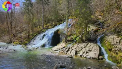
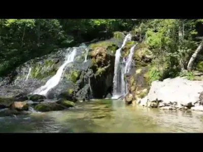
The Pissieu waterfall forms just downstream of a spring that drains most of the rain and snowmelt from the Margeriaz Plateau. It is a karst resurgence that works on the principle of a so-called "Vaucluse spring". Behind the entrance of the spring, a flooded underground network plunges to a depth of 50 meters and then rises back toward the Margeriaz plateau. 79 km of underground networks are now known beneath the Margeriaz plateau, including the Tanne du Cochon network, which has a vertical drop of 825 meters between its entrance on the plateau and the Pissieu resurgence.
Access via the parking area at the bridge over the Nant d'Aillon on the road linking Attilly to Villaret Rouge, from the Châtelard lake, or the parking area at the Base de loisirs des Iles du Chéran. Accessible year-round, the site is particularly spectacular after heavy rain or during the snowmelt.
Allow about 2 hours round trip from the leisure center.
Map and restricted areas
Open in the main mapNearby aerodromes
Open aerodromes within 25 km of the spot, heliports included, with their distance and direction from the spot. Near an aerodrome, drone flying is prohibited or height-limited: check the UAS zones map.
| Aerodrome | Type | Distance | Elevation | Difference |
|---|---|---|---|---|
| La Fullie | Heliport | 5.2 km SE | 1,394 m | spot 721 m lower |
| Hôtel Ariana Heliport | Heliport | 15 km W | 247 m | spot 426 m higher |
| Aérodrome de Chambéry Challes-les-Eaux | Aerodrome | 16 km SW | 297 m | spot 377 m higher |
| Chambéry-Savoie Airport | Airport | 18 km W | 237 m | spot 436 m higher |
| Albertville Airfield | Aerodrome | 18 km E | 315 m | spot 358 m higher |
Aviation weather (METAR and TAF)
LFLB – Chambéry-Savoie Airport VFR
METAR
METAR LFLB 210630Z AUTO 22004KT 180V260 9999 FEW048 OVC056 09/08 Q1020 NOSIG
- Wind
- 220°, 7 km/h
- Visibility
- 10 km or more
- Clouds
- Few (1-2/8) at 4,800 ft (1460 m) ; Overcast (8/8) at 5,600 ft (1710 m)
- Temperature
- 9 °C, dew point 8 °C
- QNH
- 1020 hPa
- Flight category
- VFR: ceiling > 3,000 ft and visibility > 5 mi
TAF
TAF LFLB 210200Z 2103/2203 17008KT 9999 BKN050 PROB40 TEMPO 2103/2106 4000 -SHRA SCT040TCU BKN050 TEMPO 2200/2203 4000 RA
| Period (local time) | Change | Wind | Visibility | Weather | Clouds |
|---|---|---|---|---|---|
| 21/11 04:00 → 22/11 04:00 | Initial conditions | 170°, 15 km/h | 10 km or more | Broken (5-7/8) at 5,000 ft (1520 m) | |
| 21/11 04:00 → 21/11 07:00 | Temporarily, probability 40% | 4.0 km | Showers of rain light | Scattered (3-4/8) at 4,000 ft (1220 m) (towering cumulus) ; Broken (5-7/8) at 5,000 ft (1520 m) | |
| 22/11 01:00 → 22/11 04:00 | Temporarily | 4.0 km | Rain |
Weather and Kp index
Sunrise and sunset
| Day | Dawn | Sunrise | Golden hour | Sunset | Dusk | Day length |
|---|---|---|---|---|---|---|
| Sat 21 Nov | 07:11 | 07:43 | 07:43–08:30 · 16:13–17:00 | 17:00 | 17:32 | 9 h 16 |
| Sun 22 Nov | 07:12 | 07:45 | 07:45–08:31 · 16:12–16:59 | 16:59 | 17:32 | 9 h 14 |
| Mon 23 Nov | 07:13 | 07:46 | 07:46–08:33 · 16:11–16:58 | 16:58 | 17:31 | 9 h 12 |
| Tue 24 Nov | 07:14 | 07:47 | 07:47–08:34 · 16:10–16:57 | 16:57 | 17:30 | 9 h 10 |
| Wed 25 Nov | 07:15 | 07:48 | 07:48–08:36 · 16:09–16:57 | 16:57 | 17:30 | 9 h 08 |
| Thu 26 Nov | 07:17 | 07:50 | 07:50–08:37 · 16:09–16:56 | 16:56 | 17:29 | 9 h 06 |
| Fri 27 Nov | 07:18 | 07:51 | 07:51–08:39 · 16:08–16:55 | 16:55 | 17:29 | 9 h 04 |


Reviews
Log in to review this spot. Log in · Create a free account
No reviews yet. Share yours!