Skip to content
Mountain

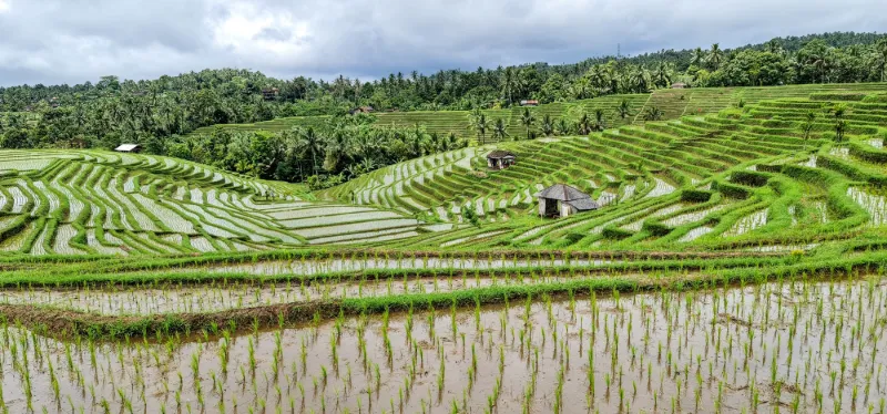
belimbing rice terrace

Indonesia

Check the zones and local rules before you fly.

We have no zone data for this country: ask the local authority before flying.

belimbing rice terrace – photo 1

No reviews yet

Have you flown here? Share your experience with other pilots.

+ Write the first review

Description

https://photos.app.goo.gl/YWqjmvQFS7BAT5Ws8

Automatic translation.

Map and restricted areas

Open in the main map

Aviation weather (METAR and TAF)

WADY · 39 km W VFR

METAR

Observed 21/11 15:00 · 18 min ago

METAR WADY 210700Z 13006KT 110V170 9999 SCT018 31/26 Q1012 NOSIG

Wind
130°, 11 km/h
Visibility
10 km or more
Clouds
Scattered (3-4/8) at 1,800 ft (550 m)
Temperature
31 °C, dew point 26 °C
QNH
1012 hPa
Flight category
VFR: ceiling > 3,000 ft and visibility > 5 mi

TAF

Issued 21/11 13:00 · valid from 21/11 14:00 to 22/11 14:00

TAF WADY 210500Z 2106/2206 16009KT 8000 SCT018 TEMPO 2108/2111 4000 TSRA FEW017CB BKN018

Period (local time) Change Wind Visibility Weather Clouds
21/11 14:00 → 22/11 14:00 Initial conditions 160°, 17 km/h 8 km Scattered (3-4/8) at 1,800 ft (550 m)
21/11 16:00 → 21/11 19:00 Temporarily 4.0 km Thunderstorm rain Few (1-2/8) at 1,700 ft (520 m) (cumulonimbus) ; Broken (5-7/8) at 1,800 ft (550 m)

Empty cell: no change forecast for that element.

METAR and TAF from NOAA (Aviation Weather Center), for guidance only: they do not replace flight planning with official sources (SIA, Météo-France). Nearest station that issues a METAR, not necessarily the nearest aerodrome.

Plan the light

Weather and Kp index

Loading forecast…

Sunrise and sunset

Local times at the spot (UTC+08:00). The golden hour, the warm, low light sought after for photos and videos, runs from sunrise until the sun reaches 6° above the horizon, and in the evening from 6° until sunset.

Day Dawn Sunrise Golden hour Sunset Dusk Day length
Sat 21 Nov05:29 05:51 05:51–06:21 · 17:53–18:23 18:23 18:4512 h 31
Sun 22 Nov05:29 05:51 05:51–06:21 · 17:54–18:23 18:23 18:4512 h 31
Mon 23 Nov05:29 05:51 05:51–06:21 · 17:54–18:24 18:24 18:4612 h 32
Tue 24 Nov05:29 05:52 05:52–06:21 · 17:54–18:24 18:24 18:4612 h 32
Wed 25 Nov05:29 05:52 05:52–06:21 · 17:55–18:24 18:24 18:4712 h 32
Thu 26 Nov05:30 05:52 05:52–06:22 · 17:55–18:25 18:25 18:4712 h 32
Fri 27 Nov05:30 05:52 05:52–06:22 · 17:56–18:25 18:25 18:4812 h 33

Nearby on Wikipedia

  • Kabupaten de Jembrana · 2.8 km away

    Le kabupaten de Jembrana, en indonésien , est un kabupaten d'Indonésie dans la province de Bali. Son chef-lieu est Negara. (...)

  • Mont Merbuk · 9.5 km away

    Le mont Merbuk, en indonésien ', est un volcan d'Indonésie situé dans l'ouest de l'île de Bali, culminant à d'altitude. Sa dernière éruption remonterait au Pléistocène. (...)

  • Pura (temple) · 14 km away

    Pura signifie « temple » en balinais. Le terme est employé pour désigner les temples hindouistes en Indonésie, et plus particulièrement à Bali où ils sont nombreux "". Bali Directory, consulté le 18 sept 2014.. Il existe trois types fondamentaux de temple dans chaque village : * Pura Puseh (temple (...)

  • Mont Patas · 14 km away

    Le mont Patas, en indonésien ', est un volcan d'Indonésie situé dans l'ouest de l'île de Bali, culminant à d'altitude. Sa dernière éruption remonterait au Pléistocène. (...)

Articles found by GeoNames from the spot's position.

Nearby spots

Reviews

Log in to review this spot. Log in · Create a free account

No reviews yet. Share yours!

Connection to the site lost. Trying again…

The site is not responding. Trying again in seconds.

The site is no longer responding.

The site has been updated. Reloading the page…

This page has expired.

Resuming failed. Please reload the page.

The site is no longer responding.