

Tartonne
No reviews yet
Have you flown here? Share your experience with other pilots.
+ Write the first reviewDescription
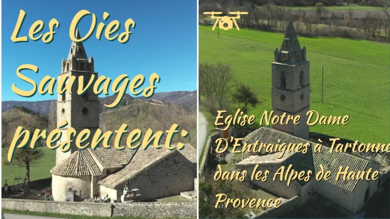
The church of Notre Dame d’Entraigues takes its name from the Latin inter aquas (between the waters), because of its position between the Asse and the Salaou torrent.
Based on their morphology and sculpted decoration, the nave and the choir appear to have been built in the 13th century. The bell tower, a faithful version of the Alpine model whose prototype is the bell tower of Embrun cathedral, bears the date 1564 but was only completed in 1621 by the Digne masons Jean Roubaud and Pierre Lavigne. The side chapels were built in the 17th century. The vault of the nave was partially rebuilt in 1830 and the bell tower was raised by one storey between 1863 and 1865. In 1891 and 1892 a major campaign of works took place: the original roof of lauzes (stone slabs) was replaced with a hollow-tile roof on a timber frame, the small nave formed by the two south side chapels was demolished, and the partition that isolated a small sacristy at the back of the apse was removed. In 1931, the bell tower, cracked by lightning, was again the subject of restoration work. Carried out by Etienne Arniaud, a contractor in Digne, the work consisted of demolishing and then rebuilding identically the upper part of the spire and the pinnacles. The chief architect J.-P. Ehrmann led another restoration campaign in 1976.
Map and restricted areas
Open in the main mapNearby aerodromes
Open aerodromes within 25 km of the spot, heliports included, with their distance and direction from the spot. Near an aerodrome, drone flying is prohibited or height-limited: check the UAS zones map.
| Aerodrome | Type | Distance | Elevation | Difference |
|---|---|---|---|---|
| Altisurface de Thorame--Haute Les Serres (2) | Aerodrome | 13 km NE | 1,950 m | spot 1,008 m lower |
| Altisurface de Thorame--Haute Les Serres | Aerodrome | 15 km NE | 1,868 m | spot 926 m lower |
| Altisurface de Thorame--Haute Chamatte | Aerodrome | 15 km NE | 2,081 m | spot 1,139 m lower |
| Col de Lèques | Aerodrome | 23 km S | 1,126 m | spot 184 m lower |
Aviation weather (METAR and TAF)
No METAR station within 50 km.
Weather and Kp index
Sunrise and sunset
| Day | Dawn | Sunrise | Golden hour | Sunset | Dusk | Day length |
|---|---|---|---|---|---|---|
| Sat 21 Nov | 07:06 | 07:37 | 07:37–08:22 · 16:19–17:03 | 17:03 | 17:35 | 9 h 26 |
| Sun 22 Nov | 07:07 | 07:39 | 07:39–08:23 · 16:18–17:03 | 17:03 | 17:34 | 9 h 24 |
| Mon 23 Nov | 07:08 | 07:40 | 07:40–08:25 · 16:17–17:02 | 17:02 | 17:34 | 9 h 22 |
| Tue 24 Nov | 07:09 | 07:41 | 07:41–08:26 · 16:16–17:01 | 17:01 | 17:33 | 9 h 20 |
| Wed 25 Nov | 07:10 | 07:42 | 07:42–08:28 · 16:15–17:01 | 17:01 | 17:32 | 9 h 18 |
| Thu 26 Nov | 07:11 | 07:43 | 07:43–08:29 · 16:14–17:00 | 17:00 | 17:32 | 9 h 16 |
| Fri 27 Nov | 07:13 | 07:45 | 07:45–08:30 · 16:14–16:59 | 16:59 | 17:31 | 9 h 14 |
Reviews
Log in to review this spot. Log in · Create a free account
No reviews yet. Share yours!