

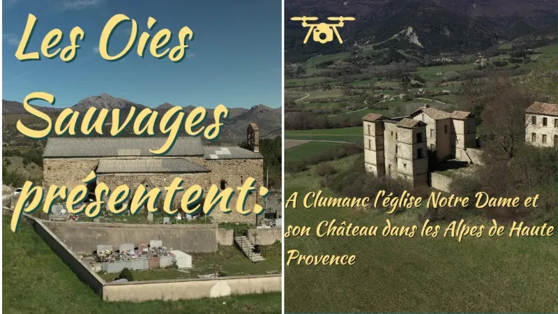
Clumanc, its church and its castle
No reviews yet
Have you flown here? Share your experience with other pilots.
+ Write the first reviewDescription
First mentioned only in the 14th century, the church of Notre-Dame was probably founded at the same time as the fortified village of Clumanc, in the 11th century at the latest. But the nave and apse that can be seen today can hardly have been built before the 14th century. In the 16th century, the west façade was reworked, as shown by the moulding of the door. The two side chapels, north and south, must have been built around the middle of the 16th century. This dating is based on the style of the coats of arms of the d'Oraison family, lords of Clumanc, carved on the keystones of the ribbed vaults, and on an indication given by the pastoral visit of 1717 concerning the establishment of the chaplaincies. The first south side chapel, with the neighboring sacristy, was built between 1693 and 1697, and the first north side chapel probably in the preceding decades. In 1840, the wall of the chevet was rebuilt, and in 1861 the painted decoration was completed or restored. The fitting out of the sacristy at the back of the apse is placed between these two dates. The asbestos-cement roof and framework, set on a raised section of concrete walls, replaced the old covering of sandstone lauze slabs, laid directly on the extrados of the vaults, toward the end of the 1970s. The church of Notre-Dame has always been surrounded by a cemetery. But its confinement to the south and east sides dates only from the 19th century. Previously it extended rather to the west and north. Clumanc does, however, have an old castle, half in ruins, enthroned on a height at the end of a tiny road climbing a hillside: the "château des Périer, a perfect example of the small pleasure châteaux built in Haute Provence at the beginning of the 17th century." Recognizable by its 4 square towers, perched on the medieval motte of Clumanc", with mullioned windows and 4 rows of génoises, in the Renaissance spirit, it is said to have been built after 1616, when the Périer family succeeded the Oraisons as Lords of the Clumanc valley", as an information panel will tell you. Today the castle still looks fine, its 4 towers are still standing, partly restored, but it is private property and cannot be visited.
Map and restricted areas
Open in the main mapNearby aerodromes
Open aerodromes within 25 km of the spot, heliports included, with their distance and direction from the spot. Near an aerodrome, drone flying is prohibited or height-limited: check the UAS zones map.
| Aerodrome | Type | Distance | Elevation | Difference |
|---|---|---|---|---|
| Altisurface de Thorame--Haute Les Serres (2) | Aerodrome | 15 km NE | 1,950 m | spot 1,030 m lower |
| Altisurface de Thorame--Haute Les Serres | Aerodrome | 17 km NE | 1,868 m | spot 948 m lower |
| Altisurface de Thorame--Haute Chamatte | Aerodrome | 18 km NE | 2,081 m | spot 1,160 m lower |
| Col de Lèques | Aerodrome | 19 km S | 1,126 m | spot 205 m lower |
Aviation weather (METAR and TAF)
No METAR station within 50 km.
Weather and Kp index
Sunrise and sunset
| Day | Dawn | Sunrise | Golden hour | Sunset | Dusk | Day length |
|---|---|---|---|---|---|---|
| Sat 21 Nov | 07:06 | 07:37 | 07:37–08:22 · 16:19–17:03 | 17:03 | 17:35 | 9 h 26 |
| Sun 22 Nov | 07:07 | 07:38 | 07:38–08:23 · 16:18–17:03 | 17:03 | 17:34 | 9 h 24 |
| Mon 23 Nov | 07:08 | 07:40 | 07:40–08:25 · 16:17–17:02 | 17:02 | 17:34 | 9 h 22 |
| Tue 24 Nov | 07:09 | 07:41 | 07:41–08:26 · 16:16–17:01 | 17:01 | 17:33 | 9 h 20 |
| Wed 25 Nov | 07:10 | 07:42 | 07:42–08:27 · 16:15–17:01 | 17:01 | 17:33 | 9 h 18 |
| Thu 26 Nov | 07:11 | 07:43 | 07:43–08:29 · 16:15–17:00 | 17:00 | 17:32 | 9 h 16 |
| Fri 27 Nov | 07:13 | 07:45 | 07:45–08:30 · 16:14–17:00 | 17:00 | 17:32 | 9 h 15 |

Reviews
Log in to review this spot. Log in · Create a free account
No reviews yet. Share yours!