

Île de Bréhat

No reviews yet
Have you flown here? Share your experience with other pilots.
+ Write the first reviewDescription
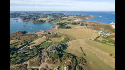
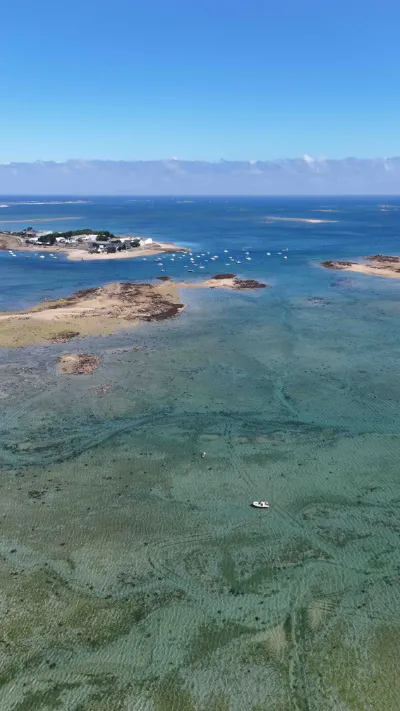
Just a narrow arm of the sea, a ten-minute boat ride from the pointe de l’Arcouest in Ploubazlanec to Bréhat, and you find yourself in another dimension. Here, time stands still! Mild climate, colors, landscapes… let yourself be enchanted by the magic of the island of flowers. Discover Bréhat Forget the car. There are no motor vehicles here; you get around only by bike or on foot. It's an ideal pace for exploring the island along any of its five hiking trails. Small in size (3.5 km long, 1.5 km wide), Bréhat is full of surprises. With its two islands linked by the Vauban bridge, going from south to north is already a journey in itself. In the south, you'll find the port, the beach, and the village with its lively square, its proud privateers' houses and its 16th-century church. In the north, purple moorland and stone walls have a hint of Ireland about them. Give yourself a day, preferably off-season and away from the summer crowds, to discover all its secrets.
Map and restricted areas
Open in the main mapNearby aerodromes
Open aerodromes within 25 km of the spot, heliports included, with their distance and direction from the spot. Near an aerodrome, drone flying is prohibited or height-limited: check the UAS zones map.
| Aerodrome | Type | Distance | Elevation |
|---|---|---|---|
| Base ULM de Kerfot | Aerodrome | 16 km S | 99 m |
Aviation weather (METAR and TAF)
LFRO – Lannion-Côte de Granit Airport VFR
METAR
METAR LFRO 210700Z AUTO 14007KT CAVOK 05/05 Q1015
- Wind
- 140°, 13 km/h
- Visibility
- 10 km or more
- Clouds
- –
- Temperature
- 5 °C, dew point 5 °C
- QNH
- 1015 hPa
- Flight category
- VFR: ceiling > 3,000 ft and visibility > 5 mi
TAF
Weather and Kp index
| Day | Weather | Temp. min. / max. | Wind | Rain | Max Kp |
|---|---|---|---|---|---|
| Sat 21 Nov | Cloudy | 8° / 13° | 45 km/h SE | 4.7 mm | 2 |
| Sun 22 Nov | Heavy rain | 12° / 13° | 63 km/h W | 12 mm | 2 |
| Mon 23 Nov | Partly cloudy | 11° / 13° | 47 km/h NW | 0.8 mm | 4 |
| Tue 24 Nov | Partly cloudy | 8° / 12° | 29 km/h SE | – | 2 |
| Wed 25 Nov | Cloudy | 8° / 9° | 37 km/h NE | 2.2 mm | – |
| Thu 26 Nov | Cloudy | 6° / 8° | 30 km/h E | – | – |
| Fri 27 Nov | Cloudy | 5° / 11° | 35 km/h SE | 7.5 mm | – |
Hour by hour: Saturday 21 November
| Time | Weather | Temp. | Wind | Rain | Clouds | Kp |
|---|---|---|---|---|---|---|
| 08:00 | Fog | 8° | 14 km/h S | – | 99 % | 2 |
| 09:00 | Fog | 9° | 15 km/h S | – | 100 % | 2 |
| 10:00 | Fog | 9° | 18 km/h SE | – | 100 % | 2 |
| 11:00 | Fog | 10° | 22 km/h SE | – | 100 % | 2 |
| 12:00 | Fog | 10° | 25 km/h SE | – | 100 % | 2 |
| 13:00 | Cloudy | 11° | 26 km/h SE | – | 100 % | 1 |
| 14:00 | Cloudy | 12° | 28 km/h SE | – | 100 % | 1 |
| 15:00 | Cloudy | 12° | 30 km/h SE | – | 100 % | 1 |
| 16:00 | Cloudy | 12° | 33 km/h SE | – | 100 % | 2 |
| 17:00 | Partly cloudy | 13° | 35 km/h SE | – | 60 % | 2 |
| 18:00 | Partly cloudy | 13° | 38 km/h SE | – | 78 % | 2 |
| 19:00 | Cloudy | 12° | 41 km/h SE | – | 100 % | 2 |
| 20:00 | Cloudy | 12° | 42 km/h SE | – | 100 % | 2 |
| 21:00 | Rain | 12° | 44 km/h SE | 0.7 mm | 100 % | 2 |
| 22:00 | Heavy rain | 12° | 45 km/h SE | 2.4 mm | 100 % | 2 |
Hour by hour: Sunday 22 November
| Time | Weather | Temp. | Wind | Rain | Clouds | Kp |
|---|---|---|---|---|---|---|
| 06:00 | Heavy rain | 13° | 18 km/h SW | 2.0 mm | 100 % | 2 |
| 07:00 | Rain | 13° | 33 km/h SW | 0.6 mm | 100 % | 2 |
| 08:00 | Light rain | 13° | 37 km/h W | 0.3 mm | 100 % | 2 |
| 09:00 | Rain | 13° | 41 km/h W | 0.8 mm | 100 % | 2 |
| 10:00 | Heavy rain | 13° | 50 km/h W | 1.5 mm | 100 % | 2 |
| 11:00 | Heavy rain | 13° | 60 km/h W | 1.1 mm | 100 % | 2 |
| 12:00 | Rain | 13° | 58 km/h W | 0.9 mm | 100 % | 2 |
| 13:00 | Heavy rain | 12° | 58 km/h W | 1.0 mm | 100 % | 2 |
| 14:00 | Cloudy | 13° | 63 km/h W | – | 100 % | 2 |
| 15:00 | Cloudy | 13° | 63 km/h W | – | 100 % | 2 |
| 16:00 | Light rain | 13° | 62 km/h W | 0.1 mm | 100 % | 2 |
| 17:00 | Cloudy | 13° | 60 km/h W | – | 100 % | 2 |
| 18:00 | Cloudy | 13° | 59 km/h W | – | 100 % | 2 |
| 19:00 | Cloudy | 13° | 58 km/h W | – | 100 % | 2 |
| 20:00 | Cloudy | 13° | 55 km/h NW | – | 100 % | 2 |
| 21:00 | Cloudy | 13° | 52 km/h NW | – | 100 % | 2 |
| 22:00 | Cloudy | 13° | 51 km/h NW | – | 100 % | 2 |
Sunrise and sunset
| Day | Dawn | Sunrise | Golden hour | Sunset | Dusk | Day length |
|---|---|---|---|---|---|---|
| Sat 21 Nov | 07:55 | 08:30 | 08:30–09:21 · 16:35–17:26 | 17:26 | 18:01 | 8 h 55 |
| Sun 22 Nov | 07:56 | 08:32 | 08:32–09:23 · 16:33–17:25 | 17:25 | 18:00 | 8 h 52 |
| Mon 23 Nov | 07:58 | 08:33 | 08:33–09:25 · 16:32–17:24 | 17:24 | 17:59 | 8 h 50 |
| Tue 24 Nov | 07:59 | 08:35 | 08:35–09:26 · 16:31–17:23 | 17:23 | 17:58 | 8 h 48 |
| Wed 25 Nov | 08:00 | 08:36 | 08:36–09:28 · 16:30–17:22 | 17:22 | 17:58 | 8 h 46 |
| Thu 26 Nov | 08:02 | 08:37 | 08:37–09:29 · 16:29–17:21 | 17:21 | 17:57 | 8 h 43 |
| Fri 27 Nov | 08:03 | 08:39 | 08:39–09:31 · 16:28–17:20 | 17:20 | 17:56 | 8 h 41 |




Reviews
Log in to review this spot. Log in · Create a free account
No reviews yet. Share yours!