

Agua Amarga (Nijar) Spain Mining Terminal
No reviews yet
Have you flown here? Share your experience with other pilots.
+ Write the first reviewDescription
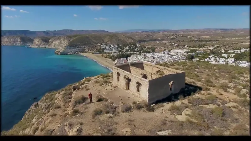
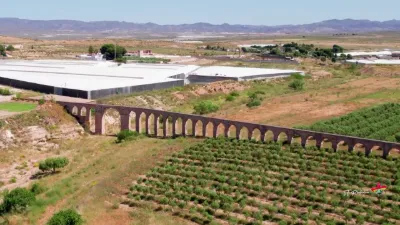
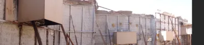
The "Mining Terminal" of Agua Amarga refers to the remains of the mining industry known as the "antiguo cargadero de mineral".
This is where ships were loaded with iron ore from Lucainena de las Torres.
The name Agua Amarga, which means "bitter water", dates from a time when trains brought minerals from the mines of the Sierra Alhamilla mountains to the town.
The chemicals used in the mining process contaminated the local water wells, making the water unfit to drink.
On the eastern hill overlooking the town, you can explore the ruins and enjoy the stunning view over Agua Amarga and the coastline.
The picturesque whitewashed village of Agua Amarga has about 400 inhabitants and a calm sandy beach with clear turquoise waters.
The railway line linking the mines of the village of Lucainena de las Torres, in the Sierra Alhamilla mountains, to the coast at Agua Amarga was used to carry the ore to the coast for shipping.
A consortium, the Sierra Alhamilla Mining Company (CMSA), was created to exploit the mineral deposits.
The mines were 30 km from the sea, and a railway was needed because of the terrain.
___________________________________________________________________________________________________
The "Mining Terminal" of Agua Amarga refers to the remains of the mining industry known as the "antiguo cargadero de mineral".
Ships were loaded here with iron ore from Lucainena de las Torres.
The name Agua Amarga, which means "bitter water", comes from a time when trains brought minerals from the mines of the Sierra Alhamilla to the town.
The chemicals used in the mining process contaminated the local water wells, making the water undrinkable.
On the eastern hill overlooking the town, you can explore the ruins and enjoy the impressive views of Agua Amarga and the coast.
The picturesque whitewashed village of Agua Amarga has about 400 inhabitants and a quiet sandy beach with clear turquoise waters.
The railway line connecting the mines of the village of Lucainena de las Torres, in the Sierra Alhamilla, with the coast at Agua Amarga was used to carry ore to the coast for shipping.
A consortium, the Sierra Alhamilla Mining Company (CMSA), was created to exploit the mineral deposits.
The mines were 30 km from the sea and, because of the terrain, a railway was necessary.
Map and restricted areas
Open in the main mapAviation weather (METAR and TAF)
LEAM – Almería Airport VFR
METAR
METAR LEAM 211100Z 20003KT CAVOK 18/13 Q1021
- Wind
- 200°, 6 km/h
- Visibility
- 10 km or more
- Clouds
- –
- Temperature
- 18 °C, dew point 13 °C
- QNH
- 1021 hPa
- Flight category
- VFR: ceiling > 3,000 ft and visibility > 5 mi
TAF
TAF LEAM 210500Z 2106/2206 VRB03KT CAVOK TX21/2114Z TN15/2106Z BECMG 2120/2122 24012KT
| Period (local time) | Change | Wind | Visibility | Weather | Clouds |
|---|---|---|---|---|---|
| 21/11 07:00 → 21/11 21:00 | Initial conditions | Variable, 6 km/h | 10 km or more | No significant cloud | |
| 21/11 21:00 → 22/11 07:00 | Becoming | 240°, 22 km/h | 10 km or more | No significant cloud |
Weather and Kp index
Sunrise and sunset
| Day | Dawn | Sunrise | Golden hour | Sunset | Dusk | Day length |
|---|---|---|---|---|---|---|
| Sat 21 Nov | 07:24 | 07:52 | 07:52–08:31 · 17:16–17:55 | 17:55 | 18:23 | 10 h 02 |
| Sun 22 Nov | 07:25 | 07:53 | 07:53–08:32 · 17:16–17:54 | 17:54 | 18:22 | 10 h 01 |
| Mon 23 Nov | 07:26 | 07:54 | 07:54–08:33 · 17:15–17:54 | 17:54 | 18:22 | 9 h 59 |
| Tue 24 Nov | 07:27 | 07:55 | 07:55–08:34 · 17:14–17:53 | 17:53 | 18:22 | 9 h 58 |
| Wed 25 Nov | 07:28 | 07:56 | 07:56–08:35 · 17:14–17:53 | 17:53 | 18:21 | 9 h 56 |
| Thu 26 Nov | 07:29 | 07:57 | 07:57–08:37 · 17:13–17:53 | 17:53 | 18:21 | 9 h 55 |
| Fri 27 Nov | 07:30 | 07:58 | 07:58–08:38 · 17:13–17:52 | 17:52 | 18:21 | 9 h 54 |

Reviews
Log in to review this spot. Log in · Create a free account
No reviews yet. Share yours!