

Jonquière St Vincent, the Chapelle St Laurent

No reviews yet
Have you flown here? Share your experience with other pilots.
+ Write the first reviewDescription
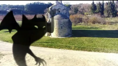
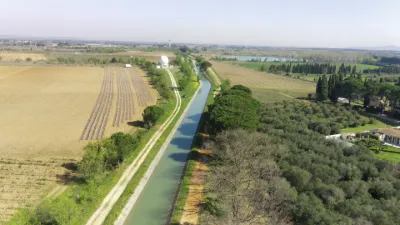
A pretty Romanesque church, the Chapelle Saint-Laurent in Jonquières-Saint-Vincent is a listed Historic Monument. In spring, it is surrounded by a field of poppies!
This very beautiful Romanesque chapel, built at the end of the 11th century, has undergone many alterations and restorations.
Located beside the road linking Beaucaire and Nîmes, it is one of the most unusual Romanesque sanctuaries in the lower Rhône valley. The chapel is the last remnant of the hamlet of Saint-Laurent, which has since disappeared.
With a very simple plan, the chapel has a single nave completed by a semicircular apse. A fire in 1636 destroyed two of the three original bays.
Inside, you can see two Roman milestones dating from the emperor Claudius supporting the triumphal arch of the choir. Visits are possible on request for groups.
Map and restricted areas
Open in the main mapNearby aerodromes
Open aerodromes within 25 km of the spot, heliports included, with their distance and direction from the spot. Near an aerodrome, drone flying is prohibited or height-limited: check the UAS zones map.
| Aerodrome | Type | Distance | Elevation | Difference |
|---|---|---|---|---|
| Nîmes Courbessac Airport | Aerodrome | 13 km W | 60 m | spot 41 m lower |
| Nîmes-Arles-Camargue Airport | Airport | 15 km SW | 94 m | spot 76 m lower |
| Centre Hospitalier Heliport | Heliport | 20 km NE | 21 m | same altitude as the spot |
| Aérodrome d'Avignon-Pujaut | Aerodrome | 23 km NE | 45 m | spot 26 m lower |
Aviation weather (METAR and TAF)
LFTW – Nîmes-Arles-Camargue Airport VFR
METAR
METAR LFTW 210630Z AUTO 02003KT CAVOK 07/06 Q1020 NOSIG
- Wind
- 020°, 6 km/h
- Visibility
- 10 km or more
- Clouds
- –
- Temperature
- 7 °C, dew point 6 °C
- QNH
- 1020 hPa
- Flight category
- VFR: ceiling > 3,000 ft and visibility > 5 mi
TAF
TAF LFTW 210200Z 2103/2203 VRB03KT CAVOK BECMG 2119/2121 13010KT -RA BKN020 PROB40 TEMPO 2122/2203 13015G25KT 4000 RA BKN012 BKN025
| Period (local time) | Change | Wind | Visibility | Weather | Clouds |
|---|---|---|---|---|---|
| 21/11 04:00 → 21/11 20:00 | Initial conditions | Variable, 6 km/h | 10 km or more | No significant weather | No significant cloud |
| 21/11 20:00 → 22/11 04:00 | Becoming | 130°, 19 km/h | 10 km or more | Rain light | Broken (5-7/8) at 2,000 ft (610 m) |
| 21/11 23:00 → 22/11 04:00 | Temporarily, probability 40% | 130°, 28 km/h, gusts 46 km/h | 4.0 km | Rain | Broken (5-7/8) at 1,200 ft (370 m) ; Broken (5-7/8) at 2,500 ft (760 m) |
Weather and Kp index
Sunrise and sunset
| Day | Dawn | Sunrise | Golden hour | Sunset | Dusk | Day length |
|---|---|---|---|---|---|---|
| Sat 21 Nov | 07:12 | 07:44 | 07:44–08:28 · 16:27–17:11 | 17:11 | 17:43 | 9 h 27 |
| Sun 22 Nov | 07:14 | 07:45 | 07:45–08:30 · 16:26–17:10 | 17:10 | 17:42 | 9 h 25 |
| Mon 23 Nov | 07:15 | 07:46 | 07:46–08:31 · 16:25–17:10 | 17:10 | 17:41 | 9 h 23 |
| Tue 24 Nov | 07:16 | 07:48 | 07:48–08:33 · 16:24–17:09 | 17:09 | 17:41 | 9 h 21 |
| Wed 25 Nov | 07:17 | 07:49 | 07:49–08:34 · 16:23–17:09 | 17:09 | 17:40 | 9 h 19 |
| Thu 26 Nov | 07:18 | 07:50 | 07:50–08:35 · 16:23–17:08 | 17:08 | 17:40 | 9 h 17 |
| Fri 27 Nov | 07:19 | 07:51 | 07:51–08:37 · 16:22–17:07 | 17:07 | 17:39 | 9 h 16 |

Reviews
Log in to review this spot. Log in · Create a free account
No reviews yet. Share yours!