

Walzin Castle
No reviews yet
Have you flown here? Share your experience with other pilots.
+ Write the first reviewDescription
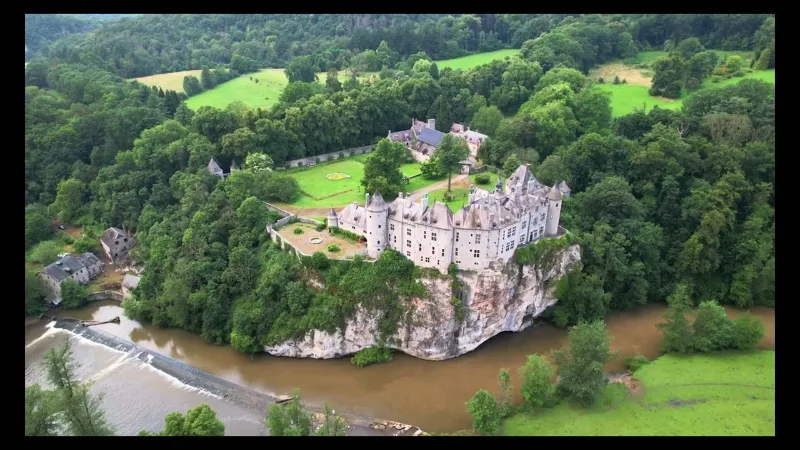
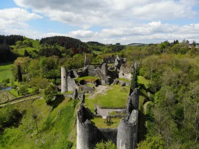
Walzin Castle follows the contours of an impressive rocky cliff, naturally defended on three sides, at the foot of which a meander of the Lesse winds.
The wild beauty of the site and the density of the buildings are impressive.
A first castle is thought to have been built after the destruction of the Cavrenne keep located a short distance away (around 1489 or 1554 at the latest), even though the lords and lands of Walzin are mentioned as early as the 13th century. In any case, the oldest parts of the castle (considerably altered in the 19th and 20th centuries) do not seem to predate the 15th-16th centuries. A massive D-shaped tower (dating from the 15th or early 16th century), ending the East wing, must be regarded as the site's "main tower." It was built in a single piece for artillery and was probably originally isolated; its walls are 2.50 m thick on the first level. Located in the South wing, the quadrangular keep probably dates back to the 16th century and is only a residential building.
"The enormous sheer rock on which Walzin is built suddenly rises up, overhanging the river, eroded by the water, rugged, cracked, riddled with holes like a sponge. The Lesse forms a deep chasm with a calm surface at the foot of this natural wall…"
Map and restricted areas
Open in the main mapAviation weather (METAR and TAF)
EBCI – Brussels South Charleroi Airport IFR
METAR
METAR EBCI 210650Z 21006KT 4000 BR NSC 01/01 Q1018 NOSIG
- Wind
- 210°, 11 km/h
- Visibility
- 4.0 km
- Weather
- Mist
- Clouds
- –
- Temperature
- 1 °C, dew point 1 °C
- QNH
- 1018 hPa
- Flight category
- IFR: ceiling 500–1,000 ft or visibility 1–3 mi
TAF
TAF EBCI 210500Z 2106/2212 20004KT 9999 FEW035 PROB30 2106/2108 2000 BR BKN003 PROB30 2203/2207 4000 BR
| Period (local time) | Change | Wind | Visibility | Weather | Clouds |
|---|---|---|---|---|---|
| 21/11 07:00 → 22/11 13:00 | Initial conditions | 200°, 7 km/h | 10 km or more | Few (1-2/8) at 3,500 ft (1070 m) | |
| 21/11 07:00 → 21/11 09:00 | probability 30% | 2.0 km | Mist | Broken (5-7/8) at 300 ft (90 m) | |
| 22/11 04:00 → 22/11 08:00 | probability 30% | 4.0 km | Mist |
Weather and Kp index
Sunrise and sunset
| Day | Dawn | Sunrise | Golden hour | Sunset | Dusk | Day length |
|---|---|---|---|---|---|---|
| Sat 21 Nov | 07:27 | 08:03 | 08:03–08:57 · 15:56–16:49 | 16:49 | 17:25 | 8 h 45 |
| Sun 22 Nov | 07:28 | 08:05 | 08:05–08:58 · 15:54–16:48 | 16:48 | 17:24 | 8 h 42 |
| Mon 23 Nov | 07:30 | 08:06 | 08:06–09:00 · 15:53–16:47 | 16:47 | 17:23 | 8 h 40 |
| Tue 24 Nov | 07:31 | 08:08 | 08:08–09:02 · 15:52–16:46 | 16:46 | 17:23 | 8 h 38 |
| Wed 25 Nov | 07:33 | 08:09 | 08:09–09:04 · 15:51–16:45 | 16:45 | 17:22 | 8 h 35 |
| Thu 26 Nov | 07:34 | 08:11 | 08:11–09:05 · 15:50–16:44 | 16:44 | 17:21 | 8 h 33 |
| Fri 27 Nov | 07:35 | 08:12 | 08:12–09:07 · 15:49–16:43 | 16:43 | 17:20 | 8 h 31 |
Reviews
Log in to review this spot. Log in · Create a free account
No reviews yet. Share yours!