

Chapelle Ste Philomène in Montmaure

No reviews yet
Have you flown here? Share your experience with other pilots.
+ Write the first reviewDescription
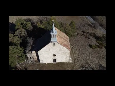
Built on a circular mound, it was probably the parish church until the 16th century (when the village church was built). In poor condition at the start of the 19th century, it was restored after the miracle of 1838 for pilgrimages. This restoration had the effect of reducing the Romanesque-style building, which had a Latin cross plan measuring 22.40 meters by 14.50 meters, by removing both arms of the transept, as well as part of the nave and the façade. Listed in the inventory of historic monuments, all that remains of this church is a single bay covered by a semicircular barrel vault. To the left of the façade and at the back of the building, the ruins of one of the former side chapels still remain. Finally, worth noting is the grave of Antoine Mauduis, a hero of the Resistance and companion of President Mitterand, in front of the main façade.
Map and restricted areas
Open in the main mapNearby aerodromes
Open aerodromes within 25 km of the spot, heliports included, with their distance and direction from the spot. Near an aerodrome, drone flying is prohibited or height-limited: check the UAS zones map.
| Aerodrome | Type | Distance | Elevation | Difference |
|---|---|---|---|---|
| Aérodrome d'Aspres-sur-Buëch | Aerodrome | 12 km SW | 831 m | spot 47 m higher |
| Altisurface de Saint-Étienne-en-Dévoluy | Aerodrome | 12 km N | 1,890 m | spot 1,012 m lower |
| Hôpital Heliport | Heliport | 16 km E | 759 m | spot 119 m higher |
| Serres - La Bâtie-Montsaléon Airfield | Aerodrome | 16 km SW | 715 m | spot 163 m higher |
| Gap - Tallard Airfield | Aerodrome | 17 km SE | 605 m | spot 273 m higher |
Aviation weather (METAR and TAF)
No METAR station within 50 km.
Weather and Kp index
Sunrise and sunset
| Day | Dawn | Sunrise | Golden hour | Sunset | Dusk | Day length |
|---|---|---|---|---|---|---|
| Sat 21 Nov | 07:09 | 07:41 | 07:41–08:26 · 16:19–17:04 | 17:04 | 17:36 | 9 h 23 |
| Sun 22 Nov | 07:10 | 07:42 | 07:42–08:28 · 16:18–17:03 | 17:03 | 17:35 | 9 h 21 |
| Mon 23 Nov | 07:11 | 07:43 | 07:43–08:29 · 16:17–17:02 | 17:02 | 17:34 | 9 h 19 |
| Tue 24 Nov | 07:12 | 07:45 | 07:45–08:30 · 16:16–17:02 | 17:02 | 17:34 | 9 h 17 |
| Wed 25 Nov | 07:14 | 07:46 | 07:46–08:32 · 16:15–17:01 | 17:01 | 17:33 | 9 h 15 |
| Thu 26 Nov | 07:15 | 07:47 | 07:47–08:33 · 16:14–17:01 | 17:01 | 17:33 | 9 h 13 |
| Fri 27 Nov | 07:16 | 07:48 | 07:48–08:34 · 16:14–17:00 | 17:00 | 17:32 | 9 h 11 |



Reviews
Log in to review this spot. Log in · Create a free account
No reviews yet. Share yours!