

Le Bono
No reviews yet
Have you flown here? Share your experience with other pilots.
+ Write the first reviewDescription
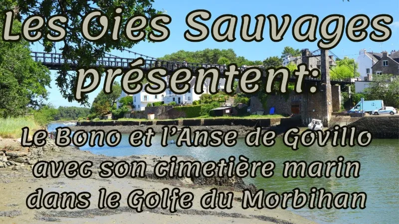
Le Bono is a peaceful little village of about 2,300 inhabitants that has managed to preserve its authenticity. This magnificent port near Auray is a real treat for those who love the picturesque. Le Bono once had significant activity, with around four hundred sailors and more than a hundred boats. From the old suspension bridge of Le Bono, built more than 150 years ago, you get a superb view of the port and the former oyster-farming yards. You will discover wild landscapes of rare beauty along the coastal paths of more than 8 km. What to see The Old Suspension Bridge linking Le Bono to the Pays d'Auray, an unmissable landmark of the town, completed in 1840. Several phases of work were needed to counter the damaging effects of time. Thanks to the generosity of many private individuals and patrons, and through a "Fondation du Patrimoine" subscription, the bridge has been completely renovated and reopened to pedestrians and cyclists. The boat graveyard The boat graveyard can be reached by turning right at the west end of the bridge and following the coastal path for a few hundred meters to a small cove. There are not many hulls still intact, but you find that very particular atmosphere of desolation typical of boat graveyards. For a photographer, this kind of place is an almost inexhaustible subject, because the views change with the tides, the light conditions and the shooting angles.
Map and restricted areas
Open in the main mapNearby aerodromes
Open aerodromes within 25 km of the spot, heliports included, with their distance and direction from the spot. Near an aerodrome, drone flying is prohibited or height-limited: check the UAS zones map.
| Aerodrome | Type | Distance | Elevation | Difference |
|---|---|---|---|---|
| Chubert Centre Hospitalier Heliport | Heliport | 16 km E | 10 m | spot 8 m higher |
| Vannes-Meucon Airport | Airport | 20 km NE | 136 m | spot 118 m lower |
| Quiberon Airport | Aerodrome | 21 km SW | 11 m | spot 7 m higher |
Aviation weather (METAR and TAF)
LFRV – Vannes-Meucon Airport LIFR
METAR
METAR LFRV 210630Z AUTO 10004KT 1000 BR VV/// 11/11 Q1016
- Wind
- 100°, 7 km/h
- Visibility
- 1,000 m
- Weather
- Mist
- Clouds
- –
- Temperature
- 11 °C, dew point 11 °C
- QNH
- 1016 hPa
- Flight category
- LIFR: ceiling < 500 ft or visibility < 1 mi
TAF
Weather and Kp index
| Day | Weather | Temp. min. / max. | Wind | Rain | Max Kp |
|---|---|---|---|---|---|
| Sat 21 Nov | Cloudy | 11° / 14° | 45 km/h SE | 8.6 mm | 2 |
| Sun 22 Nov | Showers | 12° / 14° | 62 km/h W | 9.9 mm | 2 |
| Mon 23 Nov | Partly cloudy | 10° / 13° | 44 km/h W | – | 4 |
| Tue 24 Nov | Clear sky | 7° / 9° | 22 km/h SE | – | 2 |
| Wed 25 Nov | Cloudy | 6° / 7° | 23 km/h NE | 15 mm | – |
| Thu 26 Nov | Partly cloudy | 2° / 5° | 17 km/h NE | – | – |
| Fri 27 Nov | Light rain | 5° / 13° | 24 km/h S | 15 mm | – |
Hour by hour: Saturday 21 November
| Time | Weather | Temp. | Wind | Rain | Clouds | Kp |
|---|---|---|---|---|---|---|
| 08:00 | Fog | 11° | 18 km/h SE | – | 99 % | 2 |
| 09:00 | Fog | 11° | 20 km/h SE | – | 100 % | 2 |
| 10:00 | Cloudy | 12° | 24 km/h SE | – | 100 % | 2 |
| 11:00 | Cloudy | 13° | 29 km/h SE | – | 100 % | 2 |
| 12:00 | Cloudy | 13° | 31 km/h SE | – | 98 % | 2 |
| 13:00 | Cloudy | 13° | 32 km/h SE | – | 92 % | 1 |
| 14:00 | Cloudy | 14° | 33 km/h SE | – | 100 % | 1 |
| 15:00 | Partly cloudy | 14° | 37 km/h SE | – | 99 % | 1 |
| 16:00 | Partly cloudy | 14° | 39 km/h SE | – | 100 % | 2 |
| 17:00 | Cloudy | 13° | 39 km/h SE | – | 100 % | 2 |
| 18:00 | Rain | 13° | 40 km/h SE | 0.5 mm | 100 % | 2 |
| 19:00 | Heavy rain | 13° | 42 km/h SE | 1.3 mm | 100 % | 2 |
| 20:00 | Heavy rain | 12° | 45 km/h SE | 1.5 mm | 100 % | 2 |
| 21:00 | Heavy rain | 12° | 44 km/h SE | 1.0 mm | 100 % | 2 |
| 22:00 | Rain | 12° | 41 km/h SE | 1.0 mm | 100 % | 2 |
Hour by hour: Sunday 22 November
| Time | Weather | Temp. | Wind | Rain | Clouds | Kp |
|---|---|---|---|---|---|---|
| 06:00 | Light rain | 13° | 48 km/h W | 0.2 mm | 100 % | 2 |
| 07:00 | Light rain | 12° | 54 km/h W | 0.1 mm | 100 % | 2 |
| 08:00 | Light rain | 12° | 62 km/h W | 0.2 mm | 94 % | 2 |
| 09:00 | Showers | 12° | 54 km/h W | 0.1 mm | 21 % | 2 |
| 10:00 | Showers | 13° | 53 km/h W | 0.1 mm | 22 % | 2 |
| 11:00 | Showers | 13° | 49 km/h W | 0.1 mm | 33 % | 2 |
| 12:00 | Showers | 13° | 50 km/h W | 0.2 mm | 56 % | 2 |
| 13:00 | Showers | 13° | 55 km/h W | 0.3 mm | 30 % | 2 |
| 14:00 | Fair | 13° | 53 km/h W | – | 21 % | 2 |
| 15:00 | Clear sky | 14° | 53 km/h W | – | 3 % | 2 |
| 16:00 | Fair | 13° | 57 km/h W | – | 14 % | 2 |
| 17:00 | Clear sky | 13° | 49 km/h W | – | 6 % | 2 |
| 18:00 | Clear sky | 12° | 48 km/h W | – | 12 % | 2 |
| 19:00 | Fair | 12° | 49 km/h W | – | 23 % | 2 |
| 20:00 | Clear sky | 12° | 47 km/h W | – | 6 % | 2 |
| 21:00 | Clear sky | 12° | 45 km/h W | – | 2 % | 2 |
| 22:00 | Clear sky | 12° | 44 km/h W | – | 3 % | 2 |
Sunrise and sunset
| Day | Dawn | Sunrise | Golden hour | Sunset | Dusk | Day length |
|---|---|---|---|---|---|---|
| Sat 21 Nov | 07:52 | 08:26 | 08:26–09:15 · 16:40–17:30 | 17:30 | 18:04 | 9 h 03 |
| Sun 22 Nov | 07:53 | 08:27 | 08:27–09:17 · 16:39–17:29 | 17:29 | 18:03 | 9 h 01 |
| Mon 23 Nov | 07:54 | 08:29 | 08:29–09:18 · 16:38–17:28 | 17:28 | 18:02 | 8 h 59 |
| Tue 24 Nov | 07:56 | 08:30 | 08:30–09:20 · 16:37–17:27 | 17:27 | 18:01 | 8 h 57 |
| Wed 25 Nov | 07:57 | 08:31 | 08:31–09:21 · 16:36–17:26 | 17:26 | 18:01 | 8 h 54 |
| Thu 26 Nov | 07:58 | 08:33 | 08:33–09:23 · 16:35–17:26 | 17:26 | 18:00 | 8 h 52 |
| Fri 27 Nov | 07:59 | 08:34 | 08:34–09:24 · 16:34–17:25 | 17:25 | 18:00 | 8 h 50 |




Reviews
Log in to review this spot. Log in · Create a free account
No reviews yet. Share yours!