

L'île aux Pies

No reviews yet
Have you flown here? Share your experience with other pilots.
+ Write the first reviewDescription
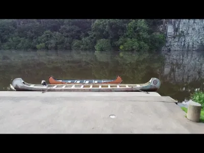
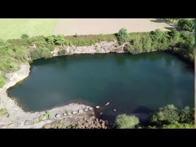
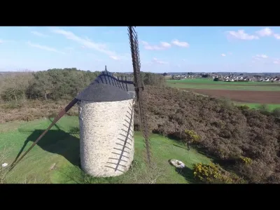
This Grand Site Naturel dotted with cliffs is impressive. Crossed by the Canal de Nantes à Brest and located about twenty minutes from Rochefort-en-Terre, the Île-aux-Pies can be reached on foot, by boat, by bike or by car. The natural promontories of the Île-aux-Pies call for the most beautiful breaks… and poses. Famous throughout Brittany, the climbing sites take advantage of the rocky slopes at Saint-Vincent-sur-Oust on the Morbihan side. If you're feeling sporty, the place is also great for hiking, horseback riding, cycling and canoe-kayaking. Here is a quick overview of the activities to enjoy at this exceptional site. Located in the Pays de Redon, both spectacular and peaceful, the Île-aux-Pies site offers walks and bike rides along the Oust, a river that winds majestically between granite cliffs. Access to the site from two opposite banks, Bains-sur-Oust (Ille-et-Vilaine) and Saint-Vincent-sur-Oust, allows you to multiply the hikes, in summer as in winter. On the marked trails, the scents of gorse, broom and cinereous heather remind you that you are in the heart of Brittany. The panorama that takes in the valley and its maritime pines makes a perfect picnic spot for a break. When summer comes, the Oust river offers a huge and varied playground. From the Île-aux-Pies, you can easily set off in a canoe-kayak, a pedal boat, a paddleboard… or a barge! More precisely, a Breton pénette, a small wooden boat with a characteristic shape that you can rent by the hour or by the day. Once on the water, you let yourself be lulled by the lapping of the water, listening to chaffinches, herons and blue tits. The Île-aux-Pies site is also known for its fishing quality. You can fish for carp and gudgeon there, from a boat or from the banks.
Facing the cliffs that plunge sheer into the water, leisure takes on a vertical dimension at the Île-aux-Pies. It is one of the most famous climbing sites in Brittany! The Parc Aventure lets everyone enjoy the thrills of verticality. Located on the Morbihan side in Saint-Vincent-sur-Oust, the park offers many activity courses including climbing, tree-top adventure, zip line and orienteering. It takes about two hours to complete all the courses, one of which is reserved for the little ones (ages 4 to 6). The orienteering course is also an excellent introduction to the wildlife, plants and history of the Île-aux-Pies. On the Ille-et-Vilaine side, in Bains-sur-Oust, a well-hidden treasure awaits those who solve the riddles! Discover this geocaching activity, ideal for children.
Map and restricted areas
Open in the main mapNearby aerodromes
Open aerodromes within 25 km of the spot, heliports included, with their distance and direction from the spot. Near an aerodrome, drone flying is prohibited or height-limited: check the UAS zones map.
| Aerodrome | Type | Distance | Elevation | Difference |
|---|---|---|---|---|
| Redon Bains-sur-Oust Airport | Aerodrome | 6.6 km E | 68 m | spot 64 m lower |
| Aérodrome privé Le Quilloux | Aerodrome | 20 km SE | 37 m | spot 33 m lower |
Aviation weather (METAR and TAF)
LFRZ – Saint-Nazaire-Montoir Airport LIFR
METAR
METAR LFRZ 210630Z AUTO 09005KT 0700 0650 R25/0800N FG VV/// 10/09 Q1016 TEMPO 0300 FG
- Wind
- 090°, 9 km/h
- Visibility
- 700 m
- Weather
- Fog
- Clouds
- –
- Temperature
- 10 °C, dew point 9 °C
- QNH
- 1016 hPa
- Flight category
- LIFR: ceiling < 500 ft or visibility < 1 mi
TAF
TAF AMD LFRZ 210602Z 2106/2206 13005KT 1500 BR OVC002 TEMPO 2106/2110 0300 FG VV/// BECMG 2110/2113 9999 NSW BKN006 BECMG 2113/2115 12015KT SCT014 BECMG 2117/2120 4500 -RA BKN014 TEMPO 2120/2201 2500 DZRA BKN006 OVC012 TEMPO 2201/2203 16015G30KT 2500 RA BKN004 BKN012 SCT025CB FM220300 25015G25KT 9999 SCT012 TEMPO 2203/2206 26020G35KT 3000 SHRA BKN020CB
| Period (local time) | Change | Wind | Visibility | Weather | Clouds |
|---|---|---|---|---|---|
| 21/11 07:00 → 21/11 11:00 | Initial conditions | 130°, 9 km/h | 1.5 km | Mist | Overcast (8/8) at 200 ft (60 m) |
| 21/11 07:00 → 21/11 11:00 | Temporarily | 300 m | Fog | ||
| 21/11 11:00 → 21/11 14:00 | Becoming | 130°, 9 km/h | 10 km or more | No significant weather | Broken (5-7/8) at 600 ft (180 m) |
| 21/11 14:00 → 21/11 18:00 | Becoming | 120°, 28 km/h | 10 km or more | No significant weather | Scattered (3-4/8) at 1,400 ft (430 m) |
| 21/11 18:00 → 22/11 04:00 | Becoming | 120°, 28 km/h | 4.5 km | Rain light | Broken (5-7/8) at 1,400 ft (430 m) |
| 21/11 21:00 → 22/11 02:00 | Temporarily | 2.5 km | Drizzle ; rain | Broken (5-7/8) at 600 ft (180 m) ; Overcast (8/8) at 1,200 ft (370 m) | |
| 22/11 02:00 → 22/11 04:00 | Temporarily | 160°, 28 km/h, gusts 56 km/h | 2.5 km | Rain | Broken (5-7/8) at 400 ft (120 m) ; Broken (5-7/8) at 1,200 ft (370 m) ; Scattered (3-4/8) at 2,500 ft (760 m) (cumulonimbus) |
| 22/11 04:00 → 22/11 07:00 | From | 250°, 28 km/h, gusts 46 km/h | 10 km or more | Scattered (3-4/8) at 1,200 ft (370 m) | |
| 22/11 04:00 → 22/11 07:00 | Temporarily | 260°, 37 km/h, gusts 65 km/h | 3.0 km | Showers of rain | Broken (5-7/8) at 2,000 ft (610 m) (cumulonimbus) |
Weather and Kp index
Sunrise and sunset
| Day | Dawn | Sunrise | Golden hour | Sunset | Dusk | Day length |
|---|---|---|---|---|---|---|
| Sat 21 Nov | 07:49 | 08:23 | 08:23–09:12 · 16:37–17:26 | 17:26 | 18:00 | 9 h 03 |
| Sun 22 Nov | 07:50 | 08:24 | 08:24–09:14 · 16:36–17:25 | 17:25 | 17:59 | 9 h 00 |
| Mon 23 Nov | 07:51 | 08:26 | 08:26–09:15 · 16:35–17:24 | 17:24 | 17:59 | 8 h 58 |
| Tue 24 Nov | 07:52 | 08:27 | 08:27–09:17 · 16:34–17:23 | 17:23 | 17:58 | 8 h 56 |
| Wed 25 Nov | 07:54 | 08:28 | 08:28–09:18 · 16:33–17:23 | 17:23 | 17:57 | 8 h 54 |
| Thu 26 Nov | 07:55 | 08:30 | 08:30–09:20 · 16:32–17:22 | 17:22 | 17:57 | 8 h 52 |
| Fri 27 Nov | 07:56 | 08:31 | 08:31–09:21 · 16:31–17:21 | 17:21 | 17:56 | 8 h 50 |

Reviews
Log in to review this spot. Log in · Create a free account
No reviews yet. Share yours!