

The Dames de Meuse (the Rocks)
No reviews yet
Have you flown here? Share your experience with other pilots.
+ Write the first reviewDescription
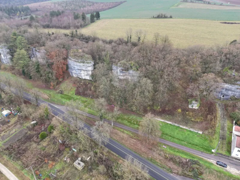
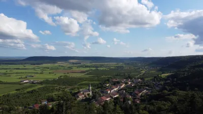
The Dames de Meuse, seven in number like the Seven Sisters of Norway, are a very popular walking spot for the people of Saint-Mihiel. The first, called the Roche du Calvaire, is the focus of an annual pilgrimage on the evening of Good Friday. A grotto was carved into the rock itself and shelters a Christ in the tomb, the work of a local artist named Mangeot. The second rock has no special name; halfway up, in a natural niche, a stone bench has been carved, called the Lovers' Bench. Next comes the Ronde Flaise (a local corruption of Ronde Falaise, "round cliff") because of its ample shapes, then the Roche Plate (very easy to access from the top). The fifth rock is cut by an enormous fault and is called the "Devil's Oven". The second-to-last (the last rock is on private property) is nicknamed the guinguette; people used to dance there, and the rock still bears traces of pre-war constructions. It was once topped by a sort of stone table sculpted by erosion, also called the Devil's Table. This table was shattered by a shell during the Great War. A symbol and curiosity of the town, these seven coral rocks are located at the edge of town in the direction of Verdun. The top of some of the rocks is accessible and offers an unbeatable view over the town.
Map and restricted areas
Open in the main mapNearby aerodromes
Open aerodromes within 25 km of the spot, heliports included, with their distance and direction from the spot. Near an aerodrome, drone flying is prohibited or height-limited: check the UAS zones map.
No known open aerodrome within 25 km.
Aviation weather (METAR and TAF)
LFSO – Nancy-Ochey (BA 133) Air Base MVFR
METAR
METAR LFSO 210930Z AUTO 10004KT 5000 BR SCT012 OVC018 06/06 Q1019
- Wind
- 100°, 7 km/h
- Visibility
- 5 km
- Weather
- Mist
- Clouds
- Scattered (3-4/8) at 1,200 ft (370 m) ; Overcast (8/8) at 1,800 ft (550 m)
- Temperature
- 6 °C, dew point 6 °C
- QNH
- 1019 hPa
- Flight category
- MVFR: ceiling 1,000–3,000 ft or visibility 3–5 mi
TAF
Weather and Kp index
Sunrise and sunset
| Day | Dawn | Sunrise | Golden hour | Sunset | Dusk | Day length |
|---|---|---|---|---|---|---|
| Sat 21 Nov | 07:21 | 07:56 | 07:56–08:47 · 16:00–16:51 | 16:51 | 17:26 | 8 h 55 |
| Sun 22 Nov | 07:22 | 07:58 | 07:58–08:49 · 15:59–16:50 | 16:50 | 17:26 | 8 h 52 |
| Mon 23 Nov | 07:24 | 07:59 | 07:59–08:50 · 15:58–16:49 | 16:49 | 17:25 | 8 h 50 |
| Tue 24 Nov | 07:25 | 08:00 | 08:00–08:52 · 15:57–16:49 | 16:49 | 17:24 | 8 h 48 |
| Wed 25 Nov | 07:26 | 08:02 | 08:02–08:54 · 15:56–16:48 | 16:48 | 17:23 | 8 h 45 |
| Thu 26 Nov | 07:28 | 08:03 | 08:03–08:55 · 15:55–16:47 | 16:47 | 17:23 | 8 h 43 |
| Fri 27 Nov | 07:29 | 08:05 | 08:05–08:57 · 15:54–16:46 | 16:46 | 17:22 | 8 h 41 |
Reviews
Log in to review this spot. Log in · Create a free account
No reviews yet. Share yours!