

Prieuré d'Alayrac

No reviews yet
Have you flown here? Share your experience with other pilots.
+ Write the first reviewDescription
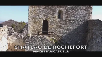
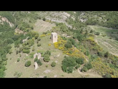
The Aleyrac priory is a Romanesque priory located in the commune of Aleyrac in the French département of Drôme and the Auvergne-Rhône-Alpes region. The priory, in ruins, is located southeast of Aleyrac, on departmental road 809 leading to Taulignan. The ruined priory church of Notre-Dame is all that remains of the Benedictine priory of Aleyrac, whose monastic buildings have completely disappeared1. This church is called "Notre-Dame-la-Brune", meaning "Notre-Dame-de-la-Source"2. Indeed, within the church grounds a captured spring flows, still accessible.
It has been listed as a historic monument since 13 November 19053. The priory church retains a façade pierced by an arched doorway topped by two arched windows with single splay, which are in turn topped by an arched window with double splay.
This façade, which could be described as a wall belfry, is crowned by a small bell turret with two bell openings.
Inside, the nave walls are punctuated by large relieving arches separated by flat pilasters.
The apse is decorated with a half-dome vault whose springing is pentagonal.
Map and restricted areas
Open in the main mapNearby aerodromes
Open aerodromes within 25 km of the spot, heliports included, with their distance and direction from the spot. Near an aerodrome, drone flying is prohibited or height-limited: check the UAS zones map.
| Aerodrome | Type | Distance | Elevation | Difference |
|---|---|---|---|---|
| Valréas Visan Airfield | Aerodrome | 18 km S | 144 m | spot 299 m higher |
| Aérodrome de Montélimar - Ancône | Aerodrome | 18 km NW | 73 m | spot 370 m higher |
| Aérodrome de Pierrelatte | Aerodrome | 21 km SW | 60 m | spot 383 m higher |
| Clinique Pneumologique des rieux Heliport | Heliport | 23 km SE | 315 m | spot 128 m higher |
Aviation weather (METAR and TAF)
LFMO – Orange-Caritat (BA 115) Air Base VFR
METAR
METAR LFMO 210630Z AUTO 36004KT 320V020 CAVOK 04/04 Q1020 NOSIG
- Wind
- 360°, 7 km/h
- Visibility
- 10 km or more
- Clouds
- –
- Temperature
- 4 °C, dew point 4 °C
- QNH
- 1020 hPa
- Flight category
- VFR: ceiling > 3,000 ft and visibility > 5 mi
TAF
TAF LFMO 210200Z 2103/2203 32003KT CAVOK TX16/2115Z TN05/2105Z PROB30 TEMPO 2122/2203 4000 -RA BECMG 2201/2203 13015G25KT
| Period (local time) | Change | Wind | Visibility | Weather | Clouds |
|---|---|---|---|---|---|
| 21/11 04:00 → 22/11 02:00 | Initial conditions | 320°, 6 km/h | 10 km or more | No significant cloud | |
| 21/11 23:00 → 22/11 04:00 | Temporarily, probability 30% | 4.0 km | Rain light | ||
| 22/11 02:00 → 22/11 04:00 | Becoming | 130°, 28 km/h, gusts 46 km/h | 10 km or more | No significant cloud |
Weather and Kp index
Sunrise and sunset
| Day | Dawn | Sunrise | Golden hour | Sunset | Dusk | Day length |
|---|---|---|---|---|---|---|
| Sat 21 Nov | 07:13 | 07:44 | 07:44–08:30 · 16:23–17:08 | 17:08 | 17:40 | 9 h 23 |
| Sun 22 Nov | 07:14 | 07:46 | 07:46–08:31 · 16:22–17:07 | 17:07 | 17:39 | 9 h 21 |
| Mon 23 Nov | 07:15 | 07:47 | 07:47–08:32 · 16:21–17:06 | 17:06 | 17:38 | 9 h 19 |
| Tue 24 Nov | 07:16 | 07:48 | 07:48–08:34 · 16:20–17:06 | 17:06 | 17:38 | 9 h 17 |
| Wed 25 Nov | 07:17 | 07:49 | 07:49–08:35 · 16:19–17:05 | 17:05 | 17:37 | 9 h 15 |
| Thu 26 Nov | 07:18 | 07:51 | 07:51–08:37 · 16:18–17:04 | 17:04 | 17:37 | 9 h 13 |
| Fri 27 Nov | 07:19 | 07:52 | 07:52–08:38 · 16:18–17:04 | 17:04 | 17:36 | 9 h 12 |




Reviews
Log in to review this spot. Log in · Create a free account
No reviews yet. Share yours!