

Chapelle Notre Dame de Lamanon

No reviews yet
Have you flown here? Share your experience with other pilots.
+ Write the first reviewDescription
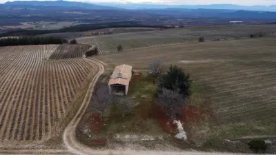
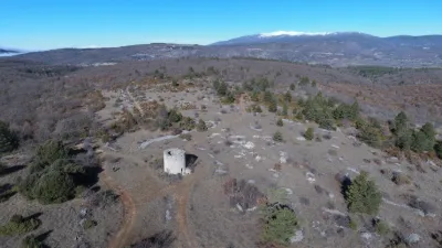
In Provence, chapels are often far from any housing. Sometimes this is because village centers have moved, but just as often these chapels have always stood in secluded places. This is also the case for the Chapelle Notre-Dame de Lamaron, set on a 1,090-meter high point of the Albion Plateau. The wind blows here almost constantly.
Lavender and clary sage are grown here, shining just as purple in the distance.
The chapel is recorded as a possession of the Saint-Victor Abbey of Marseille in 1032. The apse and a few decorative stones reused on the facades date from that time.
The nave dates from 1667, as indicated by a stone placed in the porch roof. visit duration 15 min chapel viewpoint In Provence, chapels are often far from any housing. Sometimes this is because village centers have moved, but just as often these chapels have always stood in secluded places. This is also the case for the Chapelle Notre-Dame de Lamaron, set on a 1,090-meter high point of the Albion Plateau. The wind blows here almost constantly.
Lavender and clary sage are grown here, shining just as purple in the distance.
History of the place The chapel is recorded as a possession of the Saint-Victor Abbey of Marseille in 1032. The apse and a few decorative stones reused on the facades date from that time.
The nave dates from 1667, as indicated by a stone placed in the porch roof.
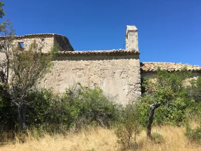
The chapel is built on a very simple plan. A nave with a round apse on the east side and a very large porch roof on the west.
The irregularly coursed cut stone is mostly covered with roughcast.
The single-opening bell gable stands between the porch roof and the nave.
A water cistern is thought to lie beneath the paving. There is no public transport serving the site.
Access by car We are on the Albion Plateau between Sault and Apt along the D34.
The fastest access is via Avignon and Apt when coming from the west, and Manosque and Apt when coming from the east.
Parking You can park at the start of the farm track that leads to the chapel.
Map and restricted areas
Open in the main mapNearby aerodromes
Open aerodromes within 25 km of the spot, heliports included, with their distance and direction from the spot. Near an aerodrome, drone flying is prohibited or height-limited: check the UAS zones map.
| Aerodrome | Type | Distance | Elevation | Difference |
|---|---|---|---|---|
| Altisurface de Banon | Aerodrome | 14 km NE | 1,135 m | spot 47 m lower |
| Saint Martin de Castillon | Aerodrome | 18 km S | 335 m | spot 753 m higher |
| Hôtel La Coquillade Heliport | Heliport | 19 km SW | 249 m | spot 839 m higher |
Aviation weather (METAR and TAF)
LFMV – Avignon-Caumont Airport VFR
METAR
METAR LFMV 210730Z AUTO 35002KT CAVOK 04/04 Q1021 NOSIG
- Wind
- 350°, 4 km/h
- Visibility
- 10 km or more
- Clouds
- –
- Temperature
- 4 °C, dew point 4 °C
- QNH
- 1021 hPa
- Flight category
- VFR: ceiling > 3,000 ft and visibility > 5 mi
TAF
TAF LFMV 210200Z 2103/2203 VRB03KT CAVOK BECMG 2119/2121 13010KT -RA BKN020 PROB40 TEMPO 2122/2203 13015G25KT 4000 RA BKN012 BKN025
| Period (local time) | Change | Wind | Visibility | Weather | Clouds |
|---|---|---|---|---|---|
| 21/11 04:00 → 21/11 20:00 | Initial conditions | Variable, 6 km/h | 10 km or more | No significant weather | No significant cloud |
| 21/11 20:00 → 22/11 04:00 | Becoming | 130°, 19 km/h | 10 km or more | Rain light | Broken (5-7/8) at 2,000 ft (610 m) |
| 21/11 23:00 → 22/11 04:00 | Temporarily, probability 40% | 130°, 28 km/h, gusts 46 km/h | 4.0 km | Rain | Broken (5-7/8) at 1,200 ft (370 m) ; Broken (5-7/8) at 2,500 ft (760 m) |
Weather and Kp index
Sunrise and sunset
| Day | Dawn | Sunrise | Golden hour | Sunset | Dusk | Day length |
|---|---|---|---|---|---|---|
| Sat 21 Nov | 07:09 | 07:41 | 07:41–08:25 · 16:22–17:07 | 17:07 | 17:39 | 9 h 26 |
| Sun 22 Nov | 07:10 | 07:42 | 07:42–08:27 · 16:22–17:06 | 17:06 | 17:38 | 9 h 24 |
| Mon 23 Nov | 07:12 | 07:43 | 07:43–08:28 · 16:21–17:06 | 17:06 | 17:37 | 9 h 22 |
| Tue 24 Nov | 07:13 | 07:44 | 07:44–08:30 · 16:20–17:05 | 17:05 | 17:37 | 9 h 20 |
| Wed 25 Nov | 07:14 | 07:46 | 07:46–08:31 · 16:19–17:04 | 17:04 | 17:36 | 9 h 18 |
| Thu 26 Nov | 07:15 | 07:47 | 07:47–08:32 · 16:18–17:04 | 17:04 | 17:36 | 9 h 16 |
| Fri 27 Nov | 07:16 | 07:48 | 07:48–08:34 · 16:18–17:03 | 17:03 | 17:35 | 9 h 15 |



Reviews
Log in to review this spot. Log in · Create a free account
No reviews yet. Share yours!