

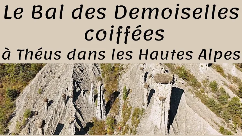
The Demoiselles Coiffées site of Théus
No reviews yet
Have you flown here? Share your experience with other pilots.
+ Write the first reviewDescription
A legend tells that in the village of Théus lived young ladies who loved to go wherever there was dancing.
One day, when a violinist came to visit, they organized a party in a small valley where the Vallauria stream flows. The party took place on Mardi Gras. They danced until their partners suggested stopping because the next day was the first day of Lent. But, stubborn and carried away by the music, they kept going until the last strokes of midnight. It was a bad move: they were condemned to an eternal waltz, petrified in the "Ballroom". Ever since, above the torrent, one finds these curious stone columns topped with a rock.
It is also said that when the stone falls, they will be freed from their sad fate as Capped Maidens!
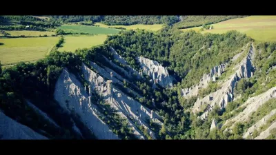
Geology Between Serre-Ponçon and Remollon, the Vallauria valley holds the largest concentration in France of Demoiselles Coiffées (or fairy chimneys).
The Demoiselles Coiffées of Théus emerge from a ruin-like landscape on the slopes of Mont Colombis, within soft ground deposited by glaciers. In these moraines the stones are not sorted, so elements of all sizes are found mixed together, from boulders to clay.
In hot periods, the water contained in the soil evaporates toward the surface but stays trapped under the largest blocks, allowing slow, uniform crystallization in the "chimney". As erosion continues, it carries away the unstable material and leaves the cemented material in place. The Demoiselle is born…
At Théus, the oldest of them are said to be 18,000 years old.
Map and restricted areas
Open in the main mapNearby aerodromes
Open aerodromes within 25 km of the spot, heliports included, with their distance and direction from the spot. Near an aerodrome, drone flying is prohibited or height-limited: check the UAS zones map.
| Aerodrome | Type | Distance | Elevation | Difference |
|---|---|---|---|---|
| Hôpital Heliport | Heliport | 13 km NW | 759 m | spot 526 m higher |
| Gap - Tallard Airfield | Aerodrome | 14 km W | 605 m | spot 680 m higher |
| Seyne les Alpes Glider Field | Aerodrome | 21 km SE | 1,200 m | spot 85 m higher |
| La Motte du Caire Glider Field | Aerodrome | 23 km SW | 650 m | spot 635 m higher |
Aviation weather (METAR and TAF)
No METAR station within 50 km.
Weather and Kp index
Sunrise and sunset
| Day | Dawn | Sunrise | Golden hour | Sunset | Dusk | Day length |
|---|---|---|---|---|---|---|
| Sat 21 Nov | 07:07 | 07:39 | 07:39–08:24 · 16:18–17:03 | 17:03 | 17:35 | 9 h 23 |
| Sun 22 Nov | 07:09 | 07:41 | 07:41–08:26 · 16:17–17:02 | 17:02 | 17:34 | 9 h 21 |
| Mon 23 Nov | 07:10 | 07:42 | 07:42–08:27 · 16:16–17:01 | 17:01 | 17:33 | 9 h 19 |
| Tue 24 Nov | 07:11 | 07:43 | 07:43–08:29 · 16:15–17:01 | 17:01 | 17:33 | 9 h 17 |
| Wed 25 Nov | 07:12 | 07:44 | 07:44–08:30 · 16:14–17:00 | 17:00 | 17:32 | 9 h 15 |
| Thu 26 Nov | 07:13 | 07:46 | 07:46–08:32 · 16:13–16:59 | 16:59 | 17:32 | 9 h 13 |
| Fri 27 Nov | 07:14 | 07:47 | 07:47–08:33 · 16:13–16:59 | 16:59 | 17:31 | 9 h 12 |


Reviews
Log in to review this spot. Log in · Create a free account
No reviews yet. Share yours!